Vic Atiyeh River Trail and Ferry Springs Trail, OR
Vicinity Location:
About 86 miles east of Portland, OR in the Columbia River Gorge.
Directions:
From Portland take I-84 east to exit 97. At the stop sign turn right and then after about 50 feet turn left. Drive to 2.8 miles crossing the Deschutes River and make a right turn into the parking lot. Drive about 0.2 mile into the campground and you will find one of the day-use parking area.
There are bathrooms at the parking lot.
You need an Oregon State Park permit to park at the trailhead. You can purchase an annual pass on-line for $30 and print a temporary pass at home. Daily parking passes are $5.
Length and Elevation:
Distance is 6.25 miles. Trailhead elevation is 160 ft. Highest point is 760 feet in elevation. Lowest point is 160 feet in elevation,
Trail:
Vic Atiyeh River Trail, Old Railbed Trail, and Ferry Springs Trail
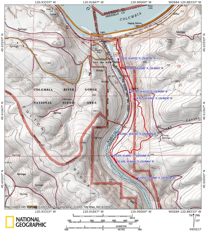
Trail Maps:
Topo Map, Wind and rain forecast for The Deschutes River, Download Garmin .gpx file
Review: 4/2/2017
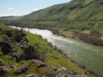
After walking about 0.2 miles across the grassy lawn you come to the south end of the grass. This is a trail Junction for several different trails. Continue along the river taking the river trail. The river trail is for hikers only and dogs have to be on a leash. Start out going through an area that’s been cleared blackberries and passes underneath some cottonwood trees. Walking along the Deschutes River you will pass a stream gauging station at a mile and at about 1.2 miles you pass a tram across the river and the junction for the Middle Trail. Continue along the river staying on the Vic Ateyeh Trail. The trail along the river is a dirt and mud packed trail with nice views to the other side of the river and down the valley of the Deschutes. After walking about 1.2 miles along the river you pass an outhouse up the hill on your left and a series of footbridges. The blackberry brambles are trying to take over some of the footbridges. This is one of those trails where it is a good idea to bring along a pair of hand pruners to clip a few brambles out of your way.
At 1.9 miles there is a junction with the trail along the river marked with a couple of branches across the trail. As of this review the signpost has burned down. Take the trail that climbs steeply up the hillside and join the Middle Trail. This provides nice overlooks and surrounding hills. In the far distance to the north you can see power towers and windmills on the Washington side of the Gorge. If you miss this junction it is at least 2 more miles along the river until you can join the bike trail.
At the top of the switchbacks is a little Plateau above the river with some nice viewpoints including a nice overlook of Rattlesnake Rapids. Follow the obvious path and drop down to the old railroad grade/gravel bike path and head upstream about another mile to a nice spot where there’s a little gulch where you can stop and have lunch out of the wind. Return back towards the boundary for the Lower Deschutes River. About 300 feet below the boundary sign is a break in the fenceline and an abandoned road. Take this gentle grade and head over a small rise to join the trail to Ferry Springs.
After climbing for a while, you walk along the side of the Deschutes River Valley and turn into a side valley. The trail here is below the surrounding plateau so there is a little less wind though on windy days the wind can still blow strongly here. In early spring you’ll be surprised by some of the different kinds of flowers growing on the slopes. There are wetland flowers scattered about such as shooting star and yellow frittilaria blooming.
Travelling along you’ll soon hear the sound of water rushing down the hillside. Drop down a bit to the stream crossing and pass through brush that grows near the water, stepping across boards that someone has laid across the muddy areas. From there the trail soon starts dropping back down to the railroad grade. On windy days you can hear the powerlines singing as the wind blows across the hills.
Different parts to the trail seem to have different microclimates. Enjoy all the different kinds of flora as you make your way down to the old railroad/bike trail along a long-ago abandoned stage coach and wagon road. The road was constructed in the 1840’s and abandoned in the 1860’s. At just under 6 miles you come to a trail branching off to the left going downhill. This is just before you cross under the powerlines. Turn left and walk a short distance down to the Vick Ateyeh Trail and the grassy lawn.
This is a great hike for kids as there are no cliffs and plenty of lizards to be seen though be sure to keep an eye out for rattlesnakes and ticks,.
This is a very popular river rafting and there’s an excellent chance that you will see rafters coming down the river.
Enjoy the photos!!
Gallery Pics
Switchback Steve