Wahtum Lake, Tomlike Mountain, OR
Vicinity Location: 70 miles east of Portland, Oregon in the Mt. Hood National Forest.
Directions:
Take I-84 and exit at the Hood River, City Center. Turn towards town and after a few blocks, turn right on Oak Street. Remember to stop for pedestrians using the crosswalks.
Turn left onto 13th St, which curves into 12th St. after several blocks. Follow signs towards Odell and Dee. 12th St. changes to Tucker Road then follow signs to Dee using the Dee Highway.
At Dee, cross the railroad tracks and pass an abandoned sawmill. After crossing the river, turn left onto Lost Lake Road. After 4.8 miles, take the right fork marked “Wahtum Lake”.
After following this road for 4.4 miles, take the right fork again and be sure to slow down for the big dip in the road. At 14.5 miles from Dee, park in the trailhead parking lot to the right. The road is paved all the way to the trailhead, but narrow with turnouts and bumps past the second fork.
There is a bathroom at the trailhead.
A Northwest Forest Park permit is required to park at the trailhead.
Length and Elevation:
9.1 miles roundtrip. Trailhead elevation: 3,925 feet. 1,940 feet gain, 1,940 feet loss. Tomlike Summit 4,555. Chinidere summit 4,673.
Trail:
Anthill Trail 409, 406B, 406, 445, Pacific Crest Trail 2000 and Wahtum Lake Trail 406H with connections to Chinidere Cutoff 406M.
There is at least one geocache along this trail at: N 45° 35.154 W 121° 48.693. Info at Geocaching.com
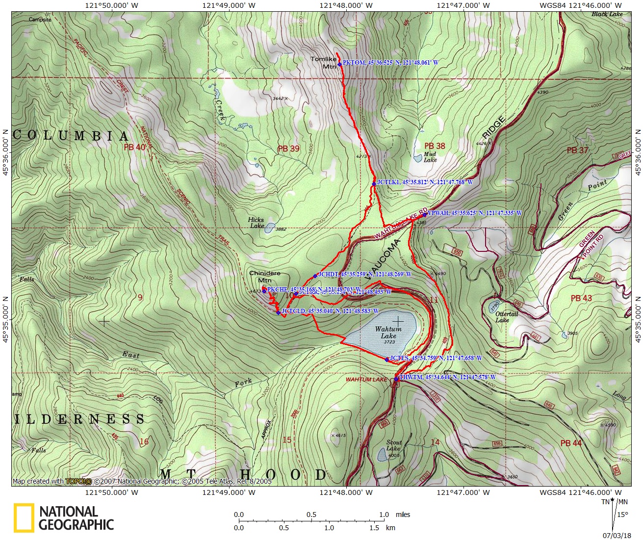
Trail Maps:
Topo Map, Download Garmin .gpx file
Review: July 24, 2008, June 30, 2018
This is a “must” hike! The trail is safe for young, experienced hikers that can handle the elevation gain. There is some rockfield scrambling on the way to Tomlike Mountain. Late snowmelts will obscure parts of this route so GPS waypoints or good compass skills are a must.
From the parking lot, go past the outhouse and go uphill. There is a sign for the Anthill trail, but it is off to the left of the trail. The trail climbs up to a ridge and follows the top of the ridge for a bit. You get occasional glimpses off to the drier parts of eastern Oregon. The trail doesn’t get a lot of maintenance and there are some occasional deadfalls to negotiate.
At one point, you get a great view of Wahtum Lake to the west through a clearing along the trail. If you step off the trail onto a scree field you have a fantastic view of Wahtum Lake. The plant understory here are mainly short herbaceous plants like ducksfoot and doronicum. After about 1.3 miles the trail crosses an old Forest Service Road. If you turn right and head east about .25 mile, you get a great view of Mt. Hood.
After crossing the road, the trail descends into the Mark Hatfield wilderness. To find the trail junction for Tomlike Mountain, look for where the Anthill Trail meets Herman Creek Trail. From the Anthill Trail junction, turn right onto Herman Creek Trail, walk about 75 feet, and turn left where the Herman Creek Trail makes the first sharp turn to the right.
In a short distance the path splits. Bear to the right and follow it along the escarpment, heading generally north for about .3 miles to the clearing. Approaching the end of the clearing heading toward Tomlike Mountian, the trail is about 150 feet west of the edge of the ridge and there should be a small stone cairn marking where the trail goes into the woods.
Keep to the right of the first gray rockpile you see in the middle of the ridge. There is a small flat area at the top and make your way up the middle of the ridge, continuing to look for the rock cairns to guide you to the path through the forest. After the rockpile you need to find the trail through the trees because you won’t be able to get through these trees unscathed because of their dense growth and sharp branches.
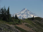
The trail breaks out of the trees for the last time and you have a pretty good view of Mt. Hood to the south, and after a short distance you go over the ridge and you have a great view of Mt. Adams on a sunny day. After you get past the krumholtz, the trail shifts over to the right side of the ridge and the grade stays fairly constant.
The climb to the top is an easy walkup and the views are spectacular. After taking in the vistas, return the way you came back to the Herman Creek Trail 406. Turn right and follow trail 406 for 1 mile to the junction with the Pacific Crest Trail. Follow the Pacific Crest Trail 2000 to the junction for the Chinidere Mountain Trail 446 and turn right. Climb up to the rocky summit for more spectacular views of the mountain peaks and the Gorge. On a clear day you can see five mountain peaks from the summit.
On the return back to the Pacific Crest Trail and turn left. After about .1 mile, you can turn right onto Chinidere Cutoff Trail 406M, which is a shortcut down to Wahtum Lake or follow the Pacific Crest Trail to Wahtum Lake.
Staying on the Pacific Crest Trail you soon backtrack to the junction for the Herman Creek Trail. Continue along the PCT through a nice forest and an increasingly damper biome. There are glimpses of Wahtum Lake to the right as you gently descend through an old-growth forest. The ground gets wetter with devil’s club appearing and soon the trail changes to a turnpike as seeps have to be channeled and drained away. Patches of yellow Monkey Flowers spring to life where they find favorable conditions.
Drop down to easy lakeshore access at a couple of day use areas. Skip the rocky user trail that goes uphill and walk about 100 feet further to Wahtum Lake Trail 406H, which forks back east and uphill for about .25 mile and then switchbacks up to the parking lot.
Enjoy the photos!!
Gallery Pics
Switchback Steve