Wauna Viewpoint, OR
Vicinity Location:
40 miles east of Portland, Oregon in the Columbia River National Scenic Area.
Directions:
From Portland, Oregon, take I-84 east for about 40 miles and take exit #41 for the Eagle Creek Recreation Area. The exit is just after the highway tunnel. Follow the road to the right and park in the first or second parking lot. Parking is limited because the parking is shared with the Eagle Creek Trail.
From Hood River, Oregon, take I-84 west to exit #41 and return to the freeway eastbound. The exit is just after the tunnel. There is no westbound exit at Eagle Creek.
Vandalism is a big problem at this trailhead. Don’t leave anything valuable in your car. Overnight parking is safest at the main parking lot, near the campground host.
Length and Elevation:
Total length is 3.6 miles out and back. Elevation gain half way is 850 feet and 0 foot loss. Elevation at the trailhead is 125 feet, the high point is 975 feet.
Trail:
Trail #400 – Gorge Trail and trail #402 – Wauna Viewpoint Trail
There are bathrooms in a stone building near the trailhead. Water is available at the Eagle Creek trailhead. The bathrooms and water are not available during the winter season. The closest restrooms in the winter are located at the Eagle Creek Trailhead, Trail #440.
A Northwest Forest Park permit is required to park at the trailhead.
Trail Maps:
Topo Map
Review: April 8, 2008
The trailhead is the pedestrian bridge across Eagle Creek. The first mile of this hike is on trail #400. After crossing the bridge there is a short nature trail loop. From the trail split, either path will loop and join back into one trail at a concrete trail marker. Take one loop on the way up and the other on the way down. The concrete sign points to Tanner Road and Wauna Viewpoint. From the sign, the trail climbs several switchbacks to an elevation of 200 feet or so, turns to the left to parallel the Columbia River, and climbs more gradually. There is a viewpoint along the way, but trees and brush have grown to mostly screen the view of the river.
At 7/10 of a mile is the next trail junction. Look for a concrete sign embedded in the embankment, just before the junction. It is the sign for the Wauna Viewpoint trail, #402. At this junction, turn left and go uphill.
The first good view of the Gorge is after you have gone up several switchbacks and pass underneath the powerlines. The power company keeps the trees cleared out and you have very nice views of Beacon Rock to the west and Bonneville Dam straight ahead on the Columbia River.
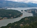
The trail continues to climb and then turns for the final uphill to Wauna Viewpoint. The end of the trail is a concrete marker that was used as a survey marker for construction of the Bonneville Dam. The viewpoint area could be used for a picnic spot, but there isn’t room for a lot of people. From here you have nice views of the Columbia River Gorge, Bonneville Dam, and the locks. Return to the trailhead the way you came.
Enjoy the photos!!
Switchback Steve