Whipple Creek Trail, WA
Vicinity Location:
About 15 miles north of Portland, OR in Clark County.
Directions:
From Portland, take I-5 North to Exit 9. Turn left on NE 179th St. and drive about 1.5 miles.
Turn left on NW 21st Ave, drive about .4 mile to the gravel parking lot.
No permits are required to park at the trailhead.
There is a portable toilet at the trailhead.
Trails:
North-South Connector Trail, 45th Parallel Trail, Stone Mill Loop Trail, South Ridge Loop Trail, North Ridge Way, Cedar Loop, Raspberry Lane with connections to various trails.
Length and Elevation:
Total distance is 2.5 miles roundtrip. Trailhead elevation is 175 feet. Highest point is 200 feet. Lowest point is 90 feet.
Total elevation change is 350 feet up and 350 feet down.
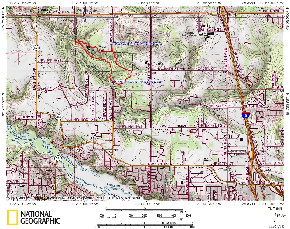
Trail Maps:
Clark County Map, Topo Map, Download Garmin .gpx file
Review: 11/4/2016
From the parking lot walk along the trail and go straight into the woods on the North-South Connector trail. Turn left at the first junction, drop down a couple of steep little switchbacks, and cross two bridges then climb back up and take a left turn at the next junction. This trail will go about 1, 000 feet to a junction with the Grist Mill, or Stone Mill Trail. Turn left and you’ll soon come to the eastern boundary of the park. Turn right when you get to the fence and walk along the edge of a pasture and then head back in the woods. The main trail goes down a dip and turns a little muddy going down the slope in the rainy season.
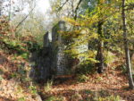
Once the trail levels out again, it is muddy but soon turns back into gravel and winds through the forest. Soon you start descending several sweeping switchbacks to the ruins of the old grist mill. All the wood has rotted away and only the stone structures of the mill remain. There is a bench right by the mill where you can take a snack break. From there, walk across two little streams and continue straight, following the lower of the two trails. This gently starts winding up the slope away from the creek.
At the top of the hill is another junction with the South Ridge Trail. Stay to the right at this junction with South Ridge Trail. In about 50 feet, there is another trail junction where you turn left to stay on the South Ridge Loop. In about 200 feet is another junction with the North-South Connector Trail and South Ridge Loop where you turn left and follow the South Ridge Loop which generally heads northwest. Continue on the South Ridge Loop as the trail drops gently downhill above the stream. After about .5 mile, turn right to follow the trail down Carousel Hill and across Whipple Creek. Once you cross the creek on the little bridge, make a right and follow North Ridge Way. Climb up the hill away from the stream, walking through a small cedar grove, and in about .2 mile turn left at the junction for the Cedar Loop Trail.
Travel under a fairly dense canopy created from a mix of cedars, firs, and maples. After just another tenth of a mile or so you come to another junction where you turn left and take Raspberry Lane out of the woods and along the edge of a large meadow. From here it is easy to see the parking lot. Make a left at the end of Raspberry Land and return to the parking lot.
There has been a lot of trail work done in the past few years. All the major trails are gravelled which makes them great for children because you can choose the distance, there are no cliffs, and the grist mill ruins and streams provide interest. This is a great hike for fall or spring because the mud is now under control. These trails are popular with horses so be sure to keep your dog on a leash and under control at all times.
Enjoy the Photos
Gallery Pics
Switchback Steve