White River – Boy Scout Ridge, OR
Vicinity Location:The trailhead is about 50 miles southeast of Portland, Oregon in the Mt. Hood National Forest.
Directions: From Portland take I-84 East to the Wood Village, exit (16A). Head south and turn left onto NE Burnside Rd. Heading East, Burnside will merge into Highway 26. Follow Hwy 26 past Government Camp and exit on Highway 35 to Hood River. Follow Hwy 35 for 4.1 miles. Turn left into the White River West Sno-Park. If you cross over White River then you have driven too far.
In winter, it is required to carry chains or have traction devices.
The parking lot is a very popular location and can fill up on nice weekends.
There are pit toilets at the trailhead.
A current Sno-Park permit is required to be displayed between November 1 and April 30. Oregon permits cost $4 a day, $9 for three days or $25 for the season. The permits can be bought on-line, in Government Camp other outdoor stores or DMV offices.
Only attempt this route during moderate or low avalanche conditions. The steep slope at the head of the White River valley can be very dangerous. During high avalanche danger use Boy Scout Ridge for an out-and-back trip and avoid the head of the White River Valley. Understand how to evaluate avalanche conditions and when to stay off avalanche prone slopes. You can see avalanche forecasts here: Northwest Avalanche Center
National Weather Service Snow Level forecast: Northern Oregon Cascades
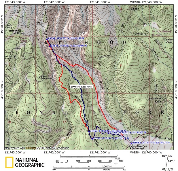
Trail Maps:
Topo Map, Download Garmin .gpx file, Open Garmin .gpx file
Length and Elevation:
6 miles roundtrip. Elevation at the trailhead is 4,250 feet. Total gain is 1,800 feet and loss is 1,800 feet. Highest elevation is 5,780 feet and the lowest elevation is 4,235 feet.
Review: March 3, 2018, January 9, 2022, January 15, 2023
The loop trip is not to be taken when avalanche danger is high and you are responsible for assessing the steep, open slope on this hike for avalanche danger and your own personal safety. Use the map to climb up along the PCT on Boy Scout Ridge and return the same way.
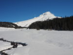
From the northwest corner of the parking lot, follow the well-used path along White River. On a clear day the views of Mt. Hood with White River flowing in the foreground are spectacular. In winter the glacial melt is minimal and the river changes from milky white to a clear flowing stream.
Enjoy the wonderful views going up the wide valley and you can find moments of solitude once you pass the sledding hills. White River never freezes over so take an opportunity to go to the water’s edge for the refreshing sounds and look for icicles that form at the water’s edge.
Continue to wander up the valley, passing under powerlines and then climb up to the left as you near the head of the valley. Make you way over to a steep slope and consider if this is a good place to turn around.
If you believe it is safe to climb the steep slope then make your way up the steep ascent, keeping to small ridges to reduce the effects of possible avalanches. After gaining about 150 feet up the steep slope you continue up a gentler slope then onto a gently sloping plateau with panoramic views in all directions. Wander around looking a the different snow formations and silver trees stripped of bark from winter storms. Be careful to stay away from the cliff edges because cornices are common.
Continue up the gentle incline to a patch of forest and easily find a way through to views of Timberline Lodge, Silcox Hut, and Mt. Hood. The northern edge of the forest is a great place to turn around.
Head back down along this flat ridge across the open space and bear slightly right to follow the Pacific Crest Trail into the forest. Use the GPS track to follow the trail through the lovely fir and hemlock forest, watching out for snow bombs falling from trees after a heavy snow.
The PCT is on the west side of Boy Scout Ridge and goes steadily downhill without switchbacks for the first 1.8 miles. On the PCT route there is a small stream about 1.5 miles after you enter the forest. If you miss the bridge on the PCT, it can be a bit of a scramble to cross when the snow is deep. If you follow the Boy Scout Ridge GPS track you stay above this stream.
From the stream continue about .75 mile through the forest to the junction for the Yellowjacket Trail. Make a sharp left here and head down fairly steeply making sure to not lose the trail because of the sharp turns the trail takes. This section of trail usually has been used by other snowshoers and should be easy to find.
The trail drops down to cross Mineral Creek on a bridge. The final .5 mile of the trail is a gentle downhill back towards White River, the crowds of children, and the parking lot.
Enjoy the photos!!
Gallery Pics
Switchback Steve