White River Trail, OR
Vicinity Location: The trailhead is about 50 miles southeast of Portland, Oregon in the Mt. Hood National Forest.
Directions: From Portland take I-84 East to the Wood Village, exit (16A). Head south and turn left onto NE Burnside Rd. Heading East, Burnside will merge into Highway 26. Follow Hwy 26 past Government Camp and exit on Highway 35 to Hood River. Follow Hwy 35 for 4.1 miles. Turn left into the White River West Sno-Park. If you cross over White River then you have driven too far.
In winter, it is required to carry chains or have traction devices.
The parking lot is a very popular location and can fill up on nice weekends during the snowy season.
A current Sno-Park permit is required to be displayed between November 1 and April 30. Oregon permits cost $4 a day, $9 for three days or $25 for the season. The permits can be bought on-line, in Government Camp other outdoor stores or DMV offices.
National Weather Service Snow Level forecast: Northern Oregon Cascades
There are pit toilets at the parking lot.
Length and Elevation:
5.6 miles roundtrip. Elevation loss of 800 feet and gain of 800 feet. Elevation at the northern trailhead is 4,282 feet. Highest point is 4,282 feet. Lowest point is 3,630 feet.
Trail:
White River Trail #538 with connections to multiple trails
There are no geocaches along this trail.
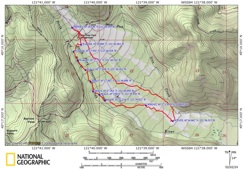
Trail Maps:
Topo Map, Download Garmin .gpx file, Open Garmin .gpx file
Review: December 21, 2021
Walk downstream from the White River West sno-park and go under Highway 35. Follow the right bank of White River downstream for about 700 feet then follow a gully away from the main streambed.
Use the GPS route to find your way through the open forest to the corridor cut through the forest for the trail. There are blue diamonds of various ages sporadically along the route.
Take Trail 538 downstream from Highway 35 for about 2 miles to where it crosses one of the braided streams of Mineral Creek. Continue along Trail 538 using your routefinding skills. and GPS There are few blue diamond markers after 2 miles so you will have to look for logical clearings in the trees and some tree trunks have flush-cut branches on the trunks that are almost grown over.
Nearing the 3 mile mark you will see several 4×4 wood posts marking the trail, one pretty much in sight of the other. At the wood post near the 3 mile mark turn left and head to the White River. Walk upstream along the White River for a bit and then follow a small tributary stream.
Find openings in the forest heading north by northwest. There comes a point where the forest closes in and you’ll need to head generally north through breaks in the forest and cross over a couple of little streams. Route find through open areas in the trees until you come out onto the debris flow of White River.
From here it is easy to find open spaces to snowshoe upstream back to your trail along the White River with outstanding views of Mt. Hood on clear days.
This loop offers routefinding challenges along with solitude and scenery and this route has no avalanche danger because the whole route is in the White River floodplain and does not get close to any steep slopes.
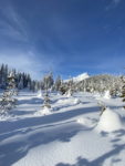
Enjoy the photos!!
Gallery Pics
Switchback Steve