Whittier Ridge Trail, WA
Vicinity Location: About 10 miles north of Mt. St. Helens, WA in the Gifford Pinchot National Forest.
Directions: Drive to the Norway Pass trailhead. From Portland, drive north on I-5 to exit 21 at Woodland. Turn right and drive east for 27.5 miles on SR503 to the small community of Cougar. Continue east through Cougar and SR503 turns into FR90 for 18.6 miles and bear slightly left to take FR25 for 24.3 miles to FR99.
From FR99, drive 8.8 miles to the junction with FR26. Turn right onto FR26 and drive 1 more mile to the Norway Pass Trailhead. From Portland, plan on drive for 2 ½ to almost 3 hours depending on road conditions and traffic.
A Northwest Forest Pass is required to park at the trailhead.
No dogs are allowed on the trail and mountain bikes are only allowed on parts of this trail. There is a restroom at the trailhead.
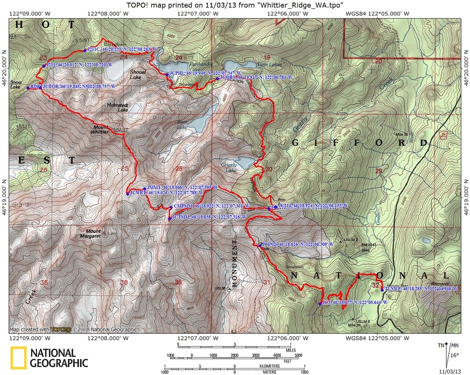
Trails: Boundary Trail #1, Whittier Ridge Trail, Lakes Trail #211 with connections to Independence Ridge Trail #227A, Independence Ridge Trail #227. Shovel Lake Trail #211C, Panhandle Lake Trail #211B.
There are no geocaches along this trail.
Trail Maps: Topo Map, Download Garmin.gpx file
Trail Races: Early August – Volcanic 50 Mid-August – Bigfoot 200
Length and Elevation: This is a loop hike and the distance is 14.9 miles. Trailhead elevation is 3645 ft. There is 4,700 feet elevation gain and 4,700 feet of elevation loss.
Review: October 13, 2013. This is a loop trail but weather conditions may dictate an out-and-back trip.
From the north end of the parking lot, head north, straight away from the parking lot. You are walking on Boundary Trail #1 which can be a bit confusing because right near the parking lot you pass a junction with Boundary Trail #1 on the right. The trail you need to take curves slightly to the left and in about 200 feet, drops down a bit and crosses a footbridge over a small creek. From here the climb begins.
In about 1.1 miles there is a junction with Boundary Trail #1 and the first junction with Independence Ridge Trail #227A. Keep to the right at this junction and the next one, a junction with Independence Ridge Trail #227. The Independence Ridge Trail tends to have washouts and seems to be closed often. Just after the junction, drop down to Norway Pass, a small saddle with wonderful views of Spirit Lake. If conditions are right, then logs floating on the lake will be pushed into the northern arm of the lake. These logs were blown down by the cataclysmic explosion from 1980, then a huge lahar swept into the lake raising the lake level several hundred feet and sloshing the lake up the slopes and scouring off the fallen trees. After contemplating the devastation from the blast and wondering how logs can still be floating after more than 30 years, ascend up the well-maintained trail.
In about .7 mile is a junction for the Lakes Trail #211. Continue heading straight to stay on Boundary Trail #1. The Lakes Trail will be used on the return leg of the trip if all goes well. After a while, you’ll pass a nice rock overlooking the valley, then come to one of the Mt. Margaret backcountry camps. The camp has an outdoor composting toilet. There is a seasonal stream at the campsite which can be dry just before the fall rains start. Some years there is a snow patch near the camp that can be used for water. Remember not to use pink or red snow. Being in the blast zone gives constant views of Mt. St. Helens and walking the trail provides one continuous panoramic view of the nearby and distant mountains.
Make a left at the camp and follow the trail as it continues uphill to a small saddle with nice views of Boot Lake and Obscurity Lakes which were carved out by glaciers long ago. Follow the trail along the south side of the slope for .2 mile to another saddle wherein lies the junction for Mt. Margaret and Mt. Whittier Trails.
Taking the Whittier Ridge junction to the right, you will immediately notice a difference in the trail. It is brushy from being lightly travelled and there are some deadfalls to negotiate.
Do not take the trail over Whittier Ridge is there is still spring snow. Parts of the trail are shaded most of the day and are very dangerous when covered in icy snow. Part of the trail is on a near knife edge only about 2 foot wide, other portions are blasted from the side of the cliff, and there are a few short scrambles. If you are at all uncomfortable with heights, do not take this trail. If the weather is very windy or the trail is socked in, do not take this trail.
The trail comes out after a bit then then comes to a little peak ahead of you. The trail goes to the right side of the rock, 5 ¼ miles from the trailhead comes to a spine that connects to the south shoulder of Mt. Whittier. If you look across the valley you may be able to see the trail switchbacking up the side of the ridge. From here you have a great view to the right of Boot Lake and Mt. Rainier on the right, and Mt. St Helens on the left. Behind you can see Mt. Adams on a clear day.
From the summit of Mt. Whittier is a 360 degree panoramic view of mountains too numerous to mention them all. All the major volcanic peaks are in view along with several lakes. Holmstedt Lake lies just to the northeast of the peak. In the west, you can see a sliver of Coldwater Lake, which was created when a mudflow dammed Coldwater Creek.
At mile 5.4, the trail skirts a section where the trail was blasted out of the cliff face. If the weather is bad or in early spring, this is a dangerous portion because it is shaded all afternoon and is slow to melt out in the spring. Next the trail heads pretty steeply uphill to gain the ridgeline. There are places that aren’t marked and the only way to find the trail is to scout where other people have walked.
On the ridge the trail is very sketchy in places and you have to pick your way along the splintered ridge. Sometimes dropping off the ridge a bit to circumvent an especially rugged spot.
Near the end of the ridge is a place where the trail was rerouted several years ago. The reroute gains just a bit of elevation, then drops sharply off the right side of the ridge. Follow this poor trail down a few switchbacks. The track quickly improves, then descends across a steeply sloped meadow down into tree cover and connect with Lakes Trail at Pleasant Pass.
If you try to take the old trail, this abandoned trail descends the left side of the ridge, then turns sharply right and goes beneath rock cliffs. Part of the old trail has broken away from the cliffs and would be quite time consuming to navigate.
At the Lakes Trail it is about 6.3 miles back to Norway Pass. Turn right and head east on the mostly level trail. The trail soon passes the junction to Shovel Lake on the right and continues to some cliffs with a great view down into Shovel Lake.
Panhandle Lake is fed by a lovely stream that cascades down the hillside above the lake providing a good flow of water. The stream takes a few steps to hop across. The trail drops down and goes along Panhandle Lake, then starts climbing out of the bowel the lake sits in.
You’ll start crossing a series of seasonal and all year streams from Panhandle Lake and past Obscurity to Grizzly Lake. All the streams are easily navigated by stepping on rocks piled in the streams.
This year there has been maintenance on the Lakes Trail. The Alders have been brushed away and some of the washout areas have been repaired.
The trail climbs fairly steeply up to Grizzly Lake, which is a small log-choked lake without much appeal. The trail continues climbing at a moderate rate for about another 900 feet up to Grizzly Pass. It is a long 900 foot slog up to Bear Pass and by now you’re getting pretty tired as you climb up to Bear Pass.
Coming back from Norway Pass, you may have forgotten that you had some downhill sections coming from the trailhead. How easy it is to forget that the first two miles of the trail had elevation gains and losses, but the climbs on the return leg have to be negotiated so you can finish this awesome hike.
Do not take the trail over Whittier Ridge is there is still spring snow. Parts of the trail are shaded most of the day and are very dangerous when covered in icy snow. Part of the trail is on a near knife edge only about 2 foot wide, other portions are blasted from the side of the cliff, and there are a few short scrambles. If you are at all uncomfortable with heights, do not take this trail. If the weather is very windy or the trail is socked in, do not take this trail.
Average speed was 1.6 mph. We hiked for 9 ½ hours.
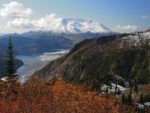
Enjoy the photos!
Gallery Pics
Switchback Steve