Wind Mountain, WA
Vicinity Location:
About 46 miles northeast of Portland, OR on the north shore of the Columbia River.
Directions:
From Portland, Oregon, there are two ways to drive to the trailhead. If you have an extra 30 minutes then make your trip a loop drive. For the loop drive, take I-205 north across the Columbia River. Exit I-205 on HWY 14 east for about 28 miles through the town of Stevenson. For the non-loop option, take I-84 east from Portland and take exit #44 for Cascade Locks. Take the first right turn, just after you go under the Bridge of the Gods. The toll for cars is $3.00 going either way across the bridge. Cross the bridge, and turn right onto HWY 14 and drive 2.5 miles to Stevenson.Once you get to Stevenson, drive about 5 more miles east to Wind River. Just about 1 mile past Wind River, turn left onto Wind Mountain Road. Continue following the road up the hill and in one mile, continue to the road and continue to the right at the intersection of Home Valley Road. After .4 mile, turn right on Girl Scout Camp Road and continue to the parking area. There is also a sign for Wind Mountain Trailhead on the stop sign across the road.
Drive up Girl Scout Road for .3 mile and park at the top of the rise where the road widens into an area that looks like a gravel pit.
To return, take HWY 14 west back through Stevenson, and after about 2.5 miles, turn left and cross the Columbia River at the Bridge of the Gods. The toll for cars is $3.00 going either way across the bridge.
After the bridge, the road loops around and intersects Hwy 30, Cascade Locks Hwy, near the base of the bridge. Turn left here and you will merge onto I-84 west in about ½ mile. Follow I-84 west, back to Portland.
No permits are required at this trailhead.
No bathrooms are available at the trailhead.
Length and Elevation:
2.7 miles roundtrip. Elevation gain 1,051 Feet and loss 188 feet to the summit. Total gain and loss is 1,239 Feet. Elevation at the trailhead is 998 feet, the summit elevation is 1,861 feet. Lowest point is 827 feet.
2.7 miles roundtrip. Elevation gain 1,051 Feet and loss 188 feet to the summit. Total gain and loss is 1,239 Feet. Elevation at the trailhead is 998 feet, the summit elevation is 1,861 feet. Lowest point is 827 feet.
Trail:
Wind Mountain Trail.
There is at least one geocache along this trail at: N 45° 42.191 W 121° 45.318. Info at Geocaching.com
Trail Maps:
Topo Map, Download Garmin .gpx file
Review: February 21, 2010
Walk downhill down the dirt road about .1 mile to where a rocky trail goes off to the right, uphill. There is a tiny pulloff on the left side of the road.
The rocky little trail goes uphill past moss and fern covered ground. The understory growth is mainly Oregon Grape, ferns, and salal with Douglas Firs providing shade.
As the trail climbs, it becomes less rocky and winds around towards the Columbia River, climbing up the eastern slope of Wind Mountain. The trail becomes more forested and less rocky. Areas of this trail are sloped a bit and on a wet, rainy day the trail could become slick.
The trail generally winds around Wind Mountain, climbing up through fairly dense stands of Douglas Firs. Wind Mountain lives up to its name as the winds rush through the treetops.
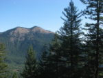
After climbing for about .75 mile, you come to the first basalt scree fields which allows views to the east of Augsberger Mountain and Dog Mountain, which are on the next ridge to the east of Wind Mountain. The trail soon re-enters the woods and continues to climb fairly steeply up to the summit of Wind Mountain.
On up the trail there is a signboard with a poster warning you not to disturb any artifacts you may find. Just up the trail a bit is another sign talking about the Wind Mountain Spirit Qwest Site and warning that the archeological site is extremely fragile and walking over it will damage cultural features. All hikers are to stay on the trail or within the three designated viewing area on the summit.
Near the top, at the last small slope before the summit, the trail splits. The trail to the left is quite narrow and leads to a scree field with views of Mt. Adams, Dog Mountain, and the eastern part of the Columbia Gorge. The main trail goes straight ahead and comes out on a scree slope that overlooks the Columbia Gorge to the west and leads to the summit of Wind Mountain.
There is no point where there is 180 degree panoramic view because of the trees growing at the summit, but the scree slopes provide expansive views of the Gorge. To the south is Mt. Defiance, which can be identified by the repeater towers up on top of the mountain.
Retrace your steps back down to Girl Scout Road, then walk uphill back to the parking area.
This is a good low-elevation hike for the winter months. There are areas of the trail that traverse steep slopes which could be dangerous for young, inexperienced hikers.
Enjoy the photos!!
Gallery Pics
Switchback Steve