Wygant Peak, OR
Vicinity Location:
65 miles east of Portland, Oregon in the Columbia River National Scenic Area.
Directions:
From Portland, Oregon, take I-84 east and take exit 58, Mitchell Point Overlook and drive uphill to the parking lot. There is no westbound on-ramp at exit 58. To return to Portland, merge onto I-84 east and drive towards Hood River. Take Exit 62, turn left at the stop sign. Cross over I-84 and take the next left and merge onto I-84 west back to Portland.
From Hood River, Oregon, take I-84 west to exit 56, Viento State park, and return to the freeway eastbound. For the return trip, merge onto I-84 east.
There is an outhouse at the parking lot.
No permits are required to park at the trailhead.
Length and Elevation:
Total length is 7.6 miles with a loop and an out-and-back trail to Wygant Peak. Elevation gain to Wygant Peak is 2,070 feet and 100 foot loss. Elevation at the trailhead is 140 feet, the high point is 2,214 feet.
Trail:
Wygant Peak Trail. Connects to Mitchell Point Overlook Trail.
There is at least one geocache along this trail at: N 45° 41.905 W 121° 37.885 Info at Geocaching.com
Trail Maps:
Topo Map, Download Garmin .gpx file, Open Garmin .gpx file
History:
The Chetwoot Loop was constructed by volunteers headed by Basil Clark. The trail was named for the Chinook word for bear. Basil encountered a bear while working on the trail and decided to name the trail Chetwoot. There were several hand-painted signs on this trail in the past, but I only found one of the trail signs as of this review. The Chetwood trail has a slide at Perham Creek that turns people around.
Review: April 13, 2008, April 21, 2019
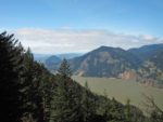
From the parking lot, walk west to the paved trail. There should be a signpost next to the trail for Wygant trail. The road, the original Columbia River Highway, heads slightly downhill to the west. The road takes a left, goes uphill, and changes into a dirt road. The trail soon branches off to the right at the first turn of the road. The trail follows the stream a bit, then fords the stream on a rounded rocks set into the streambed. Continue through the woods to the west. The trail goes through nice second growth trees with Ladyslipper Orchid and Trilliums blooming in the springtime. The trail uses parts of the old Columbia River Scenic Highway for about ¼ mile then the trail leaves the road and goes up a small creek valley with a small waterfall. The stream splashing over the rocks makes the narrow valley feel cool. After hopping across the small stream, the trail ascends a couple of switchbacks and rounds a corner to head west. There are some views of the Columbia River through the trees. Now the trail levels off for a while until it reaches the junction for Perham Creek and the viewpoint. The trees at the viewpoint obstruct portions of the view, but there is still a nice view of the Columbia River through the trees.
Pass back under the Oregon White Oaks and return to the junction and head along the creek. The trail drops down to Perham Creek where you cross on an old log that has fallen across the creek. From there, the trail ascends up the hillside through the woods. The trail winds through the woods and comes to a junction. The branch to the right goes about 0.25 mile leads out to very nice, unobstructed views of the Gorge.
Back on the trail, the trees have been cleared for a service road for the powerlines. Turn left on the road and climb pretty much straight uphill under the powerlines for a short distance and then back into the woods on the trail. The trail switchbacks up the hillside to another junction. You can see there were viewpoints along this trail because there are old post and cable railings on a couple of the switchback corners. The trees have grown to block the views of the Gorge. To the right is a very nice viewpoint of the Gorge. This viewpoint is not for small children.
Back at the junction, continue on a few more switchbacks up to the junction for Wygant Peak Trail and the Chetwoot Loop Trail. From here, turn uphill to the right to climb the Wygant Peak Trail. The trail to the peak climbs several more switchbacks and fairly steep sections.
The peak is an anti-climax. There is a little rock cairn in a wooded forest. There really aren’t any views from the peak but if you go down the other side of the peak on a user trail for about 0.1 mile, you will come out to a large meadow that overlooks the Columbia River and Wind Mountain.
There is poison oak on this trail and you’ll probably walk through on some sections of the trail and if you go around any deadfalls in the trail. This is a nice walk through the woods and a couple of nice viewpoints. Perham Creek pleasantly splashes along and the crossing is quite scenic.
Enjoy the photos!!
Switchback Steve