Yocum Ridge, OR
Notice: 6/25/19 – A severe thunderstorm in August 2014 swelled streams on Mt. Hood and washed out the bridge over the Sandy River. One person on the bridge was swept away and died according to local news sources. This trail is not suitable for inexperienced hikers at this time. Fallen trees or wading must now be used to cross the Sandy River. The river can swell to uncrossable levels on hot or rainy days.
Vicinity Location:
The trailhead is about 42 miles southeast of Portland, Oregon in the Mt. Hood National Forest
Directions:
From Portland take I-84 East to the Wood Village, exit (16A). Head south and turn left onto NE Burnside Rd. Heading East, Burnside will merge into Highway 26.
Follow Hwy 26 for 26.8 miles to Zigzag. When you drive past Welches, you are getting close to Lolo Pass Road. East Lolo Pass Road is just after the Hoodland Fire Station and Salmon River Road, which are both on the right and the Zigzag Mountain Store on the left. Turn left onto E. Lolo Pass Road and follow the twisty paved road for about 4.2 miles and turn right onto a paved road, just a little past the end of the road maintenance sign.
About 4.9 miles from Hwy 26, turn right and cross over the Sandy River. At about 5.3 miles is a brown road sign. Continue straight, towards the Ramona Falls Trailhead, passing the junction on the right.
At 6.6 miles is another junction and sign for the Ramona Falls Trailhead. Turn left at the junction with Forest Service Road 1825 and continue on the single lane paved road. Watch out for some fairly big potholes in the pavement.
The road leads to a large gravel parking area. The trailhead is on the right side of the parking area.
A wilderness permit is required. The free self-registration for a wilderness permit is about 200 feet from the trailhead along the trail.
Bathrooms are available in the summer.
A Northwest Forest Park permit is required to park here.
The access road to this road is closed during the winter.
Length and Elevation:
19 miles roundtrip, elevation gain 4,000 feet and loss 370. Total gain and loss is 8,740-feet. Trailhead elevation is 2,450 feet, Ramona Falls is at 3,178 feet. The high point of the trail is 5,960 feet.
Trail:
Ramona Falls Loop Trail #797, Yocum Ridge Trail #771,Timberline Trail #600 and overlapping with the Pacific Crest Trail #2000.
There is at least one geocache for this trail at: N 45° 23.215 W 121° 49.876 Info at Geocaching.com.
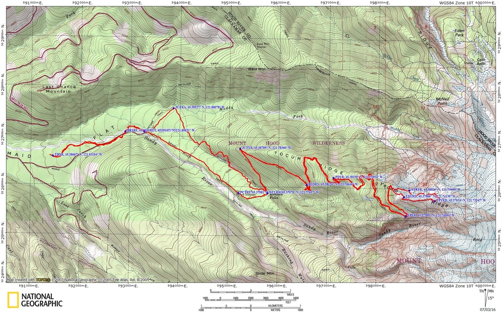
Trail Maps:
Topo Map, Download Garmin .gpx file
Review: August 8, 2014
The trail enters the woods and leads past the Wilderness area registration box. The wide trail comes out to the bank of the Sandy River. You can see evidence of erosion and undercutting. Don’t venture too close to the edge of the bank. It could collapse if you get too near the edge.
After walking along the river, the trail comes to a crossing of the Sandy River. The old bridge has been washed out and now there is a seasonal bridge which is removed in the late fall.
In 2011 there were a couple of downed trees that could be used for crossing the stream. Au-natural log crossings become dangerous after the tree has been dead a couple of years because the bark can suddenly, and without warning, slough off when you walk across the log. If the seasonal bridge is gone, the logs are gone, or crossing on the logs is too dangerous, then the creek is about a knee-deep ford. You can’t see the bottom of the stream because of the glacial silt.
Continue upstream about .25 mile to the junction of Ramona Falls Loop and the Pacific Crest Trail. Turn left at this junction and continue up the trail. The trail to the right is the return trail.
After walking about .5 mile through the pleasant forest, over Ramona Creek, and along the gently rolling landscape, you come to another junction, JCRF1, on the Ramona Falls Trail. Turn right and walk past a horse gate, a fence built to stop horses, and continue just a few hundred feet farther along, to another trail junction. A small trail leads off to the left to a hiker bridge over the Muddy Fork of the Sandy River and then to the Pacific Crest Trail. From the junction, the main trail continues southeast towards Ramona Falls gaining only about 400 feet in the next mile. The trail parallels Ramona Creek for much of the next mile, crossing over the creek a couple of times. The creek may be the prettiest in the fall when the golden leaves fall along the trail and into the stream.
The trail passes a junction to the Timberline Trail just before Ramona Falls. Just downstream of Ramona Falls is a very nice log bridge over the creek. On the other side of the bridge is an area that has been trampled of most vegetation but is a lovely spot to watch the falling water.
The 120 foot waterfall cascades down a blocky basalt cliff and the water fans out across the face of the falls. This cascading water makes a wonderful sound and with the water falling down the rocks there is a below average amount of spray from the falls which allows you to linger near the falls without getting soaked from the spray.
Crossing back over the bridge, walk a couple hundred feet to the junction to the Timberline Trail and turn right, heading uphill. In about .2 mile is the junction to the right for the Yo***** Ridge Trail. Turning right, you walk along the side of the ridge and continue to gain elevation.
At about 6.5 miles from the trailhead you come to another big boulder field where you get a glimpse of Mt. Hood and the Sandy River off to your right. At 7 miles you pass by a small mountain stream where you could get water. It looks like you could camp here but there is a no camping sign on a tree. Take a break at the edge of the small meadow then continue up the trail.
The trail continues to gently climb and you go to the north side of the ridge. Just before it bends back into the trees there are nice views of Mt. Adams, Mt.Rainier, and Mt. St. Helens. Soon the trail goes back across the ridge and switchbacks to gain elevation. After climbing for a half mile you pass by the base of the boulder slope. The trail makes a large switchback and crosses right at the top of the boulder field which provides a view to the northwest. Though there are no mountain peaks from the boulder field, there are forested ridges fading of into the distance.
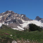
After walking for about 8 miles, the trail comes out of the trees and crosses sloping mountain meadows and the magnificence of the views increase with every bend in the trail. You soon pass a junction on the left and come to a precipice with views into the Sandy River canyon. From here you can see some nice waterfalls and glaciers hanging on Mt. Hood. As with many places on Mt. Hood, you will be visited with the biting black flies during most of the summer. The best you can do is not stop too long or too often and find resting spots in the breeze.
If you want to take in the fantastic views and make this your final destination, you can turn around here or if you desire, walk back to the junction, take the right fork and make your way along the meadow. Soon the trail starts dropping down to go underneath a rocky cliff then loops across the face of the ridge and bends around to more spectacular views of Mt. Hood. This is another good choice for a turnarouind spot. From here the trail climbs fairly steeply near the spine of the ridge.
Finally you get to a nice spot after working you way across a treacherous little ridge. There is a small mountain meadow here. You can hear streams in the distance and nearby you can see the Sandy Glacier to the right and the Elliot Glacier on the left side of the ridge.
From the top of the ridge, you can work your way down some snowfields and rocks to where melted snow comes out, then follow the stream to where it passes through a wildflower meadow and cascades down a rock face. From there, keep fairly level and follow the valley past some nice flat areas which are good for camping sites. You should find a way trail that will take you through a rock field and allow you to scramble up the hill a bit and reconnect with the trail.
Enjoy the walk down the back mountain and through the forest.
Enjoy the photos
Link to Photos
Switchback Steve