Timberline Trail - Cutoff Trail |
||||
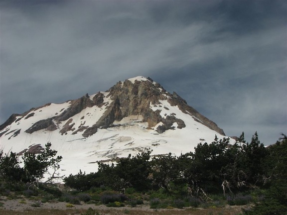 |
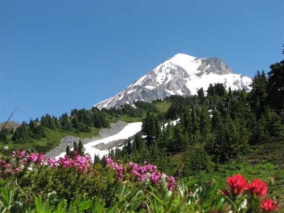
Beautiful Mt. Hood is located east of Portland Oregon |
 |
•Mt. Hood Wikipedia |
|
| Mileage Table using cutoff trail near Bald Mtn. | Mileage Printable Table Metric Printable Table | Excel Download | |||
|---|---|---|---|---|---|
| Landmark | CCW (miles) | CCW w/Paradise Park (miles) | CW (miles) | CW w/Paradise Park (miles) | Elevation (feet) |
| Wy-East Lodge | +0.1 | +0.1 | +0.1 | +0.1 | 5897 |
| Timberline Lodge | +0.1 | +0.1 | +0.1 | +0.1 | 5940 |
| Begin/Finish Timberline Trail | 40.3 | 41.3 | 0 | 0 | 6042 |
| Jct. Hidden Lake Trail #779 | 38.8 | 39.8 | 1.5 | 1.5 | 5703 |
| Cross Zig Zag River | 36.9 | 37.9 | 3.4 | 3.4 | 4774 |
| S. Jct. Paradise Park Loop Tr.#757 | 36.6 | 37.6 | 3.7 | 3.7 | 4926 |
| Jct. Paradise Park Tr.#778 | 36.1 | 37.1 | 4.2 | 4.2 | 5238 |
| N. Jct. Paradise Park Loop Tr.#757 | 34.2 | 34.1 | 6.1 | 7.2 | 5465 |
| Ramona Falls | 30.2 | 30.2 | 10.1 | 11.1 | 3444 |
| Muddy Fork Crossing | 27.1 | 27.1 | 13.2 | 14.2 | 4134 |
| Jct. Cutoff Trail and PCT | 25.4 | 25.4 | 14.9 | 15.9 | 4300 |
| Cross McGee Creek | 23.2 | 23.2 | 17.1 | 18.1 | 5440 |
| Cairn Basin Shelter | 22 | 22 | 18.3 | 19.3 | 5635 |
| Jct Vista Ridge Tr.#626 - Wy'East Basin | 20.8 | 20.8 | 19.5 | 20.5 | 5802 |
| Elk Cove Tr.#631 | 19.5 | 19.5 | 20.8 | 21.8 | 5457 |
| Cross Eliot Creek | 14.6 | 14.6 | 25.7 | 26.7 | 5460 |
| Cloud Cap Camp | 14 | 14 | 26.3 | 27.3 | 5856 |
| Cooper Spur Shelter | 12.7 | 12.7 | 27.6 | 28.6 | 6779 |
| Cross Lamberson Spur | 11.3 | 11.3 | 29 | 30 | 7330 |
| Jct. Gnarl Ridge Tr.#652 | 8.5 | 8.5 | 31.8 | 32.8 | 5632 |
| Jct. Newton Creek Tr.#646 | 7.6 | 7.6 | 32.7 | 33.7 | 5592 |
| Cross Clark Creek | 6.1 | 6.1 | 34.2 | 35.2 | 5513 |
| Jct. Umbrella Falls Tr.#667 | 3.7 | 3.7 | 36.6 | 37.6 | 5756 |
| Cross the White River | 2 | 2 | 38.3 | 39.3 | 4934 |
| Exit the PCT begin Tr.#600 | 1.4 | 1.4 | 38.9 | 39.9 | 5308 |
| Begin/Finish Timberline Trail | 0 | 0 | 40.3 | 41.3 | 6042 |
| Following the Timberline Trail and not using the Cutoff Trail | CCW (miles) | CCW w/Paradise Park (miles) | CW (miles) | CW w/Paradise Park (miles) | Elevation (feet) |
| Jct. Cutoff Trail and PCT | 0 | 0 | 0 | 0 | 4300 |
| Jct Bald Mountain Trail | 0.7 | 0.4 | 0.7 | 0.4 | 4269 |
| Jct. Cutoff Trail and PCT | 1.2 | 1.2 | 1.2 | 1.2 | 4300 |
| Side Trip to Elk Meadows | CCW (miles) | CCW w/Paradise Park (miles) | CW (miles) | CW w/Paradise Park (miles) | Elevation (feet) |
| Jct. Gnarl Ridge Tr.#652 | 0 | 0 | 0 | 0 | 5632 |
| Elk Meadows Shelter | 1.3 | 1.3 | 1.3 | 1.3 | 5037 |
| Jct. Gnarl Ridge Tr.#652 | 2.6 | 2.6 | 2.6 | 2.6 | 5632 |
One of the best ways to experience Mt. Hood might be to grab yourself some of the software I use and map out some cool trails to explore.
CalTopo is web based; Viewranger has smartphone and web based applications; Gaia has smartphone and web based applications. Garmin has proprietary PC software and dedicated devices.
Timberline Trail Topo Map with entire route.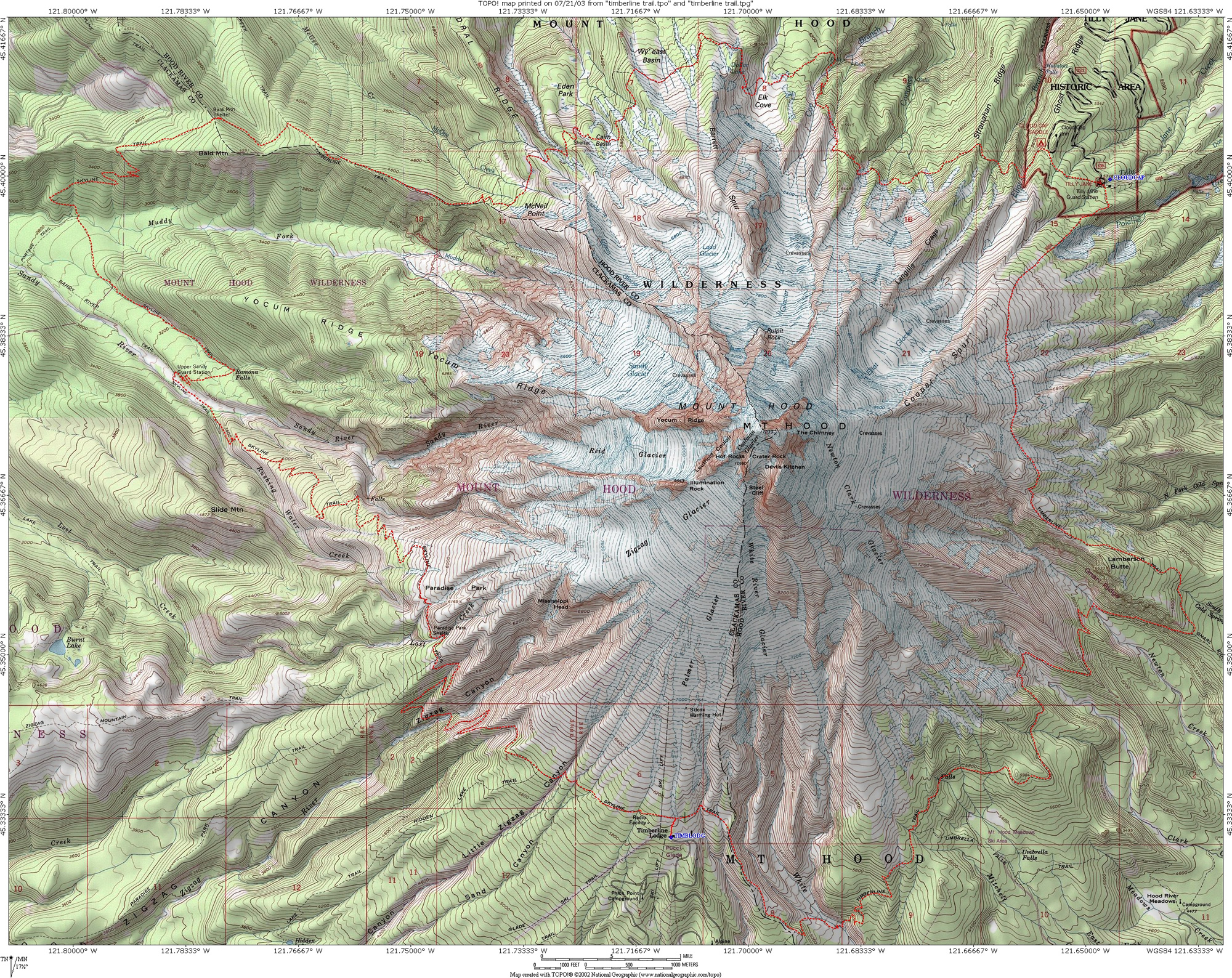
Trail Elevation Profile 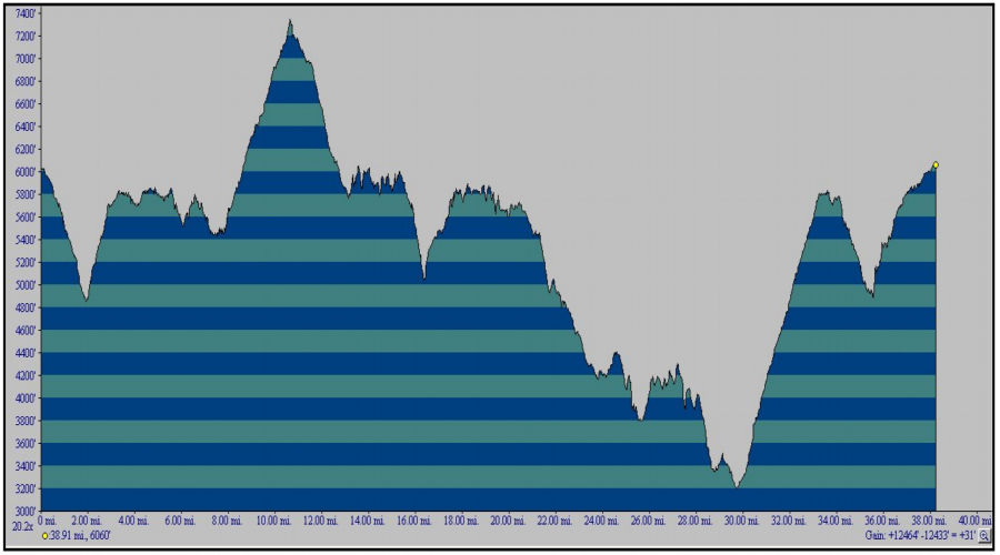
Timberline Trail Topo TPG File for use with TOPO software.
Timberline Trail using the Cutoff Trail .gpx File for use with compatible software.
Section One: Timberline to Ramona Falls.
Alternate Route Through Paradise Park
Section Two: Ramona Falls to Cairn Basin.
Section Three: Cairn Basin to Cloud Cap.
Section Four: Cloud Cap to Elk Meadows.
Section Five: Elk Meadows to Timberline Lodge.