Indian Beach Trail, OR
Notice: 2/6/2026 – Ecola State Park, including the trail to Indian Beach, is closed until further notice due to active landslides and road damage, effective December 15, 2025.
Vicinity Location:
68 miles northwest of Portland in the Tillamook State Forest.
Directions:
From Portland, take Highway 26 West to Highway 101. Take the Highway 101 South exit towards Cannon Beach.
Drive about 3 miles and take the first exit for Cannon Beach and drive about .3 mile to the stop sign. Take a right and follow the signs to Ecola Beach State Park.
Drive about 1.6 miles along the narrow, winding road through the forest to the entrance of the park. Buy your permit here if you don’t have one, then turn left after the entrance booth and drive about .2 mile to the parking lot.
Restrooms at the trailhead, Indian Beach, and Hiker’s Camp.
$5 daily permit or $30 annual permit needed to park at the trailhead.
Note: No overnight parking is allowed in the park.
Length and Elevation:
9.5 Miles round trip. Elevation gain 1,971 feet and 1,070 feet of loss one way. Total gain and loss is 2,715 feet. Elevation at the trailhead is 200 feet, the high point of the trail is 1,200 feet.
Trail:
Indian Point Beach Trail, Clatsop Loop Trail, Oregon Coastal Trail (OCT). There is a geocache at: N 45° 56.581 W 123° 59.082 Info at Geocaching.com.
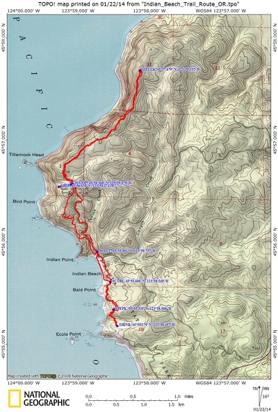
Trail Maps:
Topo Map, State of Oregon Map, Download Garmin .gpx file
Review: January 20th, 2014.
This trip is mainly an out and back trail with two sections that have an alternate return route.
A gravel path leads off to the right from the west end of the parking lot. Drop down a small hill, cross on a bridge over a small creek, and enter the woods.
The trail starts climbing somewhat steeply up a few switchbacks up to the first viewpoint of the ocean. The forest here is a mainly a mix of hemlock, Douglas Fir, and Sitka Spruce.
Continue climbing through the forest, gaining 200 feet in the first .3 mile. From there it begins to follow the rolling headlands towards Indian Point Beach. This section of the trail has some muddy patches in the low spots.
After walking about .6 mile, the trail becomes much muddier and rudimentary and will be very muddy during the rainy season. The clay in the soil makes for slippery spots as the trail traverses little fingers of land reaching towards the sea.
At just under .8 mile is a trail junction that drops steeply down to Indian Point Beach. If you see a nice strip of sandy beach, you may want to drop down and walk the beach to the parking area for Indian Point Beach. If not, turn right and continue under the base of a small cliff and around a corner, then dropping down and climbing again along the narrow trail.
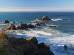
Drop down and cross on a bridge over Canyon Creek, then walk up to the parking lot. Indian Point Beach The crescent shaped beach is very inviting and there are nice views of haystack rocks to the south. Stop and linger for a bit, soaking up the sights and sounds of the beach. There is no tapwater in this area of the park.
To continue, walk towards the restrooms, then walk along the left side of them.
After a couple hundred feet, there is a junction to the left for the Clatsop Loop. Continue straight uphill into the forest.
The trail climbs steadily above the bubbling Indian Creek, then loops over the creek and leaves it behind in a wide sweeping turn, continuing steadily uphill. The forest floor here is covered in sword ferns, salal, and trees that have fallen down over the ages to become nurse logs for a new generation of the forest. On a sunny day, only dappled light penetrates the thick canopy of trees that gently sway in the ocean breezes.
After climbing steadily for about 1.5 miles, you come to the Hiker Camp. Continue straight, walking past the restroom. Heading downhill, you’ll pass a tiny spring and stream. After about .1 mile there are some concrete bunkers built in World War II. From here the trail becomes less maintained and soon comes to a nice overlook of the Tillamook Rock Lighthouse. Building and maintain the Tillamook Rock Lighthouse has been challenging. The top 30 feet of the rock had to be blasted off to build the lighthouse and storm-tossed boulders have broken windows and damaged the roof.
Venture back to the camp to see the Adirondacks. At the east edge of the camp, the trail goes off to the left. You’ll pass a couple of low spots that are muddy after rainy days, then turn to the left and walk on a short section that is nicely graveled.
The trail quickly changes from the gravel track to a rooty, rocky, rutted path as it switchbacks up the side of Tillamook Head. There are few good views as you heading north from the Hiker’s Camp. From the top of the head, there are short boardwalks over most of the muddy spots and just short muddy spots to walk through.
The trail winds through the forest, staying fairly level as it gently rises and falls along the contours of the coast.
About .4 mile from Clark’s Mountain, above the trail on the left, there is a great example of a clothespin tree. There is a gap in the roots big enough to crawl through. The tree was logged years ago and you can see the slots the lumberjacks cut into the trunk to wedge in the springboards they stood on to saw through the tree. There are several example where the lumberjacks cut slots for springboards into the trees to cut them down but there are still some old growth trees along the trail.
You’ll need a gps to know when you reach Clark’s Mountain. It is a treed knoll without a view. Just to the left of the trail are some nice little areas where you can sit and take a break and listen to the sound of the wind in the trees and of the ocean far below.
Clark’s Mountain is about 5 miles from the trailhead and it is at an elevation of 1,200 feet. There is 1,971 feet of ascent and 1,070 feet of descent to this point. If you don’t have a GPS, there is a large tree that looks like it is across the trail. The trail goes beside the tree and drops down a bit, going over some boardwalks. In about 100 feet is a toppled tree with the roots now rising vertically about 12 feet above the trail. This is the only place on the trail where you brush by this root ball. Check out the last two photos in the gallery.
Clark’s Mountain is a good point to turn around because there really aren’t any good views of the ocean north of this point.
Retrace your steps back over the boardwalks and the roots and the rocks. Once you reach the section of nicely graveled trail, you’ll know you are almost back to the Hiker’s Camp. Follow the trail back into the camp and take some time to admire the workmanship on the cedar Adirondacks.
William Clark wrote down his impressions of this area after coming here from Ft. Clatsop in January 1806. Most of the trees in the area were about 100 years old but there were much older trees that had survived some natural disaster. His journal entry of January 8, 1806 stated “The mountains, covered with a very heavy growth of pine and fir, also the white cedar or arbor vitae and a small proportion of black alder. This alder grows to a height of 60 or 70 feet and 2 or 3 feet in diameter. Some species of pine or fir on top of the point of view (Tillamook Head) rise to the immense height of 210 feet and from 8 to 10 feet in diameter and are perfectly sound and solid.”
From the camp, return via the Clatsop Loop Trail. To take this route, go just past the bathroom and take the trail that leads off to the right. The Clatsop Loop Trail switchbacks down the hillside and then crosses a small meadow and muddy patches before coming to a nice viewpoint of some haystack rocks in the ocean. There are scrubby pines and salal along this section and the salal would quickly engulf the trail if there was no maintenance.
Coming back, you can walk down to the Indian Point Beach and follow the shoreline south for about .5 mile. Look for a break in the cliffs and a dirt path leading steeply away from the beach. Follow this steep trail and rejoin the main trail and turn right to continue heading south.
Be careful on this next section of trail because some of the wood steps aren’t level and can be very slick.
Lewis and Clark stayed in this area in 1806 and they complained about the incessant rain during the winter. You, however, have the luxury of choosing to come here on a sunny or cloudy day when the emerald green of the forest is very peaceful and a nice change from the gray days of winter.
This trail can be hiked at any time of year. There aren’t many wildflowers along the trail to be seen. This trail is good for dogs but there are cliffs. Parts of this trail aren’t good for children because of cliffs, steep slopes, and slick sections of trail. State Park regulations say dogs to be leashed on trails.
Enjoy the Photos!
Gallery Pics
Switchback Steve