Sisters – Camp Lake, OR
Note 2/14/2023: During summer and fall a Central Cascades Wilderness Permit is required. The Central Cascades Wildernesses limited entry system began May 22, 2020 and brings day-use limits to 19 out of 79 trails and overnight limits to all trails in the Mt. Jefferson, Mt.
Washington and Three Sisters Wilderness.
Vicinity Location:
The Pole Creek Trailhead is about 83 miles Southeast of Salem OR, and about 102 miles Southeast of Portland, OR, in the Deschutes National Forest.
Directions:
Pole Creek Trailhead: From Sisters, Oregon, drive to the Southwest side of town and find Forest Road 15. Head west, then southwest on Forest Road 15 for about 10 miles and follow the signs for the Pole Creek Trailhead and park in the dusty parking lot.
A Northwest Forest Pass is required to park at this trailhead.
The trail enters the Three Sisters Wilderness Area shortly after leaving the trailhead.
Wilderness Permits are required for both day-use and overnight travel in the Wilderness from Memorial Day Weekend until Oct. 31. The permit box has been removed for 2020. In 2021 an advance reservation permit system will be in place to limit visitors.
Link to Three Sisters Wilderness Area Camping and hiking regulations.
An outhouse is at the parking lot.
Length and Elevation:
Elevation at the trailhead is 5,340 feet. Total distance is 49.0 miles. Highest point is 7,493 feet, lowest point is 5,340 feet. Total ascent is 8,540 feet and total descent is 8,540 feet.
| Itinerary | Mileage | Camp Elevation | Ascent | Descent | Notes |
| Day 1 – Pole Creek to Camp Lake -Started 7:30 am – Finished at 12:30 pm | 9.9 | 5,340 | 2,074 | 562 | Parked at Pole Creek Trailhead the night before. Park down a side road and away from the trailhead for a quiet night. Elapsed time 5 hours. |
| Day 2 – Camp Lake – Sawyer Bar – Started 7:45 am – Finished at 6:35 pm | 15.7 | 6,474 | 2,472 | 2,867 | Elapsed time 10:55 hours |
| Day 3 – Sawyer Bar to North Matthieu Lake – Started 7:30 am -Finished at 12:30 pm | 10.5 | 5,767 | 2,324 | 3,018 | Elapsed time 5 hours. |
| Day 4 –North Matthieu Lake to Pole Creek – Started at 7:35 am – Finished at 1:45 pm | 12.8 | 6,484 | 1,663 | 2,119 | Elapsed time 6:10 hours. |
| 49.0 | 8,533 | 8,566 |
Download food menu and itineraries in Excel here
Trails:
Pole creek Trail, Green Lakes Trail, Camp Lake Trail, Pacific Crest Trail, Matthieu Lakes Trail with connections to other trails.
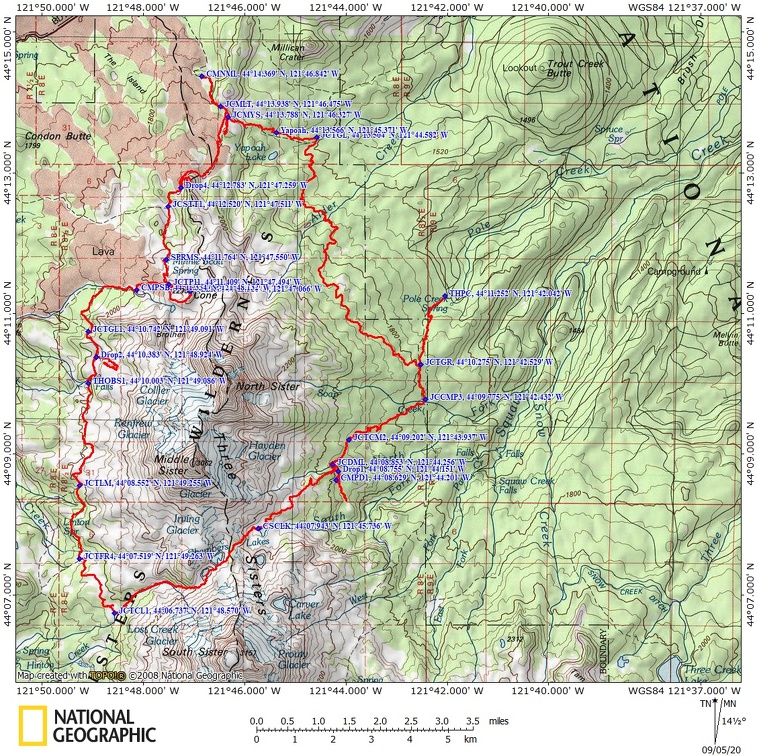
Trail Maps:
Topo Map, Download Garmin .gpx file, Open Garmin .gpx file
Review: August 8, 2020 through August 12th, 2020
Day 1 – Pole Creek to Camp Lake
5 hours Ascent 2,074 feet, descent 562 feet, 10 miles. Start elevation 5,300 feet.
Sean and I drove separate cars and met for dinner in Sisters and ate dinner at the Village Inn Park. The park has a nice lawn, picnic tables and a bathroom. From there we drove the washboard road to Pole Creek Trailhead to stay the night and get an early start. We had a couple of beers before bed and the pit toilet was close by. We parked near the trailhead which was a mistake. People came early and woke us up.
The next morning was cool and clear and we brought extra water for breakfast because there is none near the trailhead. The map shows Pole Creek Spring nearby but upon investigation we found it was dry and looks like it rarely, if ever, flows. It didn’t take long to eat, pack, and hit the trail. We started about 7:30 am and walked for the first 2 hours or so through landscape burned by the Pole Creek Fire in 2012.
You climb up a dusty, rocky trail until with the sun beating down on you. At the Green Lakes Trail junction, we turned left and dropped, then climbed, to the Camp Lake Trail junction, which is at a stream crossing. We continued uphill and after a while found the welcome shade of pines, noble first, and hemlock trees.
More climbing and two easy stream crossings before the junction to Demaris Lake. We dropped our packs at the high point of the trail to Demaris Lake and went downhill to Demaris Lake. The small lake is pretty but there aren’t many mountain views. We did some scouting and found campsites above the cliffs but with the future permit system I doubt these sites will be used much in the coming years.
Back at the Demaris Lake junction we continued uphill on the steepening grade and stony switchbacks climbing higher and higher., The trees thin and the mountains come into view. Distant vistas to the east appear as you continue to climb. After a mile or so, the climb gentles and after going about 9 miles the trail drops down a bit to the lake.
Camp Lake has several sites scattered around. Heading towards the far end of the lake is best to avoid the stronger winds. The lake is sandy gravel and great for wading or soaking your feet. The east end of the lake has a lovely pebble beach. If these sites are all full there are a few sites on the north side of the trail to Chambers Lake. You have to climb a few hundred feet above Camp Lake and look on the right side of the trail. We found one site about 00 feet off the trail and two more sites about 500 feet off the trail. You might have to melt snow for water but there was snowmelt in the afternoon.
Day 2 – Camp Lake – Sawyer Bar
11 hours Ascent 2,472 feet, descent 2,867 feet, 15.7 miles. Start elevation 7,000 feet, Camp elevation 6,474 feet.
The sun rose through smoke to the east and illuminated South Sister. The wind was calm and I got some nice pictures of South Sister with Camp Lake in the foreground. We had breakfast, packed, and hit the trail about 7:30 am.
Heading west you soon start a very steep climb up a ridge spine which barely switchbacks up a gravelly trail. After about a 500 climb the trail climbs moderately steeply through stunted mountain hemlock and pines.
After about 0.7 mile you top a pass with a great overlook of Chambers Lakes. We dropped down on a rubbly trail to the lakeshore then route find up to the next lake. From the next lake start dropping steeply down sections of rubbly rail and steep forested slopes. There was only a trickle of water popping out of the creekbed in a couple of spots.
Eventually the trail becomes a moderate descent then passes along a long rocky plain with scattered flowers. As you drop down again there are incredible fields of lupin blooming in August. The scent of lupines fills the air as you walk through the meadows.
Join the PCT at Reese Lake and stop for a swim if you have the chance. It is a delightful swimming lake and has great views of South Sister. In august the shoreline had hundreds of California Tortoiseshell butterflies. Turn right to head north on the PCT and pass by wildflower meadows, pumice plains, and forests. After a few hours reach Obsidian Falls which is a delightful waterfall next to the trail.
Continue up the trail to a cutoff to Arrowhead Lake. The GPS track for this hike cuts off earlier than the signed user trail and is just as easy with less elevation change. If you can plan ahead be sure to get a permit to camp in the Obsidian Management area at either Arrowhead Lake or where the White Branch River crosses the PCT. Arrowhead Lake is a bit of a climb on a primitive trail and is a beautiful swimming lake with great mountain vistas. Walk north about 100 feet to the cliff edge for more fantastic views.
Back on the PCT you’ll cross the White Branch River in about a mile. In summer and fall this is your last water until Minnie Scott Spring. We didn’t have an Obsidian camping permit so we had to continue to Sawyer Bar, which was completely dry. We each took about 3.5 liters of water for dinner, breakfast, and backpacking the next day. The forest and trail are both pretty but going to Sawyer bar is a long day with a climb at the end of the day. On the plus side we had Sawyer Bar to ourselves and got a great site overlooking the jagged lava flow. I walked up the gravel streambed about a quarter of a mile to catch the sunset and see it light up South Sister.
There is one more water supply ahead at the white Branch River.
Day 3 – Sawyer Bar to North Matthieu Lake
7 hours Ascent 2,324 feet, descent 3,018 feet, 10.5 miles. Start elevation 6,474, Camp elevation 5,767 feet.
We had breakfast, mixed some electrolytes and broke camp about 7:45am. We started immediately up a desolate, rugged lava flow, switchbacking up and up to Opie Dilldock Pass. It was nice to climb up to the pass early in the morning because we were mostly in the shade of the towering terrain. This area gets blasted by the afternoon sun. More fantastic views of the ancient lava flows that gushed out of Collier Cone about 1,600 years ago.
At the pass we stashed our packs and Sean got out his daypack for the side trip up Collier Cone. We took the diagonal slash that hikers have cut into the black cinder slope and were soon far above the PCT. The trekking poles were great to help balance and push up the loose terrain.
When we got to the top, we had fantastic views of the Three Sisters and many mountains to the west and north. I checked and found Verizon has good cell service here and I texted an “all is well” to my wife.
We followed along the curved ridge of Collier Cone to an overlook of two glacial lakes beneath Middle Sister. We continued along the top edge of the cone and went down the user trail back to the signed junction with the PCT.
It was an easy hike of about 0.6 mile to Minnie Scott Spring. This is a reliable place to fill up on water because there isn’t any more water until South Matthieu Lake near Scott Pass a little over 3 miles away. The springs are a welcome place to rest and have a snack. I’ve always drank straight from the spring but many people prefer to filter their water.
We headed back into the forest and descended to another beautiful meadow full of flowers then climb again up to Yapoah Crater where we stashed our packs again for another crater climb. All through here there were hundreds of California Tortoiseshell butterflies flying by us on the trail and where we stashed our packs.
We hiked around the crater rim, again with fantastic views and Verizon cell service. One large outcropping of lava has Sulphur mixed into the rock. The reds and yellows around the crater are pretty vivid.
We came back down and had lunch under the trees with the butterflies. Continuing along the trail crosses another ancient lava flow. This time the trail builders moved the lava rocks out of the way to get down to dirt and you walk through a furrow in the landscape. The amazing views along the trail continue all the way to South Matthieu Lake where you enter back into thick forest. We continued through Scott Pass and downhill to North Matthieu Lake. These lakes are in a management area with designated campsites. I suspect these are always full on summer weekends but we got our pick of sites at North Matthieu Lake. We got to the lake about 12:30, set up camp on the north side of the lake, and went for a swim. The lake is cold but good to swim in. Some parts of the bottom are muddy there are some nice places to sit along the shore.
Later in the afternoon I walked north on the trail which drops down fairly steeply and checked out a small lake along the trail. There was a campsite across the trail on the left side by the lava flow. The lake would work to filter water from but it was too marshy to swim in. Walking a bit farther the trail enters the burn from the 2006 Lake George fire and the trail has been rerouted away from a small meadow. Heading back to camp we had dinner in a day use area next to the lake. The spot was fairly sheltered from the wind and had a great view of the lake.
Day 4 –North Matthieu Lake to Pole Creek
After breakfast I went for a morning swim then met Sean back in camp. We each took about 2 liters of water because there is no water until Alder Creek. We climbed the trail back to Scott Pass, passed South Matthieu Lake, turned left onto the Scott Pass Trail #4068, and dropped our packs at the user trail to an overlook. It is an easy walk up the cinder slope and there are great views from the wind-blasted crest of the hill.
Back on the trail we dropped down through the forest and it wasn’t long before we entered an area burned in the 2006 Lake George fire. We dropped down to a flat area where I had hoped to find a user trail to Yapoah Lake but I only saw lots of dead standing and fallen trees and we didn’t want to go off trail. We continued through the burn area to the junction for Green Lakes Trail #4070 and it is hard to tell but you soon pass into the area burned by the Pole Creek fire in 2012.
Continue through the burned area, mostly climbing, to the green oasis at Alder Creek. This is a lovely steam tumbling down the hillside and across tiny clearings. There are a few campsites here which also make sweet places to have a snack and enjoy the water and wildflowers.
Revitalized we worked our way up about 600 more feet over the next two miles to some views of North Sister and east towards Sisters before dropping down to the junction for Pole Creek Trail where we turned left and were soon back at the cars.
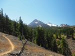
Enjoy the photos!!
Gallery Pics
Switchback Steve