Timberline Trail |
||||
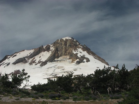 |
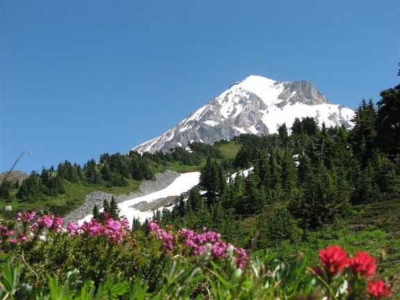
Beautiful Mt. Hood is located east of Portland Oregon |
 |
•Mt. Hood Wikipedia |
|
| Timberline Trail Mileage Table | Mileage Printable Table Metric Printable Table | Excel Download | |||
|---|---|---|---|---|---|
| Landmark | CCW (miles) | CCW w/Paradise Park (miles) | CW (miles) | CW w/Paradise Park (miles) | Elevation (feet) |
| Wy-East Lodge | +0.1 | +0.1 | +0.1 | +0.1 | 5897 |
| Timberline Lodge | +0.1 | +0.1 | +0.1 | +0.1 | 5940 |
| Begin/Finish Timberline Trail | 41.5 | 42.5 | 0 | 0 | 6042 |
| Jct. Hidden Lake Trail #779 | 40 | 41 | 1.5 | 1.5 | 5703 |
| Cross Zig Zag River | 38.1 | 39.1 | 3.4 | 3.4 | 4774 |
| S. Jct. Paradise Park Loop Tr.#757 | 37.8 | 38.8 | 3.7 | 3.7 | 4926 |
| Jct. Paradise Park Tr.#778 | 37.3 | 38.3 | 4.2 | 4.2 | 5238 |
| N. Jct. Paradise Park Loop Tr.#757 | 35.4 | 35.3 | 6.1 | 7.2 | 5465 |
| Ramona Falls | 31.4 | 31.4 | 10.1 | 11.1 | 3444 |
| Muddy Fork Crossing | 28.3 | 28.3 | 13.2 | 14.2 | 4134 |
| Jct. Cutoff Trail and PCT | 26.8 | 26.8 | 14.9 | 15.9 | 4300 |
| Jct Bald Mountain Trail | 26.1 | 26.1 | 15.6 | 16.6 | 4269 |
| Jct. Cutoff Trail and PCT | 25.4 | 25.4 | 16.1 | 17.1 | 4300 |
| Cross McGee Creek | 23.2 | 23.2 | 18.3 | 19.3 | 5440 |
| Cairn Basin Shelter | 22 | 22 | 19.5 | 20.5 | 5635 |
| Jct Vista Ridge Tr.#626 - Wy'East Basin | 20.8 | 20.8 | 20.7 | 21.7 | 5802 |
| Jct Elk Cove Tr.#631 | 19.5 | 19.5 | 22 | 23 | 5457 |
| Cross Eliot Creek | 14.6 | 14.6 | 26.9 | 27.9 | 5460 |
| Cloud Cap Camp | 14 | 14 | 27.5 | 28.5 | 5856 |
| Cooper Spur Shelter | 12.7 | 12.7 | 28.8 | 29.8 | 6779 |
| Cross Lamberson Spur | 11.3 | 11.3 | 30.2 | 31.2 | 7330 |
| Jct. Gnarl Ridge Tr.#652 | 8.5 | 8.5 | 33 | 34 | 5632 |
| Jct. Newton Creek Tr.#646 | 7.6 | 7.6 | 33.9 | 34.9 | 5592 |
| Cross Clark Creek | 6.1 | 6.1 | 35.4 | 36.4 | 5513 |
| Jct. Umbrella Falls Tr.#667 | 3.7 | 3.7 | 37.8 | 38.8 | 5756 |
| Cross the White River | 2 | 2 | 39.5 | 40.5 | 4934 |
| Exit the PCT begin Tr.#600 | 1.4 | 1.4 | 40.1 | 41.1 | 5308 |
| Begin/Finish Timberline Trail | 0 | 0 | 41.5 | 42.5 | 6042 |
| Side Trip to Elk Meadows | CCW (miles) | CCW w/Paradise Park (miles) | CW (miles) | CW w/Paradise Park (miles) | Elevation (feet) |
| Jct. Gnarl Ridge Tr.#652 | 0 | 0 | 0 | 0 | 5632 |
| Elk Meadows Shelter | 1.3 | 1.3 | 1.3 | 1.3 | 5037 |
| Jct. Gnarl Ridge Tr.#652 | 2.6 | 2.6 | 2.6 | 2.6 | 5632 |
One of the best ways to experience Mt. Hood might be to grab yourself some of the software I use and map out some cool trails to explore.
CalTopo is web based; Viewranger has smartphone and web based applications; Gaia has smartphone and web based applications. Garmin has proprietary PC software and dedicated devices.
Timberline Trail Topo Map with entire route.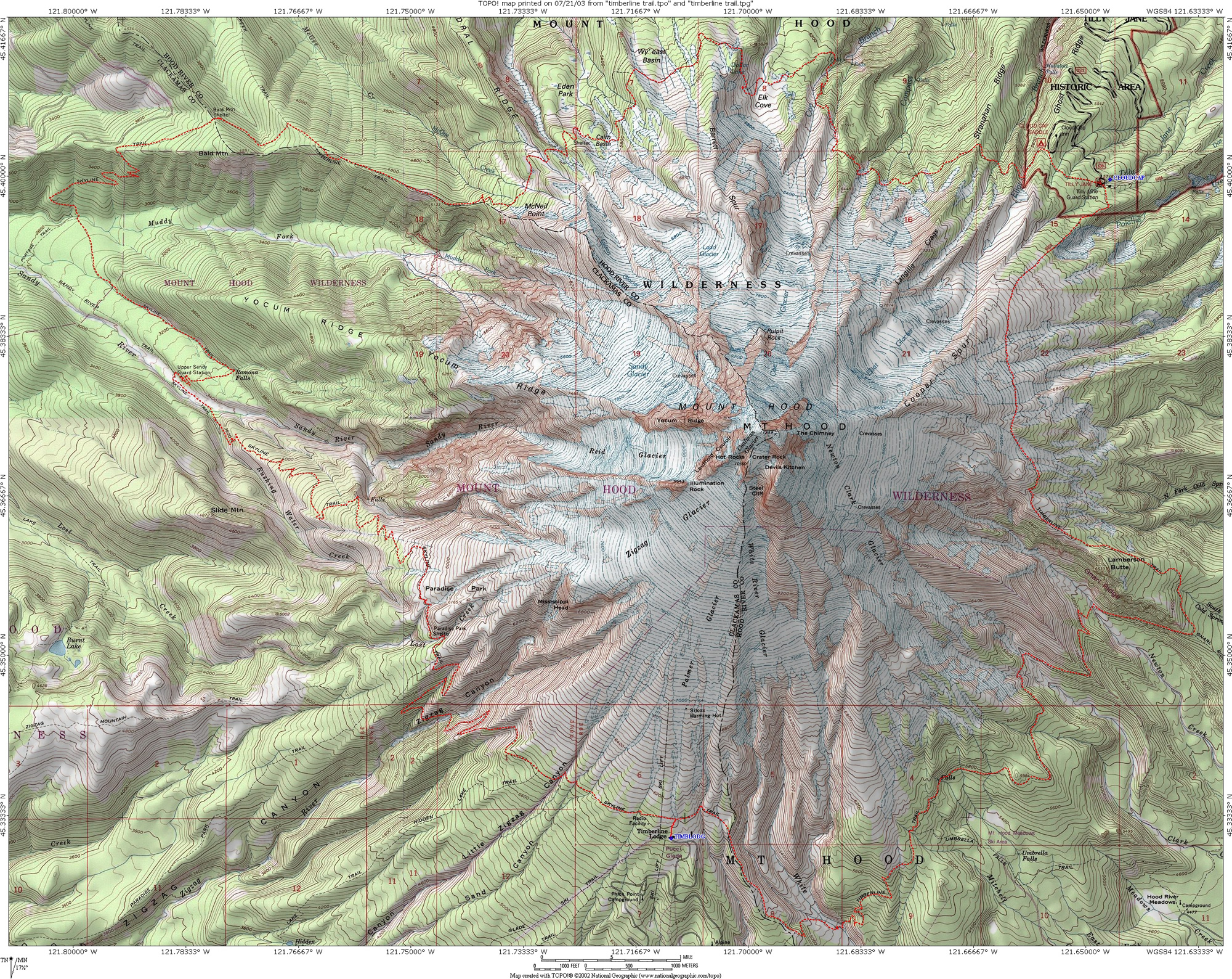
Trail Elevation Profile - CCW 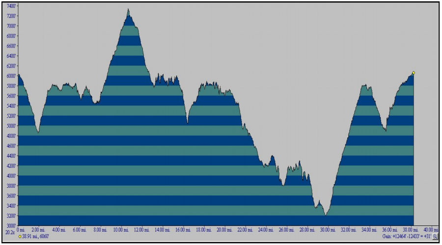
Timberline Trail Topo TPG File for use with TOPO software.
Timberline Trail .gpx File for use with compatible software.
Section One: Timberline to Ramona Falls.
Alternate Route Through Paradise Park
Section Two: Ramona Falls to Cairn Basin.
Section Three: Cairn Basin to Cloud Cap.
Section Four: Cloud Cap to Elk Meadows.
Section Five: Elk Meadows to Timberline Lodge.