
Vicinity Location:
About 15 miles east of Ashford, WA in Mt. Rainier National Park.
Directions:
The road to this trailhead is generally closed from November to May. Check the Mt. Rainier National Park website for the Stevens Canyon Road opening and closing dates.
From Portland, take I-5 North and take exit 68 to Hwy 12. Take Hwy 12 for about 30 miles to Morton. Turn left on Hwy 7 and drive about 17 miles to Hwy 706. Turn right on Hwy 706 and drive to the Nisqually entrance on the west side of Mt. Rainier National Park. Continue several miles past Longmire Inn turn right towards Stevens Canyon Road. Continue ½ mile past Reflection Lakes and park in the parking are on the right (south) side of the road.
From Seattle, take I-5 South to Hwy 512 East and go towards Puyallup (Exit 127). Follow Hwy 512 East for about 2 miles. Turn south onto Hwy 7 towards Mt. Rainier. Follow Hwy 7 south to Elbe. At Elbe, turn left onto Hwy 706, travel through Ashford, and then to the Nisqually entrance of Mt. Rainier National Park. Continue several miles past Longmire Inn turn right towards Stevens Canyon Road. Continue ½ mile past Reflection Lakes and park in the parking are on the right (south) side of the road.
No outhouse is available at the trailhead.
Pets aren’t allowed on National Park trails.
Parking is an issue on nice weekend days. The rangers may ticket motorists who are parked along the road and not in the parking lot.
National Park Entrance fee of $30.00 for a car or $25 for a motorcycle and a single passenger or Annual Pass is required to enter the park.
Length and Elevation:
3 Miles roundtrip. Trailhead elevation is 4,535 feet. Elevation gain and loss totals 800 Feet
Trail:
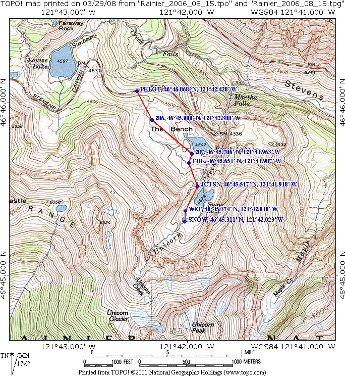
Bench Lake/Snow Lake Trail.
The trailhead sign may be removed for winter storage early spring and late fall.
Pets, bicycles and saddle/pack animals are not allowed on trails in the National Park.
Trail Maps:
Topo Map, National Park Map, Download Garmin .gpx file
Review: September 27, 2005, August 15th 2006, July 12 2014
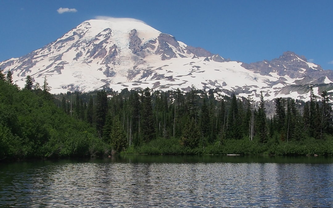
This is one of the more popular trails in the park and is well maintained. The trail crosses a small stream and climbs to a flat area with views of a “sliver forest” and Mt. Rainier. This area has spring flowers and great fall colors. After a couple more little hills, you reach an overlook of Bench Lake. Bench Lake’s name comes from the area around the lake, which is called “The Bench.” If you want to go for a swim, this lake is shallow and is fairly warm. At least think about wading along the shore for a bit for a great view of Mt. Rainier.
Continue over another ridge and the trail branches just before Snow Lake. Snow Lake Camp is to the left and across a logjam. To the right is a trail to the west end of the lake with breaks in the trees to give you views of the turquoise lake.
Most years Snow Lake doesn’t melt out until late July and snow lingers at the west end of the lake even later into the year. Walk to the west end of Snow Lake and explore the snowfield and the winter avalanche debris. Listen for underground streams running on the southwest side of the lake.
This is a great trail for small children. There is only one place where there is a large dropoff near the trail. Some caution should be taken on the steep downhill sections because the trail is usually slippery. Be cautious because black bears are seen in this area.
Enjoy the photos!!
Gallery Pics
Switchback Steve
Recent Comments