

Vicinity Location:
About 87 miles northwest of Portland, OR at Cape Disappointment State Park.
Directions:
Take I-5 North from Portland and drive about 43 miles.
Take exit 36A-36B for WA-432 W/Kelso Dr toward Airport/Talley Way. It is easy to miss this exit.
Continue for 4 miles onto WA-432 W to the stoplight at Oregon Way and get into the left turn lane.
Turn left onto Oregon Way and drive for about 50 miles to Astoria, crossing over the Columbia River.
In Astoria turn right onto US-101 N and drive for 15.4 miles, crossing the Astoria-Megler Bridge and continuing on US-101 N to Ilwaco, WA.
Turn left onto 2nd Ave SW and drive on WA-100 S to the gravel parking lot near the gift shop and just before the paved boat launch parking area.
A Washington Discover Pass is required to park here.
Bathrooms at the nearby boat launch.
The trail starts at the parking lot across from the gift shop and store.
Length and Elevation: 1.7 miles roundtrip. Elevation at the trailhead is 24 feet. Total gain is 290 feet and loss is 290 feet. Highest elevation is 100 feet and the lowest elevation is 24 feet above sea level.
Trail:
Coastal Forest Loop Trail
There are no geocaches on this hike.
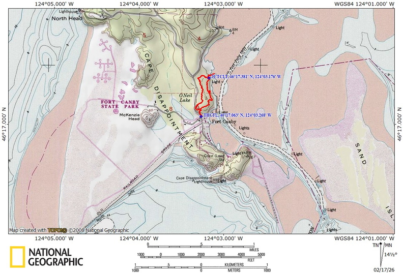
Trail Maps:
Topo Map, Map and Interpretive Trail Guide, Download Garmin .gpx file, Open Garmin .gpx file
Review: September 3, 2024
To begin you go fairly steeply uphill into a forest mainly of alder and Douglas fir trees.
This part of the trail has a undergrowth mainly of sword ferns and some elderberry trees.
Soon you come to a set of stairs that was constructed by Washington Trails Association the stairs stop the trail erosion in this area and make it easier to get up the hill.
You soon reach a sign with an arrow, pointing to the right making this a directional trail. Continue climbing up the hill and the trees begin to change to larger Sitka, spruce trees, and Alder trees.
At 2/10 of a mile, you make a you meet a trail junction where you can turn left and just follow the half mile back to the parking lot or continue ahead for a nice view of the bay and the trail drops back down the hill.
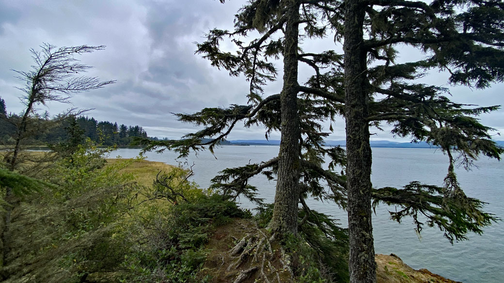
At 0.6 miles you go through a small but deep gully and then climb up to a wooden bench to take a rest on and a trail junction where the right junction leads to an overlook of the bay and the left continues on through the trail.
There are red elderberries and salmon berries growing 10 to 15 feet high in this area.
The short side trail leads to a rooty and bad little section of trail to an overlook of the bay. Watch out for cliffs along this section of trail.
At about 0.9 mile into the trail you come to some really big Sitka spruce trees. One off to the left of the trail is truly massive.
Add about a mile the trail starts climbing back up the hill passing more, old growth Sitka, Spruce, and hemlock trees
Climbing up the hill at 1.2 miles you pass the junction for the short loop trail. Continue to the right through the forest to finish your hike.
The trail is somewhat rooty in places, but it did not seem muddy. There are some old planks over the wet sections of the trail and muddy spots have been replaced or repaired with timber stair boxes filled with gravel and a culvert.
A little more than a mile you’ll come back to the Trail Junction back to the parking lot where you turn right and head down the hill to the parking area.
This trail is safe for dogs and small children, except for the overlook trail, which has some cliffs along it.
Enjoy the photos!!
Gallery Pics
Switchback Steve
Recent Comments