
Vicinity Location: The trailhead is 27 miles east of Portland, OR in the Columbia River Gorge.
Directions:
From Portland, take I-205 north past the airport and cross the Columbia River. Get into the right hand lane and take the exit for Camas. Drive about 28 miles. The trailhead is .9 mile past milepost 28. It is an unsigned parking area just past the Prindle highway maintenance building on the left side of Highway 14.
There are no bathrooms or water at the trailhead.
Length and Elevation: 12 miles roundtrip. Elevation gain 2,800 and loss 900 to the turnaround at the powerline, total 7,400 feet in elevation change. Elevation at the trailhead is 150 feet.
Trail:
Cruzatt Rim Trail
There are no geocaches in along this trail.
Topo Map, Download Garmin .gpx file
Review: June 12, 2011
Parts of this trail cross into the Columbia Falls Natural Area Preserve which is closed to the public.
The trail begins about 100 feet up a grassy gravel road from the pulloff. Look for the small foot trail going into the trees on the right. The first part of the trail consists of fist sized basalt rocks mixed in with dirt and other organic matter. You will know you’re on the correct trail because the trail crosses the hillside behind and above the Prindle maintenance shop. You can see the roof of the shop through the brush and trees.
After about .75 mile uphill the trail crosses under a powerline. The trail goes almost directly across the clearing under the powerline and re-enters the lush second-growth woods on the somewhat rocky trail. The forest on this part of the trail is a mixture of fir and alder. The out-compete much of the undergrowth leaving ferns, snowberry, Oregon Grape, and a mixture of other low growing plants. There is some vine maple but the dense canopy doesn’t allow lots of sunlight into the forest.
After climbing for about a mile you come to a rocky clearing which provides the first nice view of the gorge. As you cross the areas that are rocky and mossy, be on the lookout for poison oak because there are small poison oak plants growing in the moss. You can take a left at waypoint JCVP2 and go up to a ridge that looks up towards the basalt cliffs to the north.
In about 1.25 miles you cross an old lava flow and follow the trail back into the woods going slightly downhill. This part of the trail is pretty rocky and one could easily twist an ankle.
There are a few old growth trees scattered along this section of the trail which is surprising because parts of the trail use old logging roads. Soon the trail skirts a hillside and after about 1.5 miles comes out onto a large rock field with a great view of the Columbia River Gorge and Hamilton Mountain. It seems an oddity that there is a rockfield like this so close to the west end of the Gorge because the gentler slopes and rainfall allow the trees and bushes to grow lushly.
The trail here turns to the left and heads pretty much straight uphill towards the basalt cliffs. There are some small cairns here and there to show the way across the mossy rockfield.
Near the top of the rockfield, turn right and follow the small stone cairns back into the woods. You can be sure you’re still on the trail because the trail is cut slightly into the hillside as it enters the woods.
After about 1.5 mile you come to the first switchback and it is a very gentle grade. The second switchback gets right down to the business of climbing up the hill. Once you reach the beginning of the third switchback you can hear a small stream about .1 mile to the east. The clearing to the east is for a gas pipeline that crosses Clark County.
At JCP2 turn right and climb up several more switchbacks along Cruzatt Rim. Turn right again at the next junction and the trail shortly comes out at the gas pipeline, about 2.5 miles from the trailhead. Looking down the cleared areas you have limited views of the Gorge. The trail goes straight across the right-of-way and heads back into the woods.
About 3 miles from the trailhead the trail goes along the lip of the Gorge and you can see several hundred feet down the forested hillside. You don’t quite have views of the Gorge but have glimpses of the Columbia River and sun dappled Vine Maples.
At about 3.5 miles the trail begins to descend a bit to JCP4. This is the junction of a trail that parallels the Gorge.
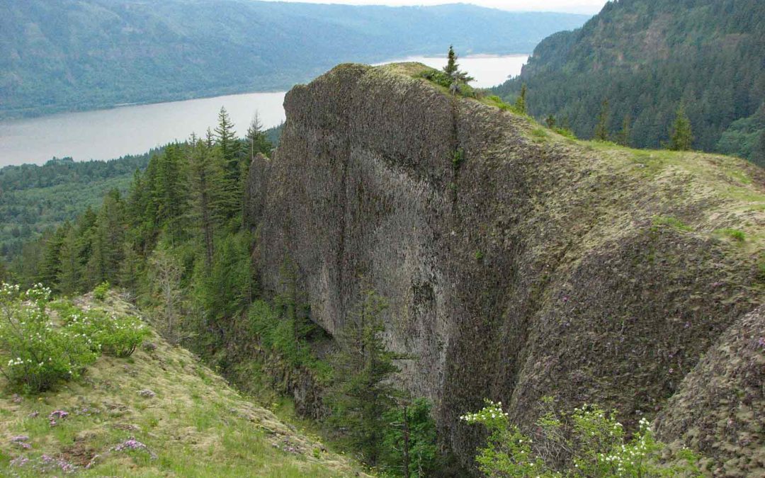
Take a tiny little trail that goes really steeply over some rocks and down the hill through the woods and it comes out to a volcanic spur that sticks out into the Gorge. This spur of stone had wonderful views of Multnomah Falls, the Columbia River to the east and west and the nearby hills. You can also see parts of Highway 14 and St. Cloud Lake to the left.
In the springtime there are lots wildflowers around including low growing phlox, wild parsley, paintbrush, service berry and Penstemon.
After the trail crosses a small stream, it goes down another abandoned logging road. The trail leaves the logging trail and becomes an animal track through the woods and meets up with another old logging road heading uphill to the east.
At about 4.5 miles the road takes a decided swing to the left. At this point, look to the right for the trail that goes off to the right into the trees. There may be a small piece of flagging marking the trail.
The track drops down and meets a barely discernible junction. To the right a short trail about 500 feet long goes out to an overlook of the creek and waterfall to the east. This narrow, sloping viewpoint is at the top of tall cliffs on a sloping hillside. From here you can see a horsetail waterfall and cliffs to the east and out across the Gorge.
Turning to the left, the track ascends for a short distance and in about .5 mile comes out to a large powerline. Heading down towards the powerline on the old abandoned logging road, memorize the way you can so you can find your way back because of the tangle of logging roads that branch off of the trail. So as you head back up, take the trail through the woods.
You can turn right and walk back towards the Gorge. Following the powerlines, you go over the hill and have views of the Gorge but not of the Columbia River. From here, walk back the way you came to the break in the trees and the trail back to the overlooks.
Wow, what a trail so close to the Portland/Vancouver area.
Enjoy the photos!
Gallery Pics
Switchback Steve
Recent Comments