

Vicinity Location:
About 54 miles east of Portland, OR in the Mt. Hood National Forest.
Note: This trailhead is inaccessible in the winter because Forest Road 44 is not plowed to this area.
Directions:
Drive south on Highway 35 towards Mt. Hood for 25.4 miles. Turn left from Highway 35 to Forest Road 44. Pay attention for this junction because it appears abruptly.
Turn left and drive east on Dufur Valley Rd/NF-44 for 8.4 miles.
Turn right onto Cold Springs Rd/NF-4420 and drive 0.9 miles to a parking area on the shoulder of the road on the left side.
There are no restrooms at the trailhead but there is a bathroom at the Flag Point lookout.
Length and Elevation:
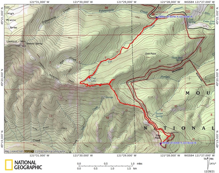
Total trip is 9.5 miles. Elevation at the trailhead is 4,585 feet. Total ascent is 2,707 feet and total descent is 2,707 feet. Highest point is at 5,810 feet. Lowest point is at 4,585 feet.
Trails:
Fret Creek Trail #456A, Divide Trail #458 with connections to multiple trails.
The trail is open to hikers and horses only.
There are no geocaches along this trail.
Trail Maps:
Topo Map, Download Garmin .gpx file, Open Garmin .gpx file
Review: November 2, 2020
The Fret Creek Trail #456A starts across from the trailhead and goes fairly steeply uphill. The trail passes through a nice forest of hemlock, larch, and grand fir trees. The fir needle covered trail winds up the hill above Fret Creek. Climb fairly steeply for about 300 feet in the first quarter mile of the trail. The understory is fairly clear because the dense forest blocks most of the sunlight. Grasses and small shrubs grow along the way.
The trail drops down a bit then climbs much more gently as it crosses Fret Creek twice, at about 0.3 and about 0.8 mile. The trail provides a few nice views of the creek as you walk above it.
The trail climbs again to where you cross Fret Creek, which is now just a trickle, for the final time at 1.4 miles. The trail gets very steep ass you approach Oval Lake 2 miles into the hike. This is a small shallow lake that doesn’t look deep enough to swim in. The lake is surrounded by hemlock and a few larch trees. The Palisades rise in the distance behind the lake. There are a couple of campsites on a sloped area and one large flat campsite just north of the lake.
At about 2.3 miles you come to the junction of Divide Trail #458 where you turn left to head towards the Palisades rock formations and the Flag Point lookout. In just 0.2 miles of climbing uphill you reach the Palisades. This is a large grouping of weathered volcanic rocks which jut above the surrounding countryside. If you climb up towards the top you have a view of four volcanic peaks, Mt. St. Helens, Mt. Rainier, Mt. Adams, and Mt. Hood. Looking off to the east is the Flag Point lookout rising above the butte. After you’ve had your fill of these wonderful views continue along the trail dropping down off the Palisades and working your way through a saddle.
The trail goes up and down through a forest of pine, hemlock, and larch, continues through a meadow, and comes to a junction of four trails. Continue through the meadow and look for the road that goes uphill to the lookout. Follow the road for about 0.5 mile to the lookout, passing a gate which is normally locked.
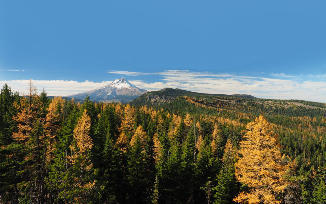
On the way back be sure to take a side trail that is just after the Douglas Trail and walk to the southwest for about 0.25 mile to Flag Point where there is a rocky clifftop meadow with incredible views of Mt. Hood and Mt. Jefferson. The yellow larches in the fall make this view even more spectacular.
Continuing back down the road from the lookout, cross the meadow there are a couple of steep climbs that you may have forgotten about. You can take some time to climb up to the highest palisade. From here there are nice views of Mt. Adams, Mt. Rainier, Mt. Jefferson, and Three Sisters. A large palisade rises nearby to the east.
Follow the trail back to the Fret Creek Trail, turn right, and venture back to the trailhead.
Enjoy the photos!!
Gallery Pics
Switchback Steve
Recent Comments