

Directions:
From Portland, take I-5 North and take exit 68 to Hwy 12. Take Hwy 12 for about 30 miles to Morton. Turn left on Hwy 7 and drive about 17 miles to Hwy 706. Turn right on Hwy 706 and drive to the Nisqually entrance on the west side of Mt. Rainier National Park. Drive about one mile from the entrance and turn left on Westside Road. Continue about three miles to the parking area and gate. This road is closed in the winter.
From Seattle, take I-5 South to Hwy 512 East and go towards Puyallup (Exit 127). Follow Hwy 512 East for about 2 miles. Turn south onto Hwy 7 towards Mt. Rainier. Follow Hwy 7 south to Elbe. At Elbe, turn left onto Hwy 706, travel through Ashford, and then to the Nisqually entrance of Mt. Rainier National Park. Drive about one mile from the entrance and turn left on Westside Road. Continue about three miles to the parking area and gate. This road is closed in the winter.
No toilet facilities. Pit Toilets are available at Kautz Creek.
National Park Entrance fee of $30.00 or Annual Pass is required to enter the park.
Length and Elevation:
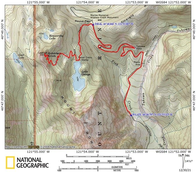
11.8 Miles total round trip. Elevation gain 2,700 feet and no loss. Total gain and loss is 5,400 feet. The road segment (including washed out portions) is 3.5 miles each way and 1,170 feet gain from the gate on Westside Road to the Gobbler’s Knob trailhead at Round Pass. The foot trail is 2.4 miles each way and 1,570 feet gain from the trailhead to Gobbler’s Knob fire lookout.
Trail:
Gobbler’s Knob Trail. Connections to Goat Lake Trail #248.
Trail Maps:
Topo Map, Download Garmin .gpx file, Open Garmin .gpx file
Review: October 13, 2007
From the parking lot on Westside road, continue past the gate on the closed road and cross Tahoma Creek on a footlog. From there, follow the flagging through the road washout. Short sections of the road in the valley are intact.
On the Topo map, the road is washed out in at least two places. Note how the forest trees have by the flood that pounded rocks against the trees. Once the flood girdled the trees they soon died. Farther up the road are dozens of deadfalls that have been chainsawed through to clear the trail.
This section of the road on the valley floor is still good for hiking or mountain biking. The road is in good shape where it heads steeper uphill and leaves the valley floor. Continue uphill to Tahoma View where there were once views of Mt. Rainier. Now second growth trees have obscured the view. Continue uphill once again to Round Pass and the Gobbler’s Knob trailhead.
At the trailhead sign is a bike rack. Mountain bikes aren’t allowed on the Gobbler’s Knob trail. Follow the well maintained trail as it winds its way up to Lake George. Lake George is a popular backpacking campground with individual sites and a group site. There is also a rustic ranger’s cabin for the Park staff.
Lake George is a somewhat narrow lake oriented towards Mt. Wow. This lake, like many lakes in the Park, can have plenty of black flies in the spring. Early spring and fall are great times to hike this trail. On the far side of Lake George is a trail that goes partially around the lake. There are several deadfalls in the trail to negotiate.
Leaving the lake, the trail becomes a bit steeper as it climbs up the slopes of Gobbler’s Knob. The trail crosses a couple of seasonal streams and passes another lake. This is the last water on the trail. Now the trail begins a series of switchbacks to the intersection of Goat Lake Trail. Many people choose to reach Gobbler’s Knob via this side trail which begins outside the Park. Please remember that pets are not allowed on trails in the Park.
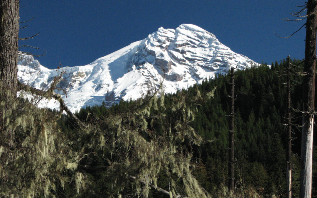
Just below Gobbler’s Knob, the trail clears the trees and you have an unobstructed view of the valley below, Mt. Rainier, and Goat Rocks. Just a bit more and you reach the fire lookout at Gobbler’s Knob. The lookout was heavily damaged in the November storm of 2006. The roof was blown off and most of the walls were knocked down. Now the lookout is mostly repaired and will be ready the summer of 2008.
Enjoy the 360 degree views from the area and look down on Lake George and the Tahoma Creek valley. You can look at your map and pick out the peaks around Mt. Rainier and the major features of the west side, such as Emerald Ridge.
From here, return to the trailhead, and if you brought your mountain bike, enjoy the fast ride downhill until you have to walk around the washouts.
Enjoy the photos!!
Gallery Pics
Switchback Steve
Recent Comments