
Vicinity Location: The trailhead is about 49 miles southeast of Portland, Oregon in the Mt. Hood National Forest.
Directions: From Portland take I-84 East to the Wood Village, exit (16A). Head south and turn left onto NE Burnside Rd. Heading East, Burnside will merge into Highway 26.
Follow Hwy 26 for 26.8 miles to Zigzag. When you drive past Welches, you are getting close to Lolo Pass Road. East Lolo Pass Road is just after the Hoodland Fire Station and Salmon River Road, which are both on the right and the Zigzag Mountain Store on the left. Turn left onto E. Lolo Pass Road.
In about 4 miles large sets of powerlines come into view and the road parallels the powerlines for the next several miles. Be careful at about 6.25 miles where there is a short gravel stretch of road and some large potholes. Watch out for holes in the road as you follow the twisty paved road for the last 4 miles. At about 10.4 miles you reach Lolo Pass. Just before where the Pacific Crest Trail crosses the road turn right onto Forest Road 1828, a single lane paved road with pavement sags and holes.
If you see the turn for Forest Road 18 then you have gone too far. Go back a couple hundred feet and turn onto Forest Road 1828.
Drive 3 miles to the junction with gravel Road 118, which is a hairpin turn to the left. You may have to stop and backup to get around the turn. Follow this route for 1.5 miles to the Top Spur Trailhead. The last mile of road is gravel and pretty rough.
The parking lot fills up and people park in the road making you get your car get scraped by bushes.
There is a seasonal bathroom at the trailhead.
A Northwest Forest Permit is required to park.
Trail:Top Spur Trail #785, Timberline Trail #600, McNeil Point Trail. Connections to the Pacific Crest Trail #2000.
There is at least one geocache for this trail at: N 45° 24.494 W 121° 47.167 Info at Geocaching.com
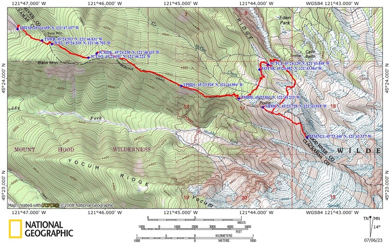
Trail Maps:
Topo Map, Download Garmin .gpx file
Length and Elevation:
10 miles round trip to McNeil Point Shelter, 11 miles round trip to Hot Rock. Elevation gain of 3,900 feet and loss of 370 feet to Hot Rock. Elevation at the trailhead is 3,940 feet. Elevation at McNeil Point is 6,020 feet. Elevation at the end of the trail near Hot Rock is 6,870 feet.
Review: August 7, 2011, July 3, 2023
Just a few feet from the trailhead is a plaque for Judge Jonathan Newman 1927-1991 and a nice picnic table. The beginning of this trail is deeply rutted and climbs over rocks and roots. The trail starts in a nice forest of Douglas Fir and immediately starts climbing.
After walking about .4 mile the trail passes the new Mt. Hood Wilderness boundary. Congress passed a law March 30, 2009 adding about 125,000 of wilderness around Mt. Hood. Continue up the trail through the older second-growth forest for a couple hundred feet to another trail junction.
At .5 mile from the trailhead is a junction with the Pacific Crest Trail and the Timberline Trail. This is where the two trails are the same for a while. To the left the Timberline Trail #600 goes to Cairn Basin. To the right the Timberline Trail goes to the Muddy Fork of the Sandy River.
Turn left onto the Timberline Trail and you see the difference between trails that have horses and trails that don’t. In the Wilderness area parties of up to 12 people are allowed. Continue on the left and the trail drops down slightly through a forest of fir trees with Dogwood plants, or bunchberries, growing along with a myriad of other plants.
About .5 mile further is a junction to the left for McGee Creek Trail. Continue straight ahead following the trail as it climbs along the ridge through the forest of nice sized second-growth trees. As you gain elevation the amount of beargrass and other wildflowers increase. Walking uphill about 20 minutes more brings you to a nice little clearing which is a good place to take a break.
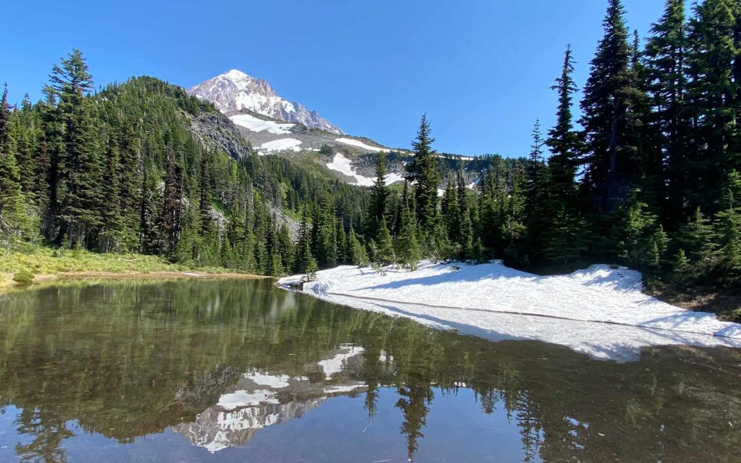
The trail continues climbing along the ridge and at VPHD1 comes out to a mountainside meadow with a spectacular view of Mt. Hood. Off to the right down in the valley is the Muddy Fork of the Sandy River.
The trail continues through the forest, crossing a seasonal stream and passing a small pond. In another .3 mile is the junction for the McNeil Point Trail. Turn right off of the Timberline Trail.
From the junction of the McNeil Point Trail, climb fairly steeply up a narrow ridge and turn right across a rockfield or snowfield, depending on the season. The trail then curves around and goes through a small mountain meadow with only the peak of Mt. Hood showing. The trail continues climbing up the slope of Mt. Hood.
The trail comes to a junction at the beginning of another mountainside meadow. The trail to the right goes lower, skirts the top of a fairly steep slope, and leads to the McNeil Point Shelter. Follow this trail to the steel-roofed stone shelter. Wander around the corner to overlooks into the Sandy River Valley. There are a couple of campsites here and a couple more scattered around the area. This area can be dry in the summer and the last streams are back near the junction of the McNeil Point Trail and the Timberline Trail. Please respect the rule of no campfires within 500 feet of the stone shelter.
On a ridgeline boulder above the shelter is another memorial plaque dedicated to Rick Smith. This is a great spot for a lunch break and it has outstanding views down the valley and up to Mt. Hood.
To continue up to Hot Rock follow the obvious trail uphill and then ascend steeply up a rut of a trail to a ridgeline. Follow the ridge up to Hot Rock, a large lava rock jutting above the ridgeline. You can go a bit further up the ridge with a view of a sharp rock spur further up the ridgeline. It is a scramble from here so this is a good place to turn around.
To return, head down back towards the shelter and turn right on a trail above the shelter to rejoin the main trail. From there retrace your path back to the trailhead being careful to remail on your track as there are a couple of dead-end trails.
An alternative route is available from the shelter down to the Timberline Trail but it is very rough and steep.
Certainly in the spring and early summer, Top Spur Trail has a lot more stream crossings to break up the walk through the forest than most of the other trails on the north side of Mt. Hood. The trail is in excellent condition for the most part, all the deadfall has been cleared out.
About a mile before the trailhead the trail climbs slightly for about .5 mile before dropping back down to the trailhead. Once back on the road there are some nice views of Mt. Hood from the road that you can see as you drive back home.
Enjoy the photos!
Gallery Pics
Switchback Steve
Recent Comments