

Vicinity Location: About 75 miles northeast of Portland, OR in the Gifford Pinchot National Forest.
Directions: From Portland: Drive east on I-84 about 58 miles and take exit Take Exit 64 for Highway 35, White Salmon, and Government Camp down to the traffic light.
At the traffic light turn left on Button Bridge Road for Bingen and White Salmon, pay the $3.50 toll, and drive 1.1 miles over the Hood River Bridge.
Turn left onto Highway 14 West and drive 1.6 miles.
Then turn right onto Highway 141 Alt for Trout Lake and the Mt. Adams Recreation Area.
Drive along the White Salmon River for 2.2 miles and turn left at the “Y” junction onto Highway 141 for BZ Corner, Trout Lake, and Glenwood.
Take Highway 141 for 19 miles to the V intersection with Mount Adams Road at the gas station. Turn right and drive 24.6 miles on Mount Adams Road which turns into Forest Road 23.
Travel on Forest Road 23 to the intersection with Forest Road 2329. Turn right on to Forest Road 2329. Drive 4.8 miles to the trailhead parking area.
No permits needed to park.
Restrooms are not available here.
Length and Elevation:
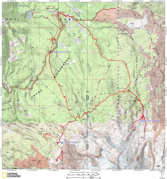
24.7 miles roundtrip. Elevation at the trailhead is 4,584 feet. Total gain is 5,362 feet and loss is 5,362 feet. Highest elevation is 6,964 feet and the lowest elevation 4,357 feet.
Trail Maps:
Topo Map, Download Garmin .gpx file, Open Garmin .gpx file
Trails:
Killen Creek Trail #113, Pacific Crest Trail #2000, Highline Trail #114, Muddy Meadows Trail #13, with connections to various trails.
Review: October 12, 2024
Start out with a moderate climb for the first couple of miles on a sandy rutted trail. There are nice colors in the fall with the different blueberries and huckleberry bushes.
A sandy trail gently climbs up to the PCT. You pass through nice open meadows with views of Mount Adams.
At 4.5 miles cross Adams Creek, which can be a hop across or there might be a log upstream. During summer runoffs this stream can be quite large.
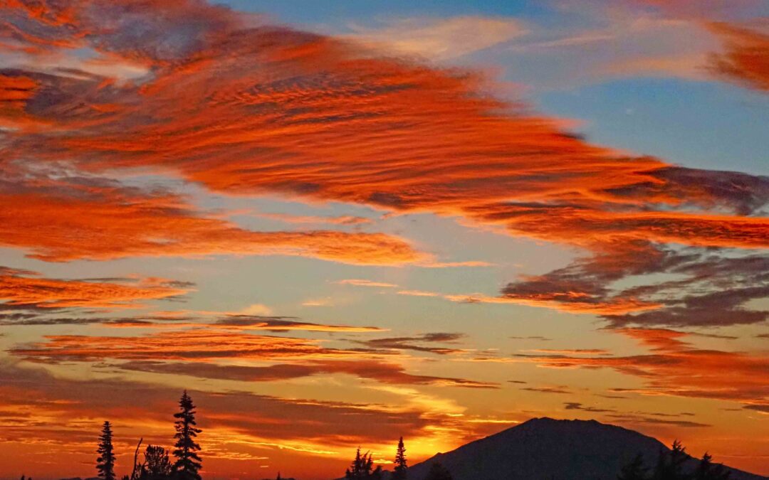
We wandered around at night and found some great views of Mount Adams, Mount Saint Helens, and Mount Rainier.
From camp, we walked down the trail back to the junction with the PCT and the Killen Creek Trail and continued north on the PCT. The trails are in very good shape and the fall colors were very pretty. You are near timberline so there are many views of Mount Adams. There was a little walkout spot with a great view of goat rocks and Mount Rainier.
You pass through the beautiful Killeen Creek Meadows, cross Killen Creek, then drop down to the junction for the Highline Trail, where you turn right and immediately start climbing up a seldom maintained trail.
The trail goes through a somewhat open forest as it climbs up along the northern shoulder of Mount Adams.
Continue ascending to Foggy Flats which is several large meadows with a swiftly running stream just past the meadows. This is the last place to get clear water for a couple of miles.
After Foggy Flats, the trail crosses the stream and climbs steeply up a rocky trail.
In about 0.5 mile the trail starts to level out and the forest begins to open up. As you continue to climb up towards the Muddy Fork, the trees become more sparse and you start getting more and more views of Mount Adams.
Just before the Muddy Fork follow the GPS track out of the valley to a spot where there are several mostly flat campsites. There are some spectacular views from some of the campsites. There is no water here except for the Muddy Fork which is very muddy and brown in color. If you need water from the Muddy Fork, then you can dip out water and let it settle a couple hours and then you have a choice of either just boiling it and using it or filtering it, but be aware this silty water will quickly clog your water filters.
There is a lot of off trail wandering available in this area. You can climb up to where there are some spectacular views of Mount Adams, Goat Rocks, and Mount Rainier.
When we got up to around 7,000 feet both nights we had between one or two bars of Verizon cell service.
On the third morning, we broke camp and brought our packs up to the next crossing of the Muddy Fork. Here we dropped packs and they hiked about a mile further up the trail taking in the views. The Trail here has been rerouted in a couple of places because the stream has washed out the moraine that the trail was once on. The reroute is rough and rocky in spots but easily manageable.
At the turn-around point of our day hike there was a nice little waterfall. We turned around and came back down to our packs then headed back to Muddy Meadows. We stopped at Foggy Flats for lunch. After enjoying the cool stream water just east of the meadows we backpacked down to Muddy Meadows and turned right on the Muddy Meadows Trail. This trail is reasonably well-maintained and after about a quarter mile start dropping at a moderate rate down through mountain meadows.
The trail is very sandy here with very few rocks in the trail.
You pass a couple of nice campsites, one of which is Green Timber Camp. There is a nice all year stream running alongside these camps. Continue down the trail through the forest of tall hemlock trees. Here are there the trail is deeply rutted in some places, but not too rocky so you can rock downhill at a good pace.
Continue down through the forest along the winding trail. There is one pretty steep section, but it is fairly short and the rest of the trail is good. Eventually, you’ll come out to Muddy Meadows, which are some huge meadows with spectacular views of Mount Adams.
Arrive at the Muddy Meadows parking lot, then continue across the parking lot down the trail. There’s a small seasonal stream on the left, but it is dry in late summer.
Pass another small stream along the way and continue on the trail until you intersect with the road then follow the road for a bit past a second road intersection and turn right to reconnect with the trail.
The trail goes through the forest and by the creek for a bit, then pops out to cross over the creek using the road. About 150 feet after the creek crossing, the trail re-enters the woods and starts climbing a hill.
In about a half a mile, the trail comes out to the road again and then crosses an access road and immediately dives back into the forest. This trail is mainly used by horses so it’s brushed out fairly well, but don’t expect to see any hikers.
Continue through the forest until you follow a small stream. Trail makes a dog leg and crosses the creek. Now you have another hill to climb as you leave the creek.
A short walk through the woods brings you back to the trailhead parking lot.
Enjoy the photos!!
Gallery Pics
Switchback Steve
Recent Comments