

Vicinity Location: Central Washington in the Okanogan-Wenatchee National Forest
Location:
The trailhead is 64 miles east of Everett and 150 miles northeast of Portland.
Directions from Portland:
Avoid all the Seattle area traffic and take I-84 E for about 100 miles then
take exit 104 to Hwy 97 N at Biggs Junction.
Take Hwy 97 N for about 75 miles to Yakima. Merge onto I-82 W/Hwy 97 for the next 37 miles.
Merge onto I-90 W for 5.1 miles and take exit 106, continuing on Hwy 97 N for 51 miles then merge onto Hwy 2 W and drive 19.3 miles, passing through Leavenworth, WA.
At Coles Corner, turn right onto Hwy 207 N
Directions from Everett: Drive 85 miles east on Hwy 2 to Coles Corner. Turn left onto Hwy 207 N.
Once at Coles Corner from Portland or Everett:
Drive on Hwy 207 N for 4 miles reach a Y intersection just after crossing the Wenatchee River. Turn right onto Chiwawa Loop Road and drive 1.3 miles.
Turn left onto on Chiwawa River Road which turns into Forest Road 62. Drive 22 miles to the junction for Forest Road 6211. The pavement ends in 10.8 miles and the next 11 miles of dirt road gets progressively worse.
Turn right at the junction for Forest Road 6211. Drive 2.3 awful miles to the trailhead.
Total drive time from Portland is a little over 6 hours and about 3 hours from Everett.
A Northwest Forest Pass is not required for parking
Parking is limited and you may have to park along the road.
There is no restroom at the Spider Meadows trailhead. Restrooms are available at the Trinity trailhead.
Length and Elevation:
Total distance is 52 miles. Trailhead elevation is 2,750 feet. Highest point is 7,050 feet. Lowest point is 3,470 feet. Total elevation change is 14,575 feet up and 14,575 feet down.
Trail:
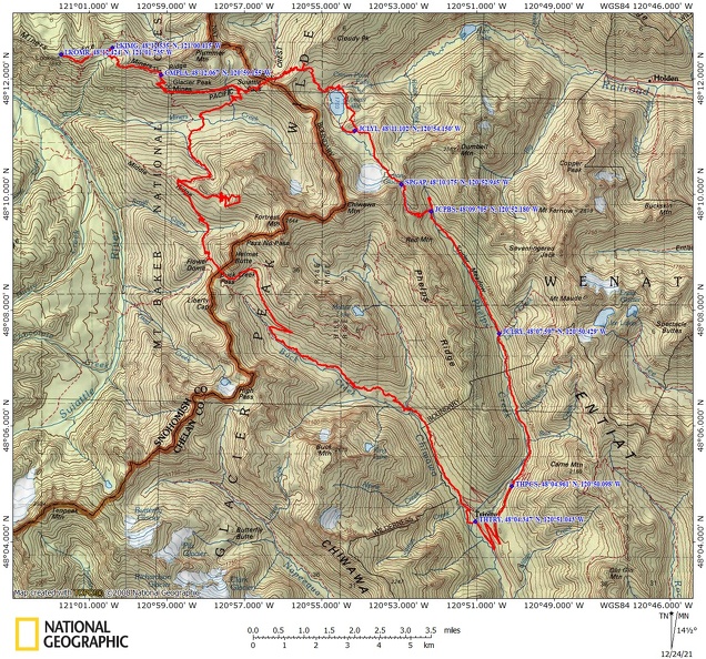
Phelps Creek Trail, Miner’s Ridge Trail #785, Miner’s Ridge Lookout Trail #785.3, PCT #2000, Buck Creek Pass Trail #789, Sheep Camp Trail #787, Buck Creek Trail #1513, with connections to various others.
There is at least one geocache for this trail at: N 48° 04.343 W 120° 50.988 Info at Geocaching.com
Trail Maps:
Topo Map, Download Garmin .gpx file, Open Garmin .gpx file
This trail is also known as Spider Meadows Trail. Once you have arrived at the trailhead, turn around and enjoy the views of the nearby hills and the peaks to the south. The trail starts out on a wide path which was once a mining road. You soon walk over a small creek which is one of many small creeks you will cross, and in .25 mile you come to the Carne Mountain Trail junction. Keep left and stay on the wide trail which continues at a very moderate grade. In 2.5 miles you enter the Glacier Peak Wilderness and just after 3 miles you will pass some campsites.
Pay attention to this section of the trail so you don’t accidentally take the wrong trail. Leroy Creek has washed out the trail and the re-route trail has a couple of faint spots. Just after Leroy Creek is a junction on the right for Trail 1512, Leroy Creek Trail, which goes to Ice Lakes. Drop back down to the main trail and continue up the valley for another couple of miles to Spider Meadow, at 5.4 miles from the trailhead. This glacial valley is filled with flowers in the spring and in the fall, a mix of brown and green. There are several campsites and a pit toilet at this end of the valley and a few at the head of the valley.
Walking through the open valley, admire the views of the mountains beside and ahead of you. It is a gentle ascent through the valley and the trail threads across Phelps Creek a few times at the head of the valley. Climb a little more steeply to the junction to Phelps Basin, 6.7 miles from the trailhead, and drop by for a visit. This pleasant little cirque has a few sloping campsites as the sides of the mountain slopes tail out near the creek.
Return to the junction and head up the trail which soon becomes pretty steep as it climbs along the headwalls of the valley. Though it is less than a mile to what is left of Spider Glacier, it will take some time to ascend the tread which is filled with fist sized and larger rocks. At about 7.5 miles you reach the creek that flows from Spider Glacier and cascades down to Spider Meadow far below. There are some campsites here which must be wildly popular in the summer for their spectacular views. There also is a pit toilet here so you don’t have to try to dig a cathole in the rocky ground.
If the weather is reasonable and the snow is soft enough, you can walk over Spider Gap without microspikes. Be aware that when walking on the snow, there could be big voids below you from the stream or rocks that create melted voids around them. Don’t walk in the middle of the snow field and watch your step so you don’t fall through the snow.
There is a stream that flows from Spider Glacier over the precipice down into Spider Meadows and is a good place to filter water.
Lyman Lake
We found a wonderful campsite at Lyman Lake. Upper line in Lake. I overlooked the lakes and the cirque north of spider gap. There were plenty of mosquitoes in July but the deed kept them away.
Some notes for day one.
Once you climb up to Spider Gap look for a rock path or a path through the rocks on the right.
You need to descend through the gully. At the top looking north you will see a trail that leads along the side of the mountain side. Do not take this trail. You want to descend to the lakes through the gully.
When you have descended about halfway there are user cairns over to the left. Follow them down to the upper Lyman Lakes.
Continue following along the lakes until you get to the last of the lakes. There are some nice campsites here. We had a wonderful campsite overlooking the lake and the cirque.
At the lakes is a user trail that goes to the outlet of the last of the upper Lyman Lakes. Walk a short quarter mile or so and have some nice views of upper and lower Lyman Lake and the outlet cascading down a waterfall to become the stream that feeds the Lyman Lake.
The Lyman Lake systems are glacier fed and the water is not good for filtering. Look for the freshwater little streams that appear and disappear in the flatlands around the lake. There are some nice pools to get water to filter although the pools can be fairly small. No fires are allowed in this area. I think that applies From Spider Meadows all the way through the gap and to Upper Lyman Lakes.
A Scenic tip is to take a short day hike on the trail towards lower Lyman Lake. Crest the ridge to the north of the camp and there’s a great view of Bonanza Peak to the northeast. In the mornings this is in the shade and in the afternoon it is shining in all its splendor.
Descend along Upper Lyman Lake or Lower Lyman Lake and then come to a large log stream crossing over the raging outlet of Lower Lyman Lake. Just after crossing, turn left and head to Cloudy Pass. There are some nice views of the lake and you could swim in it if you dare. At Cloudy Pass look for a boot track going off to the right. Follow that up about a quarter of a mile to great views of glacier Peak. Rest at Cloudy Pass and then drop fairly steeply down to a trail junction and take the hiker shortcut on the left. This hiker shortcut traverses blocky rock from the nearby mountain that you have to sometimes use your hands to negotiate the way.
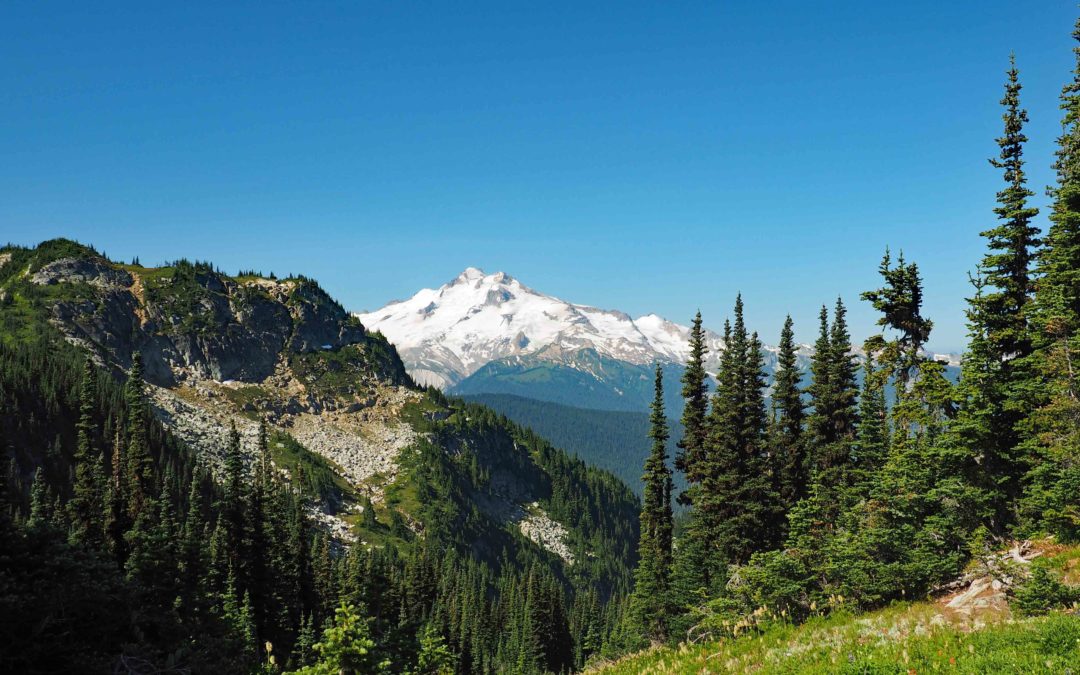
We hiked to Image Lake and took a swim and then got some pictures of Glacier Peak then hiked down over to the Miners Ridge and Lookout. We met Russ and Kelley Dalton who are volunteers restoring the lookout. Russ has been spending the last five summers and he plans to work restoring the lookout through Labor Day. They gave us the tour and told us about how lightning hit a tree just 150 feet from the lookout and Kelley was holding a knife and the lightning bolt affected her nerves in her three fingers which are still numb from the lightning strike. The view from the lookout and along this end of Miners Ridge is simply stunning. You go along the top of the ridgeline and you have amazing views of Glacier Peak and all the mountains surrounding it. Looking to the north you have a mountain range that’s not the high route and deep valleys on either side.
We hit the PCT and then started climbing. Trail is somewhat brushy and ready but not all that to have a reading. Fairly dusty. The trail soon came out along a large avalanche slope and there were several trees across the trail and you could see many broken and dead trees down the hillside. The open slope gives an amazing view of glacier Peak. We walked along for 15 or 20 minutes with a fantastic view of Glacier Peak on our left. We also crossed a large stream cascading down the mountain. It’s a great place to get some water but there is plenty of water on tiny little streams along the way at least in late July. After that we reached the next trail junction to get to Miners Ridge and stopped to put some earbuds and music on so that we could not think about how hard it was to climb steeply for 900 feet up to camp. With our music on it didn’t take long to climb up to Lady Camp. We had found out from Russ and Kelley, who we met on the trail, that Lady camp was named because probably about 100 years ago they allowed sheep to be up here on summer range and a Basque sheepherder carved a figure of a woman into a tree. When we got to camp we met Russ and Kelley again and Russ walked up and showed us the tree carving. It turns out it is right next to where we camped. There’s also the top of the front or the head of a bedframe there propped up against the tree. This camp also has a toilet so we didn’t have to dig any cat holes once again. We don’t have great views from our campsite but it was in the shade which is nice on a warm day. There was some wind to keep the bugs down a little bit but it’s been a pretty buggy trip so far.
I have to rest a bit at our campsite Sean then the three of us went to Image Lake on a day hike. The trail to Image Lake climbs up a bit and then along a wide open mountainside meadow with incredible views of Glacier Peak and then drops down into the basin for Image Lake. We went swimming at Image Lake and then dried ourselves off in the sun. Jeremiah went back to camp and Sean and I continued on to the Miners Ridge and to Miners Ridge Lookout. The Miners Ridge is an incredible ridge that is almost level and splits to deep valleys on one side that has glacier Peak to the south and the other side has views of many more small mountains to the north. We got to the lookout and met Russ coming up the trail. He took us up for a tour inside the lookout which he has been restoring. He is working on the roof this summer and all the materials had to be brought up by mules and pack horses. He’s found some old photos of the original lookout which showed just a shack with the person who staffed the lookout. That person, Andy Holland, has written a book called Switchbacks and you can read about the staffing of this lookout.
Walking around lookout I had Verizon cell service and was able to text my wife about our change of plans. I also was able to send her a picture from the lookout. It has a jaw-dropping glacier Peak and all the mountains all the way around. We could also see a fire or a Pyro cumulus cloud blooming over the mountains from a fire in the Methow Valley. Luckily for us the wind has been from the northwest and we haven’t had any smoke.
A scenic tip for seeing Glacier Peak from Image Lake is on the north side of the lake is a user trail that climbs up above the lake. Be sure to take this short little trail for a classic view of glacier Peak behind image lake. If you can be here for sunrise there can be a lovely glow on the mountain.
At the quarter mile before the junction with the PCT is a big stream where you can splash in to get cooler. Once on the PCT we turned right and started heading downhill towards the crossing of Miners Creek. Continuing down through some lazy switchbacks we passed several small streams and one a really nice viewpoint of Glacier Peak. You also have to cross that big stream again either via a slippery log or slippery rocks.
Once you reach the junction of the PCT and Buck Creek Trail you really start a steep climb up Middle Ridge. Trail switchbacks incline steeply and about a third of the way up with a great place to stop for water. Continue climbing and eventually break out into sundrenched slopes with exceptional views back towards Image Lake and Lady camp. After climbing about 2,000 feet you reach a junction at the top with Middle Ridge. Turn left here and walk a mile to where you camp for the night. There are at least three good camps to choose from on Middle Ridge. This alpine meadow has a knockout view of Glacier Peak. We spent some time in the meadows at camp. We used bug nets and plenty of insect repellent because during the day the blackflies and horseflies are out and in the mornings and evenings the mosquitoes are out in force.
From a small creek you climb steeply up the trail for a mile and a half or so where it flattens out at the junction to Flower Dome. You are not yet at Buck Creek Pass. Continue or take a break here and then continue up into giant alpine meadows. Looking down you can see avalanche run-outs and perhaps even lingering patches of snow. Glacier Peak looms large in the distance.
Start on the Buck Creek Trail at or near Buck Creek Pass. You can see the campground down below you in the saddle. It doesn’t look like there’s any water in the area and the closest water is about a quarter mile down the trail. The trail drops through or drops down along the slopes of a steep rocky mountain. Brush and wildflowers abound in this section and there’s a lot of small creeks to step across too. You get a few more glimpses of glacier Peak and then it’s lost from view for the rest of the trip. As the trail continues to gently drop into the forest the condition of the trail improves greatly. There’s a lot less brush in the trail once you pass the steep side trail on the left which leads to a camp at Helmet Butte.
The trail is also somewhat dusty here in the summertime so you might want to space out hiking along this section.
The trail continues to drop and passes through a burned out area. It switchbacks down through the burn again and goes through some more avalanche zones. You go through some avalanche zones first then the burned area. In the burned out area the trail crews have been through lately cutting the dead trees out of the trail. After that, continue to descend to the Chihuahua River Trail. This trail appears to be an old Forest Road and is much more open and less brushy than the trails you have previously been on. You can hear the sound of Buck Creek in the distance down in the canyon.
Enjoy the photos!!
Gallery Pics
Switchback Steve
Recent Comments