


Vicinity Location: The trailhead is about 26 miles northeast of Portland, Oregon in Clark County.
Directions:
From Portland, OR drive towards Battle Ground to NE Berry Rd. to the intersection of NE Berry Rd. and NE Kaskillah Drive. Just before you get to that intersection look on the left for a very large yellow gate and that is the parking area.
A Discover pass is required to park here.
No bathroom at the trailhead.
Length and Elevation:
Total trip is 6 miles. Elevation at the trailhead is 1,600 feet. Total ascent is 1,000 feet and total descent is 1,000 feet. Highest point is at 2,100 feet. Lowest point is 1,600 feet.
Trails:
DNR Road BG-2000 Road, Bells Mountain Trail, Sword Fern Way
There is at least one geocache for this trail at: N 45° 48.581 W 122° 23.163 Info at Geocaching.com.
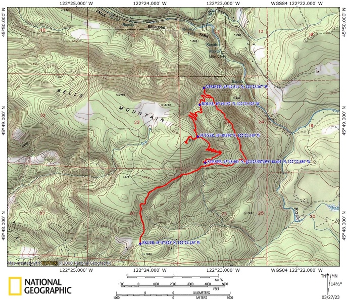
Trail Maps:
Topo Map,
Download Garmin .gpx file,
Open Garmin .gpx file
Review: February 9, 2021, January 27, 2022
From the large yellow gate walk on a gravel logging road for about .6 miles You reach a Junction where you continue right to stay on N. East Berry Rd.
In about a mile father you come to the first crossing of Sword Fern Way.
Turn to the right and go downhill for about a half mile and you will meet Bells Mountain Trail. Turn left here and walk through the forest in clearcuts for about a mile.
In about another mile you come to a logging road that dead ends at the Bells Mountain Trail.
If you want an outstanding view of Mount Saint Helens continue along the Bells Mountain Trail for about another 0.2 mile. Otherwise turn left and go uphill on the unsigned logging road to the next cut-off for Sword Fern Way.
You will cross several small streams on sturdy bridges as you venture through the second growth forest. The undergrowth along the trail is mostly Swordferns, bracken ferns, salmon berries, and salal.
Climb steadily up several switchbacks gaining almost 500 feet up to the High Point on the trail.
At the highest point in the trail there is a junction that leads off to the right. This goes a short distance out to a large clear-cut and a communications tower. From there are some views of Mount Hood from this clearing but over time trees will grow to obscure the view. Back on the main trail you start descending to the logging road. You will go down fairly steeply via several switchbacks.
Once back to the road turn right and walk the 1.5 miles back to the gate.
Neither of these trails have an abundance of wildflowers and both of these trails are snow free throughout most of the year.
Enjoy the photos!!
Gallery Pics
Switchback Steve
Recent Comments