

Vicinity Location: Bureau of Land Management Alsea Falls Recreation Area
Location: The trailhead is 20 miles southwest of Corvallis, OR near the community Alsea.
Directions:
From Corvallis, drive west on OR-34 W, Alsea Hwy for about 23 miles to Alsea. From the town of Alsea drive about .6 of a mile, following signs out of town towards Alsea Falls. Turn left onto Alsea-Deadwood Highway, driving for 1 mile and then turn left onto South Fork Road. Continue on this road 8.3 miles and then make a left into the Alsea Falls Park day use area.
During the Open Season there are bathrooms and water available at faucets in the day use area. for the Alsea Falls there’s a trail that leads off to the right past some bathrooms and some water.
Length and Elevation:
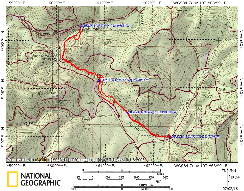
Elevation at the trailhead is 842 feet. Total ascent is 540 feet and total descent is 540 feet. Highest point is at 880 feet. Total trip is 5.7 miles.
There is at least one geocache for this trail at: N 44° 19.656 W 123° 29.783 Info at Geocaching.com.
Trail Maps:
Topo Map, Download Garmin .gpx file
Review:
From the first parking area, enter the forest, walk for about 100 feet past the bathrooms, and take a right at the first Junction then continue past picnic tables and through the wonderfully fragrant forest. The trail crosses small bridge and winds through the forest near the South Fork of the Alsea River. Take the trail to the campground and at the beginning of the campground turn left and cross over the stream on a sturdy metal bridge with a wood deck. Once you get across the street turn right and follow the creek upstream for a bit listening to the pleasant sounds of the stream as you walk along the trail. Soon you cross a boardwalk over a wet area where stinging nettle grows along the trail. After about a mile-and-a-half 1.5 miles you’ll come to a junction for Trail 8. This is the hiker only trail that leads to a forest service road. Continue along the stream heading gently uphill. Sometimes the stream will be within earshot and sometimes you’ll be in a quiet Forest. You’ll pass a lot of Salal growing on the forest floor as well as some patches of Wild Ginger and some Apple Clover. Be sure to have a sample of the Apple Clover as you pass by.
The trail continues through the forest and crosses the stream on a nice bridge and soon after you come to the end of the trail where it meets a Forest Road. Explore the little meadow nearby and then turn around and make your way back towards the campground.
Stay on the same side of the stream and pass by the bridge and campground. In .5 mile you’ll pass the bridge to the day use area. Keeping to the same side of the stream, head uphill toward Green Peak Falls just after the bridge to the day use area. Climb into the woods and you can here Alsea Falls off to your left.
After walking about 500 feet up the hill the trail dips down a little bit and comes to a used trail dropped sharply down to the pool below the waterfall. It is best to skip this steep and difficult user trail because there’s a much easier way on the other side of the stream to get great views of the falls.
Just a little farther down the trail you descend two flights of stairs and there is a maintained trail that switchbacks down to the stream. Take this trail, which has a much gentler grade, and go down for pleasant views. When you come up from the stream, make a left and continue downstream through the forest.
Drop down through the woods and pass a large single camp area on the right. This is in McBee Park and is on land owned by the Hull-Oakes Lumber Company. From here, continue along what is now a level, or slightly uphill dirt road, passing a road on the left that drops down to the stream. An abandoned dirt road branches up the hill on the right. Twenty-five yards after this dirt road, a hiking trail leads up into the woods and to a little clearing which is actually a four-way junction. Turn left and drop back down the the hill a bit. Now the trail descends at a moderate grade down to a couple of trail junctions that bear to the left towards a car camping area. Once you reach the bottom of the grade, turn right and follow the trail across the bottomlands. A few minutes from the Falls you leave the bottomlands and climb very steeply up a little hill to bypass what appears to be a marshy area. There’s a few glimpses of the stream below as you walk through a mix with cedars, some of them are fairly large.
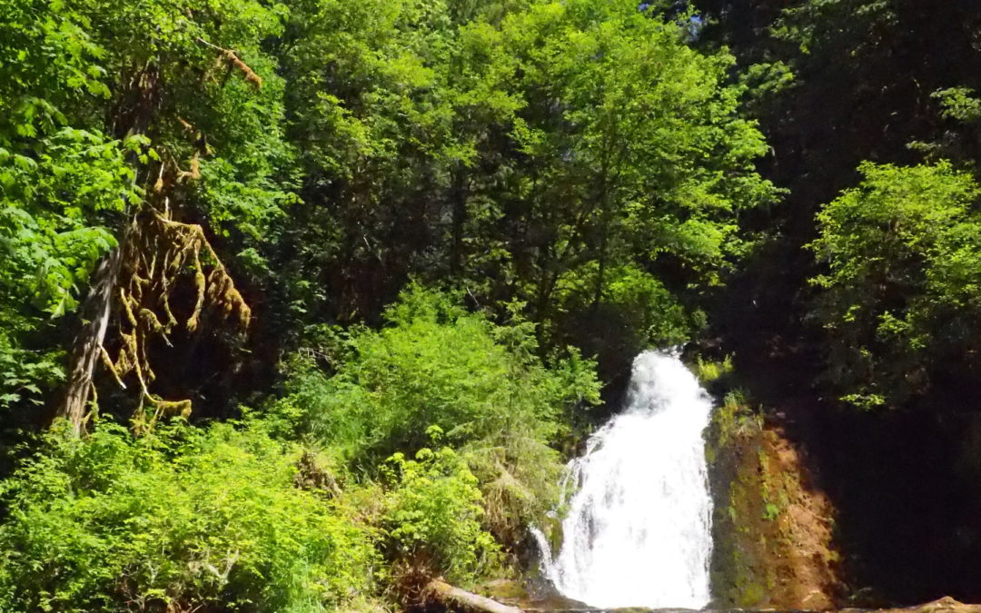
Green Peak Falls is a lovely little waterfall cascading 45 feet down and then over a second small Cascade into a nice pool. Once you’ve enjoyed the falls head back along the way you came back to the sturdy bridge leading to the day use area.
On way back when you don’t forget to turn left to ascend out of the bottomlands and up above camping area.
Once you cross over the bridge turn right and follow the trail that parallels the creek and descends some stone steps. There are a couple of side trails that lead down to the river bank for some nice views of the 30 foot high falls. When the water is low you can walk on the bedrock of the streambed to get very close to the bottom of the falls.
For the final part, walk back up the stone steps, pass the bridge, and continue walking on the trail along the river. Following this route will allow you to bypass the majority of the parking lot and to come out at first set of restrooms at the first junction you turned on when beginning the hike.
This trip is recommended for small children with some hiking experience due to the steep slopes along the trail to Green Peak Falls. Be aware there is poison oak, poison ivy and stinging nettle along portions the trail
Enjoy the photos!!
Gallery Pics
Switchback Steve
Recent Comments