

Vicinity Location:
The trailhead is about 46 miles east of Portland, Oregon in the Mt. Hood National Forest.
Directions:
From Portland drive east on I-84 to Hood River for about 60 miles and take Exit 62. Turn right at the stop sign onto Hwy 30 East, Cascade Ave for 0.2 mile.
Turn right onto Mt Adams Ave. As you drive 3.1 miles, Mt. Adams Drive will turn slightly right and change to Wine Country Ave and then changes again into Country Club Road. The road briefly backtracks next to the freeway then turns south and ends at the T-intersection with Barrett Drive.
At the T-intersection with Barrett Drive, turn left, and follow Barrett Drive for about a mile to Tucker Road. Turn right on Tucker which is also Hwy 281. Follow Hwy 281 as it crosses a bridge over the West Fork of Hood River. This will take you to the abandoned mill site at Dee. Take the fork to the right onto the Lost Lake Highway, and follow signs to Lost Lake for about 8 Miles to well signed Junction where you turn left on Lolo Pass Road.
After 3 miles on Lolo Pass Road turn left on Forest Road 16. It is a paved Road forking off underneath the power lines and heading uphill. Drive 5.4 miles and turn right at the large intersection with Forest Service Road 1650. The pavement ends in about 200 feet and turns into a gravel road. From here drive 3.6 miles to the trailhead at the end of the road. To do this, stay left and uphill on the main road at the next 3 intersections, though you may only see 2 of the intersections.
Trail:
Vista Ridge Trail #626, Timberline Trail #600
Trail Maps:
Topo Map, Download Garmin .gpx file
Length and Elevation:
10.2 miles roundtrip. Elevation at the trailhead is 4,470 feet. Total gain is 3,800 feet and loss is 3,800 feet. Highest elevation is 7,750 feet and the lowest elevation is 3,800 feet.
Review: 11/10/2016
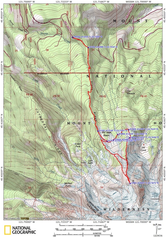
This starts at the Vista Ridge Trailhead. The trail begins at the far end of the parking lot on a rocky trail in a narrow corridor of hemlock trees. The trail opens up a bit as it follows an abandoned Forest Service road. The tread soon improves to be a nice walk on a carpet of hemlock needles and just under 0.5 mile you reach the junction with the Vista Ridge Trail #626 where you turn right to head up the Vista Ridge Trail. This also is an entry point to the Mount Hood Wilderness and there is a wilderness permit to be filled out during the season.
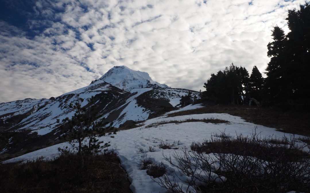
Going up the trail, it doesn’t take long to climb up into the area burned by the Dollar Lake fire of 2011. The fire was started by lightning and burned about 6,300 acres. Continue climbing about a quarter of a mile and the trail levels off for about 0.5 mile then resumes its climb along the ridge. On a clear day you can see Mount Hood through the surrounding silver forest.
Continue to climb through the silver forest for about the next 1.5 miles. You pass from the burned area back to the unburned area but you can see where the forest fire swept up the mountain slopes on your right. At 2.6 miles come to the junction for the Eaton Park Trail which is on the right.
Continue straight ahead ahead and enjoy great views of Mt. Hood. The trail goes along the edge of Vista Ridge and at just under 3 miles you come to the junction with the Timberline Trail #600 where you make a sharp right turn. Walk along the gravelly trail climbing up along the side of the ridge. Just before the trail crosses the spine of the ridge, look for a tiny user trail going off to the left.
Continue to pick your way up along the ridge while looking for the user trail that leads up. You can follow this ridge to the gap between Barrett Spur and Mount Hood. If the eastern snow slope looks too dangerous then cut east to the next ridge.
To do look over where you see the end of the krumholtz on the east Ridge find a good place to cut across the valley, picking your way across the rocky meadow. Once you get across the little valley keep just above the edge of the krumholtz and you’ll find the user trail when you attain the eastern ridge, which seems to be a better beaten track. Follow this up to the gap near Barrett Spur or continue up to the spur. Either way the views are fantastic on a clear day.
You can climb up the rock spine of Barrett Spur but the day of this hike it was too windy.
Heading back, trace your way back down among the rocks, staying on the eastern ridge. Dollar Lake will come into view on the right of the ridge as you’re heading down.
The trail drops down along the ridge and after a while you come to come to a really sketchy place where the krumholtz trees have blocked the ridgeline. You have to drop down below them and then work your way along the dirt slope and regain the ridgeline after passing the trees. It isn’t too much farther before you get to a well-worn track going down along the top of the ridge. Be sure to pause here and turn around for another spectacular view of Mount Hood.
Continue dropping along the ridge and after awhile you’ll see Dollar Lake. Follow the trail as it switchbacks down to the east shore of the tiny lake and enjoy some nice views and perhaps some reflections of Mt. Hood.
Go to the east side of the lake and look for the trail that continues downhill and joins the Timberline Trail. Turn left at the Timberline Trail and work your way back to the Vista Ridge Trail. The trail has some ups and downs as it crosses through little creek beds, the first ones being seasonal creeks and then crossing several that flow all year long.
Since you’ve hiked the whole loop and been above the sources of these creeks, you know these streams come from springs and should be safe to drink from to provide all the water you want if you are running low.
At the junction of the Vista Ridge Trail turn right and head down the trail back to the trailhead, remembering to turn left as you leave the wilderness.
This trail is good for children who are experienced hikers but be sure cut over to the eastern ridge to avoid the long, steep snow slopes. Also, wear something orange in the fall hunting season as hunters use this area.
Enjoy the photos!!
Gallery Pics
Switchback Steve
Recent Comments