

Notice: 9/1/2023 – Although open, this trailhead is in an area impacted by the Beachie Creek and & Lionshead Fires. Before visiting areas affected by wildfire, make sure to review the 4 Steps for Safety for recreating in burned areas.
Vicinity Location:
The trailhead is about 55 miles southeast of Portland, Oregon in the Bull of the Woods Wilderness and Willamette National Forest.
Directions:
From Portland, take I-5 south for about 46 miles, driving through Salem.
Take exit 253 for OR-22 E toward Detroit Lake/Bend and drive 0.3 mile to the traffic light, choosing one of the left lanes.
Turn left onto OR-22 E/Mission St SE, crossing over I-5 and continue to follow OR-22 E for 49.4 miles.
At Detroit turn left onto FR-46 for Breitenbush, Elk Lake, and Olallie Lake.
Drive 4.3 miles and make a left onto paved FR 4696.
Drive 0.8 miles and turn left onto gravel FR-4697, signed as HIGH CLEARANCE ONLY.
Drive the winding, potholed, and washboard road for 4.6 miles to a Y-junction and turn left. Your top speed on this section of road will be about 15 mph.
Drive another 2.4 miles to the junction for the Elk Lake Campground. You can park here or turn left onto FR 390 and drive down to the lake.
The trailhead is near the popular Elk Lake so parking can be very difficult on busy weekends.
No permits are required to park along the road or in the day use area.
There are bathrooms at the parking lot by the lake.
Elk Lake is a great swimming lake.
Length and Elevation:
7 miles roundtrip. Elevation at the lake parking is 3,760 ft. Highest Point on the trail is 5,482 ft. There is 1,950 ft elevation gain and 1,950 feet elevation loss roundtrip.
Trails:
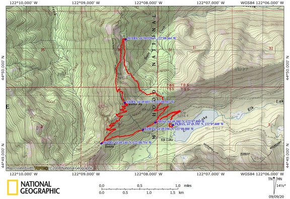
Bagby Trail #544, Battle Ax Mountain Trail #3340 with connections to various trails.
There is at least one geocache for this trail at: N 44° 49.401 W 122° 07.429 Info at Geocaching.com.
Trail Maps:
Topo Map, Download Garmin .gpx file, Open Garmin .gpx file
Review: August 2, 2020
Find the Bagby Trailhead, Trail #544 and head up the trail. The trail levels at a pond with lily pads and yellow water lily flowers. Continue upwards and pass through a large salmonberry thicket and cross a series of springs. Soon you’ll cross a talus slope where pikas sound the alarm. At about 2.7 mies you come to a trail junction with a primitive campsite to the right. Turn left and go uphill on the Battle Ax Mountain Trail #3340.
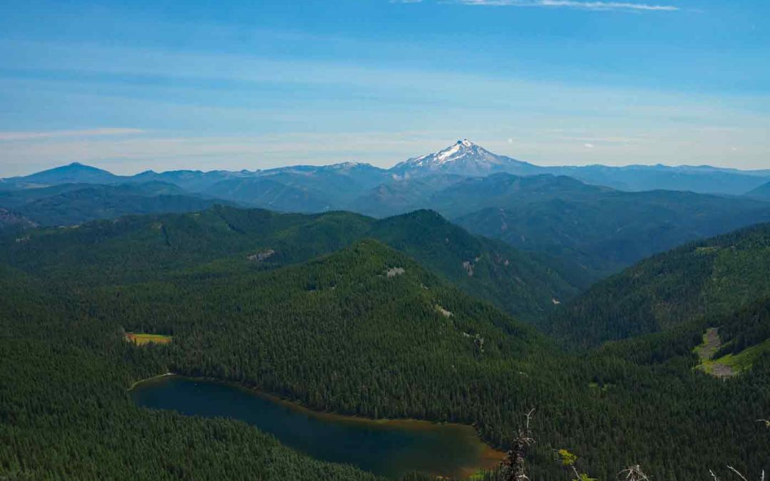
The climb brings you out of the trees and provides views all the way to the Washington Cascades. Once on the summit ridge hike to the old lookout site where a few concrete pillars mark the site of the old lookout. A short trail continues down a ridge of platy andesite to great views of Elk Lake and Mt. Jefferson.
Back at the summit is the trail to descent. Just past the summit turn right to switchback down the other side of Battle Ax Mountain. Go down the shattered slope of stones. Sometimes it sounds like you are walking on shards of glass. Several switchbacks lead down into the forested slopes above Elk Lake.
The brushy trail passes below rock cliffs then continues to drop down to Beachy Saddle where there is a trail junction. Turn left and follow the old forest road along the gullied road through the forest.
Walk by a dripping spring with maidenhair fern on the left and continue to walk down the gullied road. The road crosses a “tank trap” then comes to a small turnaround where some people park. Walk down the road back to the trailhead for Battle Ax Mountain then to your vehicle.
After the hike the lake is a great place for a swim. Elk Lake has a shallow shoreline and gets relatively warm for a mountain lake. The boat launch area has a nice gravelly bottom. Other areas have some mud on the bottom.
Enjoy the photos!!
Gallery Pics
Switchback Steve
Recent Comments