

Directions:
From Portland, OR, take I-205 north to exit 30b to Battle Ground. Move over to the middle or left lane and proceed north on SR503 for about 10 miles to Battle Ground. Continue north on SR503 about 5 1/2 miles further and turn right on Rock Creek Road. Follow Rock Creek Road for about 8 1/2 miles to Moulton Falls County Park. You can park in the first lot or there is an overflow lot on the right about ¼ mile past the first parking lot which is closed during the winter.
No parking permits are needed.
Flush toilets are available at Moulton Falls County Park.
Length and Elevation:
10.4 miles one-way with connector trails. 7 Miles each way for Bells Mountain Trail. Moulton Falls connector trail is .7 miles, Rock Creek Campground connector is 1.9 miles. Elevation gain 1,650 Feet and loss 1,300 feet to the turn-around point. Total gain and loss is 2,950 Feet. Elevation at the trailhead is 600 feet, the summit elevation is 1,465 feet.
Trail:
Moulten Falls Trail, Bells Mountain Trail, Tarbell Trail.
There is at least one geocache along this trail at: N 45° 49.941 W 122° 23.273 Info at Geocaching.com
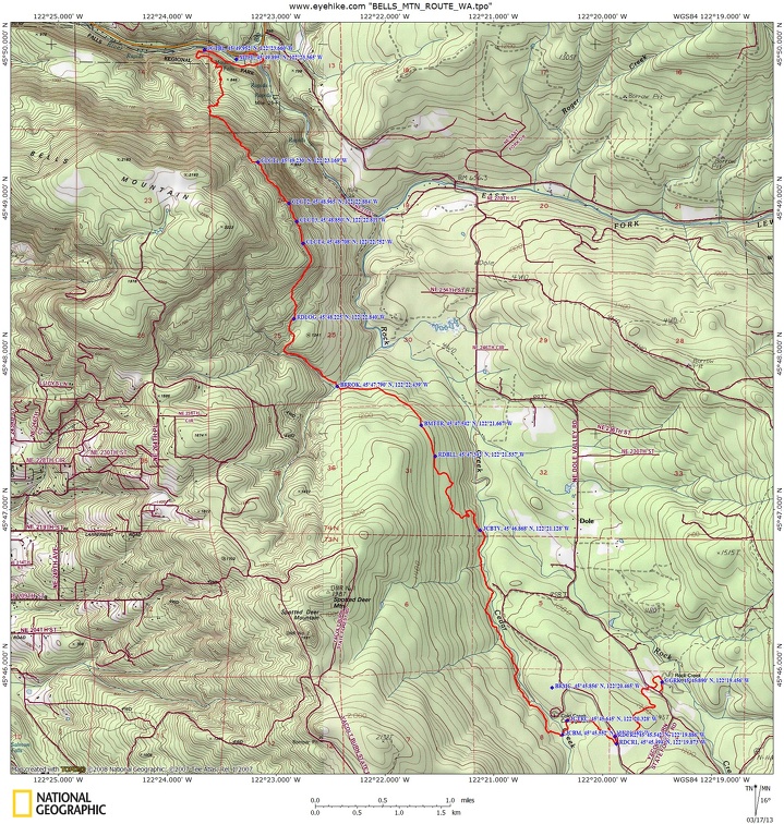
Trail Map:
Topo Map, Vancouver Parks Bells Mountain .pdf, Download Garmin .gpx file
Review: June 11, 2005, March 17, 2012
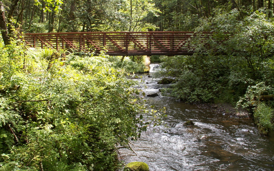
Walk along the East Fork of the Lewis River and cross the high arch bridge over the river. Proceed down the trail about ½ mile to the Bells Mountain trailhead. The trail ascends steeply for the first 1.75 miles and crosses four small streams. After the first clear-cut, the trail rolls up and down with very few level stretches. This trail passes through Department of Natural Resources land and there are several recent clear-cut areas. Most of the clear-cut areas have narrow buffer areas of trees on both sides of the trail. Sections of the trail have clay soil, which makes the trail slippery in the steep portions when the weather is wet. The trail passes through the forest and crosses many more streams on small bridges.
About 3.5 miles from the trailhead is a dirt road crossing the trail. The trail continues just to the right on the other side of the road and continues to the southwest, bearing to the right.
There is a large concrete decked steel bridge, which crosses a tributary of Rock Creek at about 4 miles. About 200 feet past the 4.5 mile trail marker, the trail comes to a gravel logging road marked RDBLL on the map. Walk to the right up the logging road for about 50 feet, and look for trail dropping off to the left.
The trail generally loses elevation for about .5 mile, then enters another clear-cut. The descent steepens and drops down a pair of switchbacks to a 4-way junction marked JCBTV on the map. Coming from Moulton Falls, it is easy to see the trail continues straight ahead. Coming from Cold Creek Campground, the continuation of Bells Mountain Trail is not so apparent. Coming from Cold Creek, the continuation of the trail is straight ahead and uphill.
Walking a short distance brings you to another short section of trail that is used by ATVs. Follow along for about 100 feet and look for the Bells Mountain trail on the left. The trail follows along the creek, passing by a creek ford.
The rest of the trail has bridges and culverts and is easy to follow. There is some horse traffic as you get close to Cold Creek Campground. At 6 miles from the Moulton Falls parking lot, the trail drops down to Cedar Creek, then climbs above the creek, then slowly drops back down and crosses over Cedar Creek on the second steel and concrete decked bridge. On east side of Cedar Creek is a trail junction to Cold Creek Campground, to the left and along the creek. To the right, near the creek, is a short walk to a wheelchair accessible overlook of Cedar Creek Falls.
From the bridge, the Bells Mountain Trail continues to the right and up the hill. In .1 mile is a junction back to Cold Creek Campground. Continue to the right and in .5 mile is another trail junction and the end of Bells Mountain Trail. You are now at a junction with Tarbell Trail, which is a 23 mile loop trail. Silver Star Mountain, Larch Mountain, and Kloochman Ridge Trails are to the right. Rock Creek Campground and Tarbell Picnic Area are to the left.
Take the left trail and continue to a gravel road that goes to Cold Creek Campground. Turn left on the road and follow it for about 100 yards. Look for the trail sign on a tree and turn right, back onto the trail. This trail leads to Rock Creek Campground. This last 1.5 miles of trail is heavily used by horses, but you can skirt around the muddy parts. In about 1.4 miles, the trail crosses Dole Valley Road and continues to Rock Creek Campground and horse camp.
The Bells Mountain Trail was built and is maintained by the Chinook Trail Association. The amount of work and dedication this small group put into building this trail is truly amazing. You should consider hiking this as a shuttle trip or continuing on towards Silver Star Mountain on the Tarbell Trail as an overnight trip. Note: If you make this a shuttle hike a Washington Discovery parking permit is required at the Rock Creek Campground and Cold Creek Campground as of July 1, 2011.
Enjoy the photos!
Gallery Pics
Switchback Steve
Recent Comments