


Notice: 7/12/2024 – This area is closed except for the brief time each summer when the Yakama Nation opens the area to hikers. Day use parking cost is $20 for up to 6 people between July 29th and September 9th, 2024. The open period can vary each year by a couple of weeks.
Vicinity Location:
100 miles east of Portland on the Yakama Indian Reservation.
Directions:
From Portland, OR, take I-84 east to exit 64 at Hood River. Cross the toll bridge across the Columbia River and turn right at the “T” with Highway 14. Drive east for about 2 miles and turn left onto Highway 141, and follow the signs to Trout Lake.
To reach the Ranger Station, stay on Highway 141 out of Trout Lake. The Mt. Adams Ranger Station is on Highway 141, on the left, .8 miles past the junction of Mt. Adams Rec Hwy and Highway 141.
To reach the trailhead, go straight at the intersection of Highway 141 and Mt. Adams Rec Hwy, Road 82. At 1.1 miles, stay right at the road junction. You’ll see a sign for Bird Creek Meadows. At 1.4 miles, stay right again at another road junction. At 4.4 miles, you enter the Gifford Pinchot National Forest. Follow the signs to Bird Creek Meadows. The pavement ends 4.5 miles from the junction of Hwy 141 and Mt. Adams Rec Hwy.
Continue on the main road, following the signs to Bird Creek Meadows and Road 82. Six miles after the pavement ends, turn onto Forest road 8290. About .6 miles farther, you go straight at a junction with a logging road. The road becomes dusty, narrow, and rough.
At 13.2 miles, you cross over Bird Creek. After four slow miles farther, you come to Mirror Lake. You’ll need to purchase your day use or camping permit here.
Continue straight ahead to a large intersection. A sign indicates that Bird Creek Meadows is straight ahead. Follow the road another mile to the fee box and a small parking area at Bird Lake. Drive time is almost 75 minutes from White Salmon.
Parking fees are $20 per day or $30 for each 24 hour period. You’ll need the correct amount to self-register.
For information on parking and camping, call the Yakama Nation Forestry Development Program, (509) 865-5121, ext 657
No bathrooms available at the trailhead or along the trail.
Length and Elevation:
8.5 Miles roundtrip. Elevation gain 2,078 Feet and loss 20 feet to Iceberg Lake. Elevation at the trailhead is 5,594 feet, the high-point elevation is 7,652 feet. Total gain is 2,176 feet and loss is 2,176 feet.
Trails:
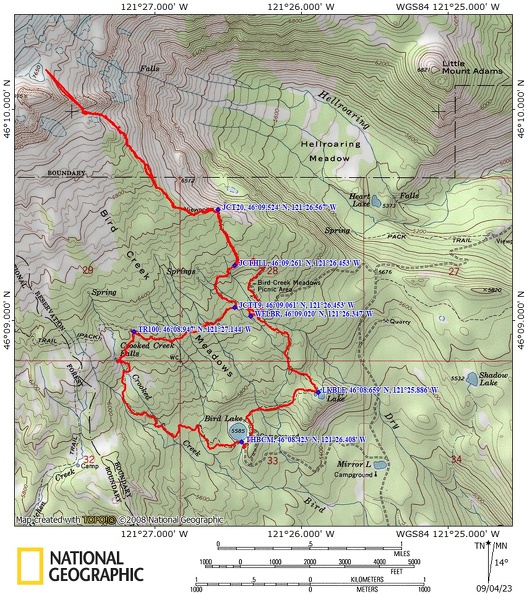
Bluff Lake Trail #105, Round The Mountain Trail #9, Trail of Flowers #106, Hellroaring Viewpoint Trail #67, Sunrise Camp Trail #20, Bird Lake Trail #100.
Link to vicinity information, including fire updates.
Trail Maps:
Topo Map, Download Garmin .gpx file, Open Garmin .gpx file

History:
Mt. Adams is a stratovolcano composed of several cones that from volcanic flows occurring over several periods of time. It is the second highest mountain in the Pacific Northwest. The summit is 12,281 ft tall. The oldest lava found at Mt. Adams is about 450,000 years old. 12,000 to 25,000 years ago was when the majority of Mt. Adams was formed. About this same time, ice covered almost the entire Wilderness area. Glaciers extended far down many of the surrounding valleys. The glaciers smoothed and streamlined formerly rough lava surfaces.
The road to Cold Springs is on top of a lateral glacial moraine. About 5,100 years ago, the Pinnacle was formed by a giant avalanche. The summit rocks broke down over time by acidic gasses from the volcano. Debris from the avalanche swept down the White Salmon River to the Trout Lake Valley. You can still see yellowish boulders around the valley today. 3,000 to 6,000 years ago, lava created the Muddy Fork and Aiken Lava Flows. In 1921 and 1983, large avalanches broke off and swept down Mt. Adams. There was once a mining claim on the summit area of Mt. Adams for sulfur but it never was commercially feasible and was abandoned in 1959.
Lightning started the Cougar Creek Fire on August 10, 2015 and it burned about 8,800 acres in the area. Some areas burned trees and all the organic matter on the forest floor, other areas were lightly burned, and the fire skipped over other areas. About half of this trail was burned in the fire.
Review: July 17, 2005, September 3, 2022
This trail is on the Yakima Indian Reservation and is closed to the public in the off-season. Contact the Mt. Adams Ranger Station in Trout Lake.
2455 Hwy 141 Trout Lake, WA. 98650.
Phone: (509) 395-3400 or (509) 395-3420 (24 hr recording for Ranger Station hours).
In mid to late-July, the wildflowers are at their peak. A sunny day allows great views of Mt. Adams and Mt. Hood. Even the top of Mt. Jefferson can be seen on the left shoulder of Mt. Hood. At the time of this review the trails were logged out and all the bridges were in place.
From the permit box, walk back on the road a short distance, turn left at the road junction, and follow the road counterclockwise above Bird Lake to the Bluff Lake Trail 105 . Walk-through the silver forest, crossing a small creek. Continue gently uphill through the burned out Forest to Bluff Lake.
At Bluff Lake there is a Trail Junction. Turn left here and walk away from Bluff Lake. The fire in this section of the forest didn’t kill all the trees so there are some green trees among the burned out snags.
The trail turns northwest and climbs uphill. One old guidebook showed a trail that heads east from Bluff Lake. This is a dead-end trail and if you take it you will have to bushwhack to the road or retrace your path. The story as told to me, is years ago two trail crews started towards each other. One crew started from Bluff Lake and the other from the parking area. They worked towards the middle but the crews never met. They eventually gave up and never completed the trail.
As you continue uphill you will see another small waterfall and the trail follows a small creek. Reaching Bird Meadows, turn right on Trail 9. There is an incredible wildflower meadow with a view of Mt. Adams in the background.
In a short distance, you’ll pass through what is left of the Bird Creek Meadows Picnic Area.
Make a hard left at the Bird Creek Meadows picnic area and gently climb for a bit. If you start descending rapidly from the Bird Creek Meadows Picnic Area then you have missed the trail junction.
Continue on the Trail of Flowers #106 which climbs up a bit then levels off and comes to the Junction for the Hellroaring Viewpoint Trail #67. Turn right here and Hike uphill past a seep and a small stream. There are great views of Hellroaring Canyon, mountains, and wildflowers.
From here continue up in Ridge to Iceberg Lake. The Trail is faint in places, so some route finding will be needed.
As you climb higher, the trail becomes easier to follow. There is a section where it goes, straight up the mountain side for a few hundred feet and then comes out to a small plateau with a snow field nearby.
Climb again pretty much straight up the mountainside to Iceberg Lake. (Note: The last ¼ mile of the GPS to Iceberg Lake is estimated because bad weather turned us back and we didn’t make it to Iceberg Lake)
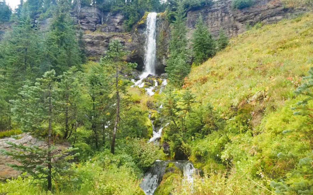
Return back down to the Trail of Flowers junction and turn right onto the Round The Mountain Trail again.for about 1 mile to the junction of Trail 100. Follow Bird Lake Trail 100 about 0.2 mile down to Crooked Creek Falls. Crooked Creek Falls is a picturesque 50 foot tall waterfall that shoots off a cliff, then tumbles down the rocks and forms the creek.
Continue down the trail for about 1.1 miles through the burned out forests, crossing a small creek back to the parking area.
This trail is a “must” hike in July for the spectacular wildflowers, multiple mountain streams, vistas, and waterfalls. You can filter water from the lakes and streams.
Enjoy the photos!!
Gallery Pics
Switchback Steve
Recent Comments