

Note: The road doesn’t open until late May or early June. You have to call Deschutes National Forest in Bend at (541) 383-5300 for the road status.
Vicinity Location:
The trailhead is about 105 miles southeast of Portland, Oregon in the Deschutes National Forest.
Directions:
From Portland, drive about 2.5 hours to Sisters, Oregon using either I-5 or Hwy 97. Once there, turn right on Elm Street and head out of town. Elm Street turns into Forest Road 16. Follow this paved road for 14.9 miles. The pavement will end 13 miles from Sisters. Stay on Forest Road 16 to the trailhead. There is a small parking lot on the right near Three Creek Lake and you can park on either side of the road near the trailhead.
A wilderness permit is required. The free self-registration for a wilderness permit is at the trailhead.
There are no bathrooms at the trailhead. I think there are bathrooms at Three Creek Lake Campground.
Note: Dogs need to be on-leash in Three Sisters Wilderness on Green Lakes, Moraine Lakes, South Sister, Soda Creek, Todd Lake and Crater Ditch Trails, from July 15 to September 15. Cross country hiking is prohibited in wilderness sections of the burn around Park Meadow. No fires within 100’ of water or system trail. Camping and/or campfire restrictions apply at Green Lakes, Matthieu and Golden Lakes, and Moraine Lakes.
Length and Elevation:
Total distance is 24.8 miles. Trailhead elevation is 6,545 feet. Highest point is 8,030 feet. Lowest point is 6,000 feet.
Total elevation change is 6,900 feet up and 6,900 feet down.
|
Broken Top Loop |
||||
|
Itinerary |
Mileage |
Camp elevation |
Ascent |
Descent |
|
Day 1 – Tom McArthur – Below No Name Lake |
7.5 |
7,310 feet |
3,300 |
2,628 |
|
Day 2 – Below No Name Lake – Golden Lake |
8.8 |
6,580 feet |
2,808 |
3,494 |
|
Day 3 – Golden Lake – Tam McArthur Trailhead |
8.5 |
6,545 feet |
785 |
962 |
|
Totals: |
24.8 miles |
|
6,893 |
7,084 |
Trail:
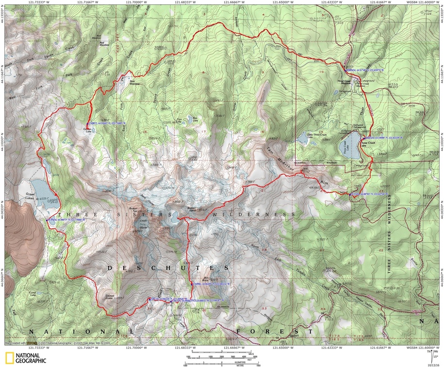
Tam McArthur Rim Trail #4078, Broken Top Trail #10, Green Lake Trail #17, Green Lakes Trail #4070, Park Meadow Trail #4075 with connections to several other trails.
There is at least one geocache along this trail at: N 44° 06.106 W 121° 37.338. Info at Geocaching.com
Trail Maps:
Topo Map, Download Garmin .gpx file
Review: October 8, 2016
It is a very scenic drive to Sisters and then from Sisters to the Tam McArthur Trailhead. From the trailhead it is a moderate climb up the sandy trail strewn with volcanic rocks. The trees are thin here and get more sparse as you climb. You soon get great views of Broken Top, Broken Hand and the profile of Tam McArthur rim.
Walking over to the eastern rim you can look down and see Three Creek Lake, Little Three Creek Lake, and views towards Sisters and Bend. After about 2.6 miles the official trail ends. There is a nice viewpoint on the right overlooking tall cliffs. Walk west and north to continue along the rim until the trail narrows and you’re picking your way among the rocks along the rim, then look to the left for a break in the trees. Drop down about 100 feet on a fairly steep slope with loose soil and find a user trail that traverses north towards No Name Lake.
We kept to pretty much the same elevation and after about 1.3 miles came to the stream that comes from No Name Lake. We continued to follow user trails and crossed a snow bridge over the outlet stream. There will be years when the snow bridge is not a safe crossing so exercise care not to fall through to the stream.
No Name Lake is now a very popular destination from the Todd Lake Trailhead and there could be dozens of people roaming around on a nice afternoon. Even with snow on the ground we saw at least a dozen people.
At the lake there is a path worn most of the way around the lake shore. I walked along the eastern shore to get more views of Broken Top while Matt took photos around the outlet stream. It looks like you could camp on the eastern edge of the lake. The clouds made interesting patterns catching on Broken Top and it can get very windy in the area.
We followed the user trail down towards Ball Butte and the Todd Lake Trailhead. Down in the trees we found good tentsites with nice views of Broken Top. I had to kick some snow away but the wet snow moved easily. It didn’t take long to get our tents set up so we could crack Matt’s crowler. Matt’s footwear was totally soaked from hiking through the snow so he tried to dry his shoes and socks out as best he could. He said he was borrowing his wife’s sleeping bag so he didn’t dare put his wet and somewhat dirty socks in her bag overnight to dry.
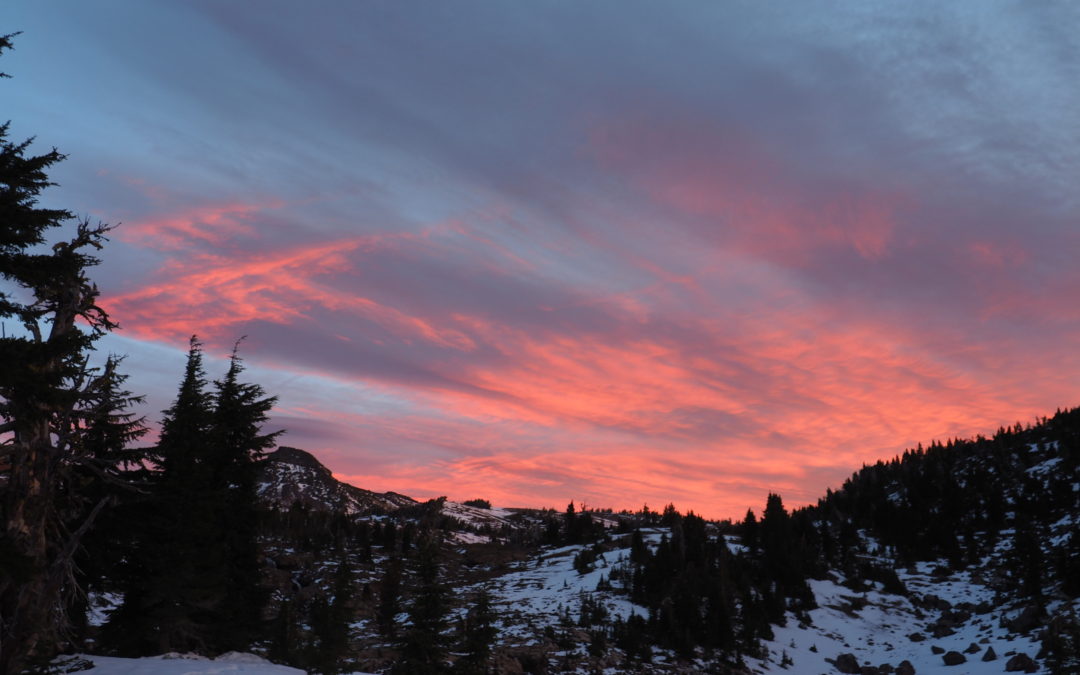
We had dinner and watched as Broken Top disappeared into an ever dropping cloud ceiling. It wasn’t long before we too were enveloped and we said good night. The next morning Matt saw the clouds had gone but they were back for a beautiful sunrise.
I was surprised the temperature hadn’t dropped below freezing during the night, but I had put my water and filter in my tent just in case. It was still pretty early when we saw the woman from the night before coming back down with her lawn chair. It was pretty windy during the night so she probably had it along just for her Instagram picture. Matt said a lot of people trek up there to pose for an Instagram picture.
We weren’t in a hurry so we wandered around the nearby stream for more photo opportunities. Matt got a lot more photos with his beers. We saw one more tent pitched at one of the few campsites in the area. There might be more areas in the flat gravel area that was above us but it looked really wet after the rain and snow.
We headed down to join the Broken Top Trail. There were no signs but the trail comes to the stream from No Name Lake. One trail crosses the creek and goes to the Todd Lake Trailhead but to continue the trip, look for the trail that forks off to the right. The trail soon leads out of the trees and across a flat plain. In about .4 mile you leave the wilderness for a bit and cross Crater Creek Ditch, a manmade canal.
From here the elevation changes are gentle and there are open views to see the Sparks Lake area to the south, and of course Broken Top and South Sister. We soon reached Cayuse Springs where there is also camping and water.
We continued past Cayuse Crater and Matt admired the open volcanic slopes for their skiing opportunities. About 2.9 miles from starting on the Broken Top Trail we turned right at the Green Lake junction and found a nice lunch spot along Green Lake. We had a leisurely lunch on the shore and dried our socks and shoes in the sun while we admired the views of South and Middle Sister.
Follow Green Lakes Trail for about 2.2 miles up to Green Lakes Pass at 7,000 feet in elevation. There are some great view here from the pass and we spent some time admiring the views. Drop down back into the forest and in about .9 mile look for a trail off to the right that slopes up and into the open forest. We walked uphill about .6 mile before dropping down slightly down to Golden Lake. There are many campsites in the trees around the lake and there is a trail on the east side of the like that goes up into the forest to a couple of campsites.
It was really windy at Golden Lake and it took me a long time to set up my tent in the gusty wind. It may be pretty common for windy conditions here because it was really windy the last time I camped here. Matt brought a mountaineering tent along so he set pretty easily in the wind.
We spent the evening looking at the clouds being torn off the Sisters from the wind and there were fantastic lenticular clouds off to the west. We talked about waiting out the rain for a while in our tents and hoped the wind wouldn’t keep us awake all night. During the night I could feel my tent pressing against my sleeping bag first on one side then the next then came the rain.
Happily the rain wasn’t really heavy or steady so we took our time getting ready to leave. The wind continued and I had to be careful not to let anything be blown away. We got back to the main trail quickly and soon passed into Park Meadow. There are a couple of beautiful streams near the junction of the Park Meadow Trail. Follow the Park Meadow Trail #4075 as it heads northeast into the burned by the Pole Creek fire of September 2012.
We followed the trail through the burned area to a 4-way junction. We decided to take the easier route and go straight, on Trail 99 and follow the road the rest of the way back to the trailhead. I think a better choice is to turn right, staying on Trail #4075 and continue through the burn back to the trailhead.
After reaching the car Matt and I drove into Bend for lunch at Trusty Brewing and stopped at Boneyard for some crowlers.
Enjoy the photos
Link to Photos
Switchback Steve
Recent Comments