

Note: The entire lower section of the trail is closed from February 1st through July 15th every year to protect sensitive Peregrine Falcon habitat. The closure is 1/2 mile south of WA Highway 14 to Cape Horn Rd. Failure to respect the closure can result in a $100 fine, and future use of the trail is dependent on hikers respecting this closure.
Directions:
From Portland, take I-205 north past the airport and cross the Columbia River. Get into the right hand lane and take the exit for Camas. Drive about 20 miles and park at the intersection of Salmon Falls road and Highway 14.
There is also parking at an alternate trailhead on Strunk Road. Directions to this location has not been provided in this review.
There are bathrooms at the park and ride trailhead.
Length and Elevation:
7.5 miles roundtrip. Elevation gain 1,500 and loss 1,500, total 3,000 feet in elevation change. Elevation at the trailhead is 490 feet.
Trail:
Cape Horn Trail
There is at least one geocache along this trail at: N 45° 34.305 W 122° 11.875. Info at Geocaching.com
Trail Maps:Topo Map, Hiking Upward, Download Garmin .gpx file
Review: June 16, 2007, October 9, 2010, October 1, 2011, January 26, 2019
This is a great low-elevation hike in the Gorge. Late May through the end of June have the best wildflower displays. In the late spring and summer the seasonal plants and leaves infringe on the trail. Depending on trail maintenance, you will want rain pants for this first part of the trail if there is any chance of rain or early morning hiking. Be sure your hiking shoes or boots have good traction because the first mile or so of the trail above the highway and about 1.5 miles of the trail below the highway is slippery when wet.
The trail passes a huge old growth Douglas Fir, then drops down and crosses a tiny stream and a bridge. From there the trail climbs several switchbacks as it ascends up towards Pioneer Peak.
About 1 mile is a junction with just a trail marker. The junction goes a short distance and leads to a powerline service road. The trail continues straight at the junction. Another junction leading to the powerline road is passed at 1.4 miles from the trailhead.
In the spring there is Columbine, larkspur, and thimbleberry along the trail underneath the forest canopy. In late spring the cow parsnips bloom along with the tiger lillies.
Another junction is reached 1.5 miles from the trailhead. The right junction is the preferred trail and is a gentler grade than the trail that leads straight ahead, which is steeper and rockier.
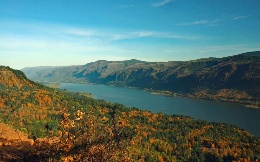
The trail continues up gentle switchbacks and leads another junction for the horse route. Turn left here and walk about 300 feet, passing a couple of side trails, to a commanding view of the Gorge. You can see Multnomah Falls, Beacon Rock, cows grazing in the fields, and boats going up and down the river. Return to the junction and walk slightly uphill for a few hundred feet and then downhill for a few hundred feet to another junction (JCCH5). Take a left and walk a couple hundred feet to another great view of the gorge. Return to the junction and follow the trail downhill. Look down and you will see piggyback plants and Apple Clover or Wood Sorrel. Both of these plants like the damp ground in this area. The Apple Clover is a type of Oxalis and has a sour taste and provides a tasty treat when eaten, though it upsets some people’s stomachs.
The trail descends a few switchbacks and comes out in the woods on a 4-wheel drive road. Make a left and follow the road into the woods for less than 1/10 of a mile and make a left on an ATV trail. This is the first left you can make after joining the 4-wheel drive road. The trail comes out on Strunk Road, which is paved.
Directly across the road there should be a signpost pointing to the trail. Turn left and walk on a path along the edge of a field to a gravel road. Turn right and follow the gravel road .2 mile to the far end of a pasture. At the edge of the pasture is a small gravel path leading off to the left and follow this path into the open woods to the Nancy Russell overlook, passing the continuation of the Cape Horn Trail. Walk down to the Nancy Russell overlook, named in honor of the woman who founded the Friends of the Columbia Gorge. You can enjoy the view because the group purchased this property along the rim of the Gorge and stopped it from being developed into a subdivision. The group restored the land and then sold the property to the Forest Service.
Walk back a couple hundred feet and turn left back into the woods. In about .1 mile is another junction leading uphill. That is the old trail and leads to a pasture. Continue downhill and after descending about .2 mile on some switchbacks, you will enter a clearing that has nice views of the Gorge. The trees have been cut at the clearing because it is the beginning of the fencing that protects the highway and cars below from rocks falling off the cliffs. You can’t see Highway 14 because it is so close to the cliff. You will see some of the retention cables as you walk down the trail.
There is another trail junction here. The trail to the right leads away from the cliffs, through the woods. The trail to the left goes out and along the edge of the cliffs.
The trail then switchbacks down towards highway 14. Just a short time before you get to Highway 14, you pass a building that looks like an outhouse. Perhaps there was a homestead near here. The trail crosses under Highway 14 and continues downhill towards the Columbia River.
Do not walk back to the trailhead along Highway 14 when the lower section of the trail is closed. The road has no shoulders and steep cliffs in places.
This next section is a wet area and take care not to touch any stinging nettle growing along the trail. Cross a small stream, climb a bit up the other side, and continue through the woods. The trail soon comes to a 4-way junction. The right trail leads to parking on SR14 and the left trail leads to a view of a waterfall and an overlook of the gorge. It is interesting to note this overlook is less than 100 horizontal feet from the lower trail, but over 1 mile farther along the trail. The stream to the left forms the waterfall that the trail later crosses in front of.
From the junction, the trail continues to descend and crosses another small stream on a sturdy bridge built by the Washington Trail Association. The trail now drops down a number of switchbacks and descends towards the Columbia River. About .4 mile from the junction is where the trail is closed from February 1st to July 15th for falcon nesting.
Continue down through a forest of oaks and maples as you drop down to a place below scree slopes where the trail levels out. Soon climb several switchbacks across the broken basalt and you will hear a waterfall. Pretty soon you’ll see it come into view. Cross on the large log bridge which provides great views the waterfall. The trail traverses the slopes above the river and descends a short, very steep section and drops down to a paved road. The last few hundred feet to the paved road have large boulders in the trail. Once on the paved road stop and take a look around and above you. You can see SR 14 going around Cape Horn high above you. From here, follow the road uphill about 1.25 miles back to your car, using the pedestrian tunnel for crossing under Highway 14.
Please respect the request not to park, pick up, or drop off hikers where the trail meets the paved road so that the property owner doesn’t shut down access to this trail.
Please keep your dogs on leash because of the two crossings underneath the highway and the many sheer cliffs next to this trail.
Enjoy the photos!!
Gallery Pics
WTA Trail Work
Switchback Steve

Recent Comments