

Vicinity Location:
The trailhead is about 70 miles southeast of Portland, Oregon in the Willamette National Forest.
Directions:
From Portland, drive about 45 miles on I-5 south to Salem. Take exit 253 for OR-22 East towards Detroit Lake/Bend.
Drive about 69 miles on OR-22 East through Marion Forks and drive about 2.7 past Marion Forks Fish Hatchery and turn right on Straight Creek Road. This is just past milepost 69. Straight Creek Road turns into Forest Road 11.
After about 4.3 miles on Straight Creek Road/FR 11, turn right onto forest road 1168 and leave the pavement.
After about 3.9 miles there are some road junctions, turn left and drive about 150 feet to the Coffin Mountain Trailhead.
There are no bathrooms and no permits needed here.
Coffin Mountain Trail #3392 is day use only. No overnight camping.
Length and Elevation:
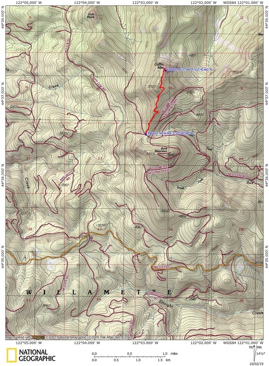
3.4 miles roundtrip. Total Ascent is 1,100, total descent is 1,100 feet. The elevation at the trailhead for Coffin Mountain is 4,781 feet. The summit elevation is 5,775. Total elevation gain is 1,051 total descent is 36 feet. 1.6 miles to the lookout.
Trail:
Coffin Mountain Trail #3392
Trail Maps:
Topo Map, Download Garmin .gpx file, Open Garmin .gpx file
Review: July 13th, 2019
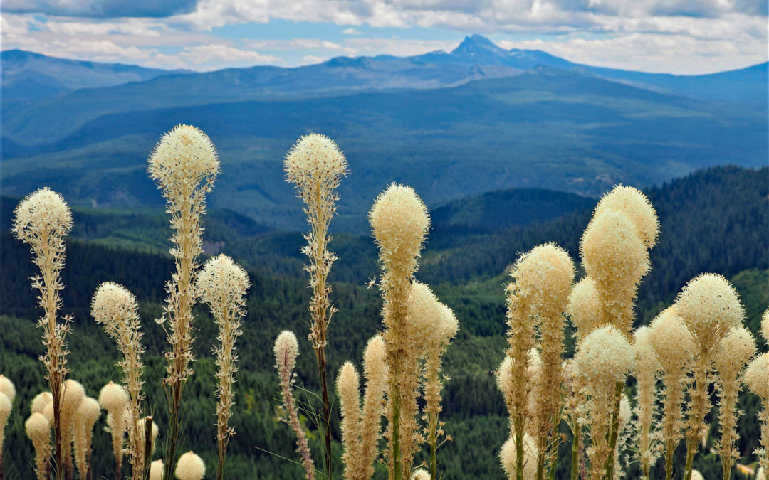
The trail enters a young forest and climbs moderately steeply from the parking lot and soon passes into flower meadows. From the small meadows continue upward through patches of forested to a series of switchbacks which brings you near the top of a ridge which runs up to the lookout. At the bottom of the ridge there is a brief view of the lookout then you wind around a hump in the ridge for more views of the top.
Climbing along this ridge your out of the trees. There are lovely views to the east and once you attain the ridgelines there are great views to the west.
Continue climbing fairly steeply up towards Coffin Mountain. The trail hits another series of switchbacks up the ridge, sometimes crossing right on the ridgeline but generally staying on the east side of the ridge.
Some days marine air from the ocean creates fog which flows in and breaks on the ridge so that the west side is in fog and clouds swirl over the ridge and dissipate, allowing views to the east.
After climbing a few more switchbacks, cross a level section of the ridgeline to a mostly flat summit and the fire lookout. Sometimes the lookout is open. There is a helipad on the summit that has painted an elevation of 5,771 feet.
Like many trails, this trail has sections that are rocky from erosion and slippery from the dust on the trail. The only cliffs on this trail are near the top and at the top so this trail should be safe for children and dogs with hiking experience. The views from the top are spectacular with views of Mt. Jefferson, Three-fingered Jack, and other mountains in the distance. You can also see to Detroit Lake when you look to the west.
Enjoy the photos!!
Gallery Pics
Switchback Steve
Recent Comments