

Vicinity Location:
The trailhead is about 53 miles east of Portland, Oregon in the Mt. Hood National Forest.
Directions:
From Portland take I-84 E for about 55 miles.
Take Exit 64 for the Mount Hood Hwy, OR-35 towards White Salmon/Govt. Camp and at the bottom of the exit ramp turn right at the stoplight. Take OR-35 S for about 22.6 miles to Cooper Spur Rd.
Turn right onto Cooper Spur Rd and drive up the winding paved road for about 2.4 miles. Turn left onto Cloud Cap Road and driver 1.5 miles to the parking area on the right for Tilly Jane Sno-Park. This parking area is below Cooper Spur Ski Area.
An Oregon Sno-Park permit is required to park during the winter months.
You can see avalanche forecasts here: Northwest Avalanche Center
National Weather Service Snow Level forecast: Northern Oregon Cascades
No bathroom at the trailhead.
Length and Elevation:
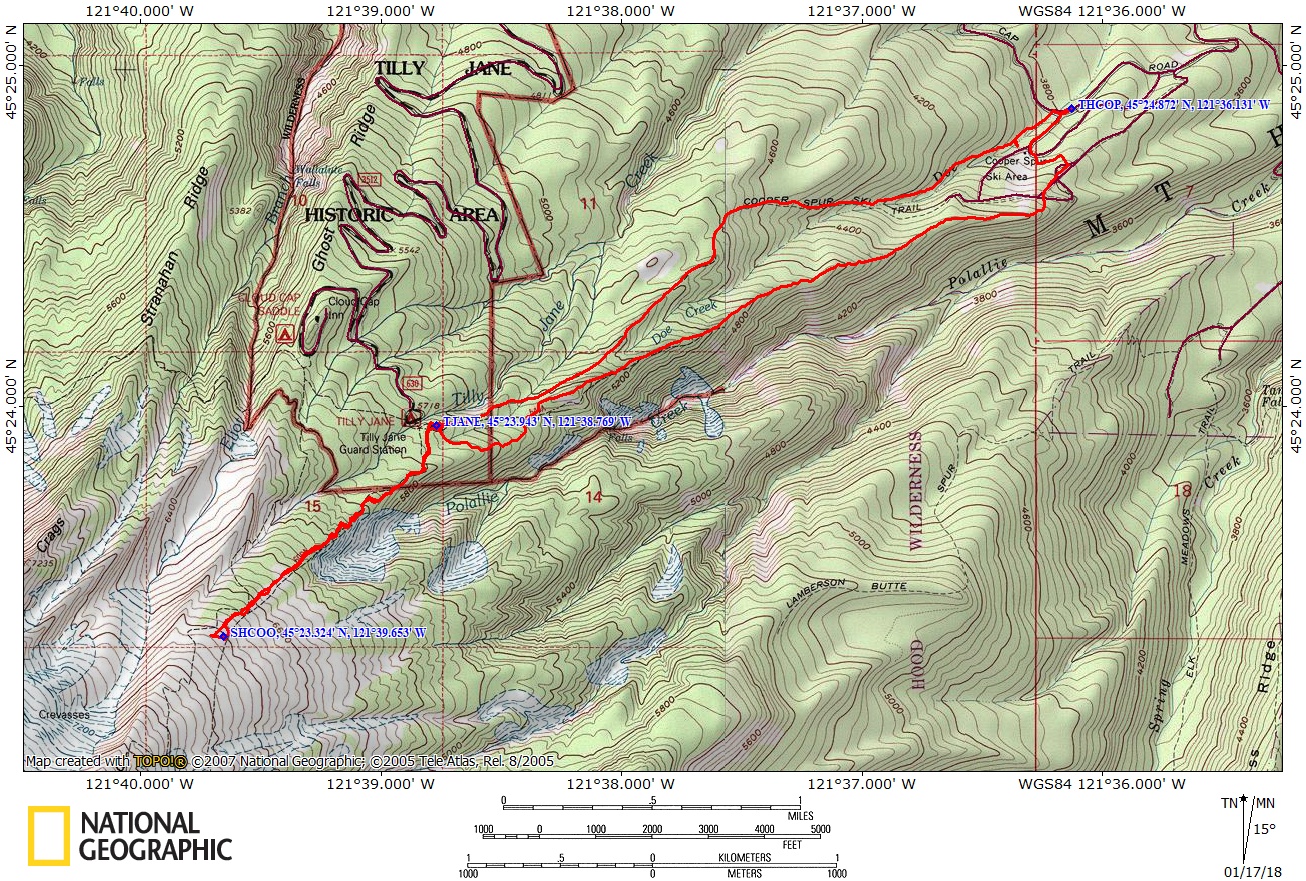
Total trip is 8.1 miles. Elevation at the trailhead is 3,800 feet. Total ascent is 3,030 feet and total descent is 3,030 feet. Highest point is at 6,825 feet.
Trails:
Tilly Jane Trail #641, Cooper Spur Trail #600B, Polallie Ridge Loop Trail #643A with connections to various trails.
Trail Maps:
Topo Map, Download Garmin .gpx file
Review: December 31, 2017, March 2, 2019
The trail starts out in an older second-growth forest of fir and hemlock and climbs moderately along a hillside. There are some seeps where logs have been laid across the trail to get past early season mud and water.
The day we hiked this trail there wasn’t much snow and the seeps made for many icy sections. As the trail got steeper the people with micro spikes fared very well while we saw some people having to crawl along the icy sections who had no traction.
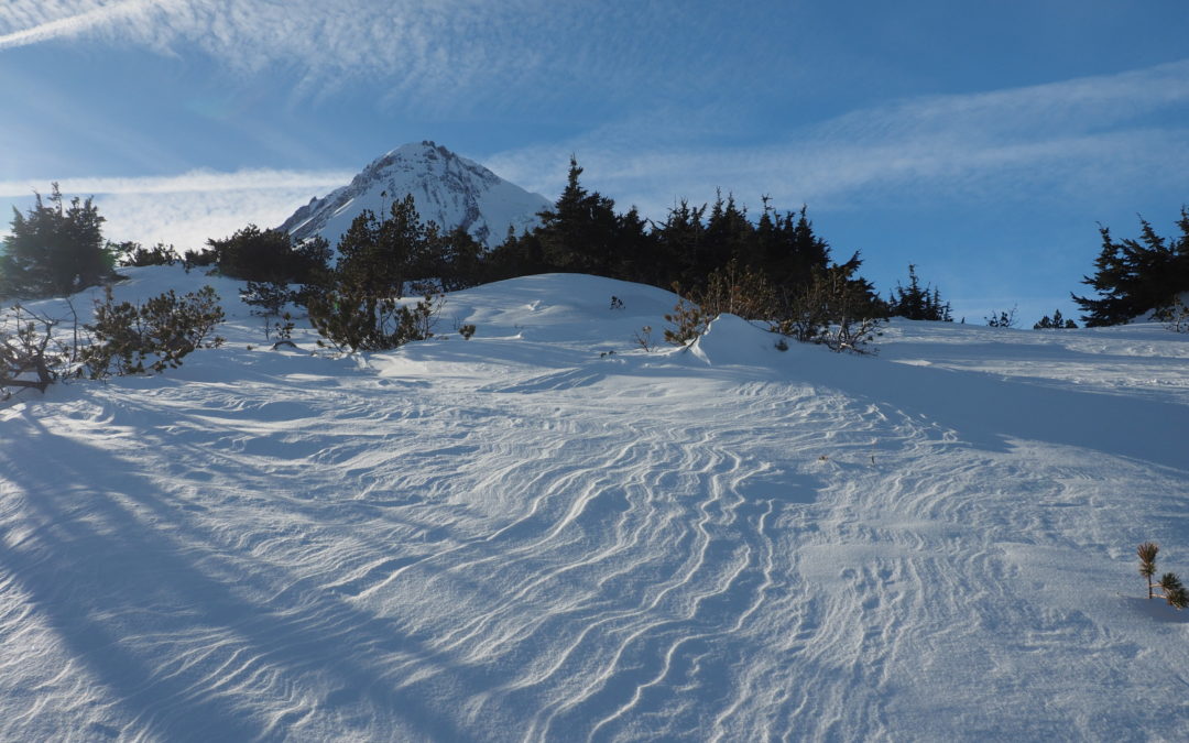
After a couple of miles you ascend to an area burned by the Gnarl Ridge fire in 2008 where grey and black trunks spear the sky and topple onto the trail. Follow a ridgeline straight towards Mt. Hood and enjoy the views of Mt. Adams, Mt. Rainier, and Mt. St. Helens as you turn aside from the ridgetop and climb up to the Tilly Jane Shelter.
The Tilly Jane Shelter is an cedar roofed A-frame built in the late 1930s by the Civilian Conservation Corps and was used extensively by the American Legion in its early days. It is just out of the burn area and is surrounded by old growth trees and about 1,000 feet below the tree line. It is operated and maintained by the all-volunteer, Oregon Nordic Club.
You have to reserve the A-frame on Recreation.gov which means it is locked when not in use. If it is open you can pop in and have a look around.
We had lunch on the picnic tables in back and if you’re out of water there is a small, steep sided canyon you can clamber down to get water.
From the shelter follow the trail behind the A-Frame which soon climbs along Polallie Ridge. There are nice views into the canyon and as the trees thin, views of far off mountains.
The forest opens up as you gain elevation and comes out of the trees about 500 feet below the Cooper Spur shelter. This is a good place to turn back if there is high avalanche danger.
From the timberline it is a moderate climb up to the rock shelter. Besides the shelter there are a few large boulders nearby where you can get out of the wind a bit. From here the views are spectacular as you have a panoramic view of Eastern Oregon, Mt. Adams, Mt. Rainier, and Mt. St. Helens. Soak in the view before heading back into the trees.
When returning, take the Polallie Ridge Trail which is on the right, just before you get to the Tilly Jane A-Frame. If you miss the junction, just head northeast from the A-Frame and the trail runs downhill right along the top of the ridge.
This trail parallels the Cooper Spur Trail and a lot of this trail is in the burn area so there will be some deadfall and brush to negotiate. There are some views of the distant mountains and Mt. Hood is in view for a long time behind you. Finally the trail drops down out of the burn area and you walk along a nice forest trail.
Continue walking down to the ski resort and head down to the lodge sticking to the side of the ski runs. Walk towards the lodge and turn right just as you get to it so that you can follow the road down to where you parked.
Practice avalanche awareness and don’t go above timberline during high avalanche conditions. During moderate avalanche conditions get the facts before you go above timberline or venture into steep canyons.
Enjoy the photos!!
Gallery Pics
Switchback Steve
Recent Comments