

Vicinity Location:
The trailhead is about 130 miles northeast of Portland, Oregon.
Driving Directions:
From Portland drive east on I-84 and drive about 100 miles east. Take exit 104 for Hwy 97 and drive about 93 miles to Yakima, WA. Hwy 97 will turn into I-82 N. Take I-82 N for 4.5 miles and take exit 33 for E Yakima Ave.
Drive 2 miles on E Yakima Ave, which will turn into W Yakima Ave then turn right onto Summitview Ave.
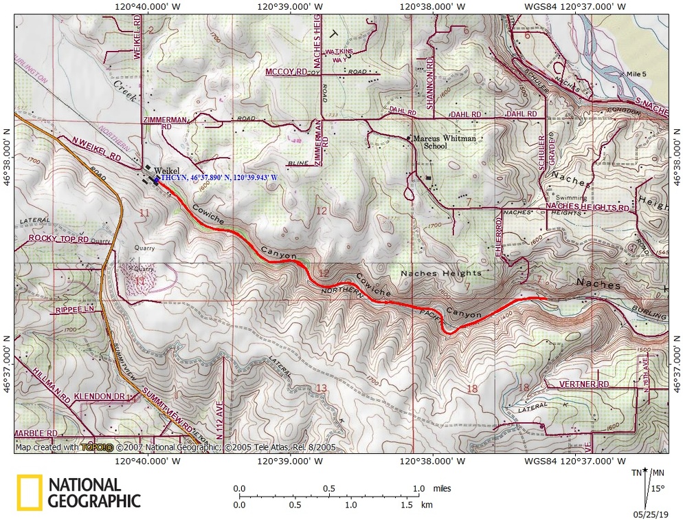
Continue for 9.1 miles and turn right on Weikel Road (signs on Summitview indicate Cowiche Canyon turnoff). Drive 0.4 mile on Weikel Road, and turn right at the sign for Cowiche Canyon.
There is no restroom at the trailhead.
Length and Elevation:
Length 5.2 miles round trip. Total ascent 175 feet, descent 175 feet. Lowest elevation: 1,320 feet, highest elevation: 1,490 feet.
Trail:
Cowiche Canyon Trail
There is at least one geocache for this trail at: N 46° 37.543 W 120° 39.202 Info at Geocaching.com.
Trail Maps:
Topo Map, Download Garmin .gpx file
Review: May 12, 2019
The trail starts just before Cowiche Creek winds enters the canyon. Pass by the Mud-o-meter sign and cross the first trestle. All the trestles have been decked for walkers, bicycles, and horses. The old railroad makes for easy walking downstream as the canyon walls grow in height.
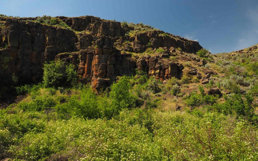
Interpretive signs along the way talk about the different kinds of lava flows on each side of the river. The volcanic cliffs look different on either side and an interpretive sign tells the floor and south side was formed by lava flows from the east 14 million years ago, while the north wall is made of andesite from the Goat Rocks to the west and is a about 1.6 million years old. The canyon has many formations of weathered and recently fractured rock. The winding route makes for very nice perspectives looking forward and backward along the trail.
In early 2015 heavy snows and rains triggered a major rockfall in Cowiche Canyon between Bridges 6 and 7. There is a sign warning of rockfall and hikers need to watch for falling rocks. Even though this area may be shady, don’t linger in the rockfall area.
Continuing into the canyon there isn’t much shade as the floor of the canyon is mostly covered with large shrubs. An occasional tree provides a bit of shade and there are benches along the trail to rest on hot days.
Continue along the very gentle downhill through railroad cuts and trestle crossings while admiring the various wildflowers like balsamroot and desert parsley that dot the trail and slopes of the canyon.
Various kinds of birds make this canyon their home such as eagles, hawks, kestrels, owls, and ravens. You might also see swallows, bluebirds, flycatchers, swifts, bluebirds, and flycatchers.
Turn around whenever you find a convenient point or continue to the end of the canyon and retrace your steps.
There have been car breakins at the trailhead so don’t leave valuables where people can see them.
This trail is for children who have experience hiking on trails with dropoffs because most of the old railroad trestles don’t have railings. Also, the combination of a hot climate, rocks, and a river create a good habitat for rattlesnakes.
Enjoy the photos!!
Gallery Pics
Switchback Steve
Recent Comments