
Note: Permits are required for use of the Dog Mountain trail system on Saturdays and Sundays between April 20 and June 16.Vicinity Location: The trailhead is 49 miles east of Portland, Oregon in the Gifford Pinchot National Forest. How to get a permit
Directions:
From Portland, Oregon, there are two ways to drive to the trailhead. If you have an extra 30 minutes then make your trip a loop drive. For the loop drive, take I-205 north across the Columbia River. Exit I-205 on HWY 14 east for about 28 miles through the town of Stevenson.
For the non-loop option, take I-84 east from Portland and take exit #44 for Cascade Locks. Take the first right turn, just after you go under the Bridge of the Gods. Pay the $2.00 toll, cross the bridge, and turn right onto HWY 14 and drive 2.5 miles to Stevenson.
Once you get to Stevenson, drive about 10 more miles east to the Dog Mountain trailhead, just past milepost 53. Parking on spring weekends is next to impossible with the small parking lot. Look for shuttle schedules.
To return, take HWY 14 west back through Stevenson, and after about 2.5 miles, turn left and cross the Columbia River at the Bridge of the Gods. The toll is $2.00 for the bridge.
After the bridge, the road loops around and intersects Hwy 30, Cascade Locks Hwy, near the base of the bridge. Turn left here and you will merge onto I-84 west in about ½ mile. Follow I-84 west, back to Portland.
A Northwest Forest Pass is required at this trailhead.
An outhouse is available near the parking lot.
Length and Elevation:
6 miles roundtrip (7 miles if you use Augspurger Mountain Trail), Elevation gain 1,000 Feet and loss 100 feet to the turn-around point. Total gain and loss is 5,500 Feet. Elevation at the trailhead is 150 feet, the summit elevation is 2,900 feet.
Trail:
Gifford Pinchot National Forest Trail 147 with connections to Trail 4407.There is at least one geocache along this trail at: N 45° 42.262 W 121° 42.267. Info at Geocaching.com
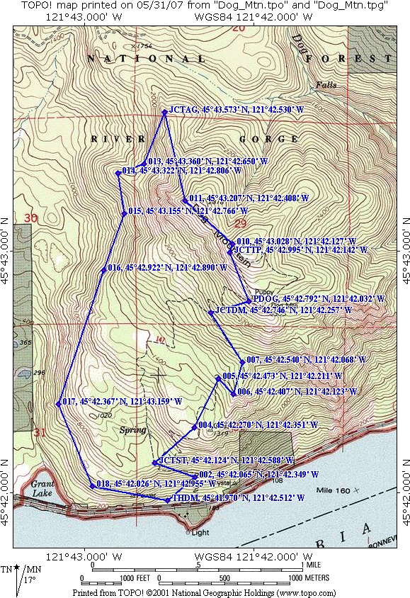
Trail Maps: Topo Map, Download Garmin .gpx file
Review: May 26, 2005; May 26, 2007; May 19, 2011, May 10, 2019
There are two ways to begin hiking to the top of Dog Mountain. Plan to take trail 147 on the right because it comes out of the trees faster than the Augspurger Mountain trail.
Trail 147 switchbacks through poison oak to a junction ½ mile up the trail. The left trail is shorter, but you’ll sweat for it. The right trail has a more gradual climb. The right fork of the trail climbs 2,000 feet in 2.5 miles to the site of a former fire lookout. People call it Puppy Dog Lookout. The old fire lookout has great views To the east is the town of Hood River.
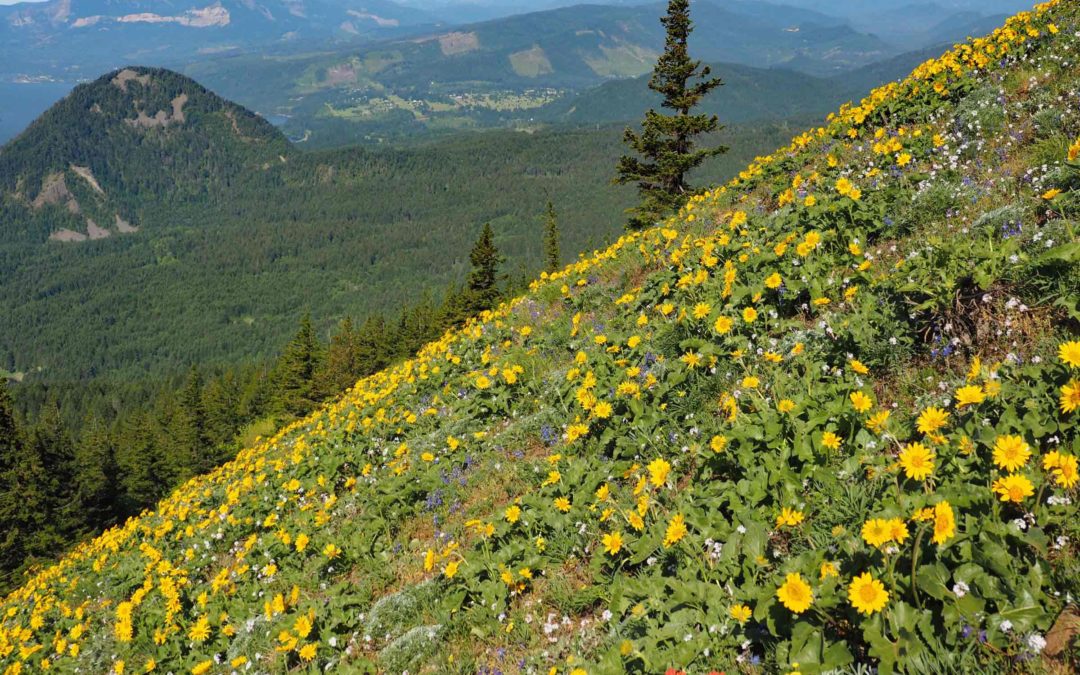
From here, you can take a trail to the right through the forest or continue up the trail on the exposed slope to the summit. The open slopes provide terrific views of the Columbia River Gorge.
On a clear day from the summit of Dog Mountain you can see Mt. Defiance across the gorge at 4960 feet high. In the distance you can see Mt. St. Helens, Mt. Hood, and, back through the trees, Mt. Adams.
In the spring there is a succession of flowers until early summer. The wildflowers usually peak around Memorial Day but the balsamroot can peak as early as the second week in May. The yellow balsamroot flowers are spectacular when their blooms peak and cover the hillside.
Either re-trace your path back to the parking lot or, if the flowers are bloomed out or it is a weekend, you will want to hook up with the Augsperger Mountain trail and make a loop. This trail is less crowded on weekends, descends less steeply than trail 147, and provides nice views of the lakes in the valley below.
From the viewing area at the top walk down about 200 feet and turn right. At the next trail junction turn right again. You will soon head into the trees for the next 4 miles. Take a left at the Augsperger Mountain trail and continue another 1.5 miles back to the parking lot.
The scree slopes towards the bottom are home to lizards and rattlesnakes. This is a great hike for a spring day. Be prepared for rain, fog, wild winds and crowds. There is no water along the trail so carry plenty on hot days.
This trail is not recommended for dogs or small children because of all the poison oak, the occasional rattlesnake along the trail, and the steep, open slopes of the trail below the summit.
With those warnings in mind, this is a “must do” spring hike. The flowers and crowds are at their peak right around the end of May.
Enjoy the photos!!
Gallery Pics
Switchback Steve
Recent Comments