
Directions:
From LaGrande, Oregon: Drive 31 miles southeast on Hwy 203. Turn left at Medical Springs, which is one or two buildings along the road.
Follow Forest Road 67 and the signs to Tamarack Campground. Continue past the campground on a gravel road and continue on the main forest road along Eagle Creek. You are now on Forest Road 77. About 5.5 miles after Tamarack Campground, turn left onto Forest Road 7740, and drive along the East Fork of Eagle Creek for about 5.4 miles to the trailhead parking lot at the end of the road.
A Northwest Forest Pass was not required at this trailhead in 2008.
An outhouse is available at the parking lot.
Length and Elevation:
As many miles as you want, Elevation gain lots and lots!
Trail:
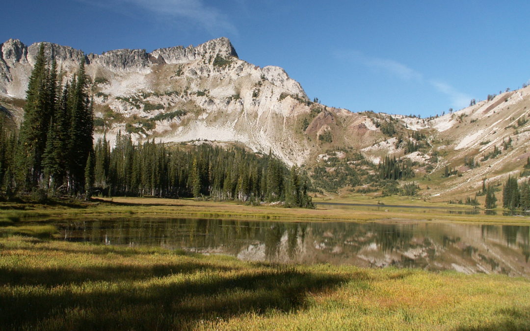
Start at East Eagle Trailhead, Trail 1910. Trip uses and connects to various trails.
Trail Maps:
Topo Map
Review: August 18, 2005
In January 2005, Drew and I talked about where our big backpacking trip would be. Drew and I agreed to backpack in a new place. We chose the Wallowa Mountains in Eastern Oregon. We couldn’t find nearly the amount of information about the Wallowas that we could find for Mt. Rainier. The Wallowas encompass Eagle Cap Wilderness and the Wallowa-Whitman National Forest. We made our plans and created our itinerary and trail profiles. We hoped we could talk others into going on our trip. We had responses in the forums claiming our schedule was too aggressive because the trails were so difficult and the altitude so high. We wondered how the Wallowas could be harder than the Wonderland Trail, so I built in a couple of day trips as buffers in case we couldn’t make as many miles as planned.
We also wanted to have a food cache midway on the trip. Wallowa Lake made an excellent choice for a halfway point because it is a small town. There really aren’t any towns on the southern trailheads. There are several places in Wallowa Lake to rent rooms or cabins. I lucked out and found that Heidi’s Cabins had a cabin for just the night we would be there. Normally you have to rent a cabin for multiple nights. In renting the cabin they agreed that I could mail our package of food and they would keep it for us until we arrived. I mailed off our food and confirmed the package’s arrival before we departed Portland. We met at work and Drew, Vernon, and I left for REI. Vernon had been looking for a new flashlight for some time and REI was the only place that had them in stock. We dropped by REI and cruised the selection of flashlights. I liked the flashlight that Vernon was getting so I bought one too. It is a Petzel Tikka XP and it has a single super-bright LED and a sliding lens that changes the beam for distance or close-up work.
We drove as far as Pendleton before we needed gas for the car and a break for us. We stopped at the 76 station by the freeway, but drove off to look for another gas station when they told us that they charge 10 cents more a gallon for credit. We gassed up at a station up the hill where the cash and credit were the same price and the price per gallon was less expensive than the 76 station to boot.
Back on the highway, our next stop was LaGrande for dinner at Bear Mtn. Pizza. After a great pizza we went over to Blue Mountain Sports and looked around. Vernon wanted some nylon cord for his hammock tent.
We looked at the map awhile deciding what direction to take. The directions to the trailhead weren’t very good. Our book said to get on 203 and turn before Medical Springs but it looked like we needed to turn right at “downtown” Medical Springs. Then the directions said to follow the signs to Tamarack Campground. I guess someone took down all the signs because we couldn’t see them.
We saw a lot of deer in the road on the way to the campground. Tamarack Campground had only two spots left and we got one by Eagle Creek. We got our tents set up by headlights and flashlights and remarked how the air wasn’t hot at all. While we were driving to the campground, I was afraid the weather would make it too hot to sleep. I had just gone to bed when Vernon told me to come back out and look at the moon on the water. I got my stuff back on and followed him down a trail to a bridge across Eagle Creek. It was very nice to see the full moon shining on the splashing creek.
The next morning, August 19th, was cold and clear when we got up at a little after 6 am. We rousted around to make breakfast and the campground host dropped by and chatted for a while. He seemed friendly but I think he mainly wanted to check our permits. He went back to his spot to get his morning campfire going and we resumed our breakfast routine of making oatmeal and hot chocolate. We were watching the morning sun reach down to us but we saw it would take too long to warm the dew off our tents so we decided to pack up, mash the tents into the back seat, and dry them out at the trailhead.
We drove the winding dirt road towards the East Eagle trailhead but we had to go slowly. The sun shone right into our eyes and we had to pull over once to let a big excavator on a wide flatbed slide past us. We passed a spot where a sign proclaimed scenes from John Wayne’s “Paint Your Wagon” were filmed here.
We found the trailhead without a problem and got the tents out to dry, used the pit toilet, and packed up. We hit the trail about 9:30. The first few miles of the trail are mostly in the woods and the trail isn’t very rocky. The trail got rockier and passed through meadows as we went upstream. We passed a group of Boy Scouts out for a dayhike. We could hear them for quite a ways before we saw them. The trail passed two streams coming off of Jackson Peak and both streams disappeared into the granite gravel before they reached the trail.
We stopped for lunch at a shady spot with granite rocks to sit on and enjoyed the views. We were throwing rocks into the creek below when we heard the Boy Scouts coming. We didn’t really want to talk with them and decided to get moving again before they showed up. We took off up the trail and left them behind.
At about 1:30 we came to an unsigned trail junction. We had to find out if it was the trail to our first campsite at Hidden Lake. We followed it across Eagle Creek and then we were pretty sure it was the right trail. Drew turned on his GPS, we compared map coordinates to the GPS coordinates, and decided we had to be on the right trail. The trail soon passed a good a campsite that my sister had told me about. We had this trail as a fallback location in case we got delayed somewhere. We passed up the campsite and kept on towards Hidden Lake.
The trail grew steeper and rockier and pretty soon it was going straight up the draw. As we got higher, the trail paralleled a lovely brook. When we got to Moon Lake we knew we were close to Hidden Lake. We crested on more rise and there was a small stream but we couldn’t see the lake. We followed the stream to a meadow and decided the lake had to be to our right. We crested one more ridge and saw Hidden Lake. We soon found a campsite and made camp for the night.
We were pretty tired after our hike. The lake is at 7,200′, which is more than 2,600′ above the trailhead. We took a little nap, made a campfire, and fixed dinner. After dinner we sat around the campfire and talked about the day and the days ahead. We decided the bugs weren’t bad at all. There were only a few mosquitoes and no yellow jackets. Once we went to bed it took only a couple of minutes before Drew was snoring in his tent.
The next day, August 20th, dawned clear and cool. My thermometer showed 38 degrees when I got up. Drew and I woke up about 6 am. Drew got our Ursacks while I wandered around and took some pictures of the misty lake. We fixed breakfast and woke up Vernon. We could hear horses whinny at the far end of the lake. I noticed that Vernon had left his pack and boots out on the ground but lucky for him they didn’t really get damp.
We finished breakfast and hung the tent fly’s in the sun to dry. The sun hit our camp early and it got warm quick. We did our daily duty and finished packing up. We broke camp about 8:45 but I slowed us up when I stopped to get pictures of some ground squirrels near the camp.
I had read you could bushwhack from the south end of the lake down to the Frazier Pass trail. We took a compass bearing, used a mountain peak for a reference, and started across a meadow. We soon found the beginnings of a trail and it soon became a full-fledged horse trail. I couldn’t find this trail on any maps during my pre-trip research. It was an easy walk down the rocky horse trail until it branched out and petered out in a small meadow. We followed it as best we could and it joined up with the Frazier Pass trail just above where it crosses Eagle Creek. We soon came to the junction to Horton Pass and turned left up the valley.
The trail wasn’t too steep or rocky. We went in and out copses of trees whit nice views down the valley. Then we came to the first switchback. Doubling back made me feel as if the trail was drawing back its fist to strike us. We got the 1, 2, 3 count of no shade, rocky trail, and steep switchbacks. We had a nice rest at a cirque, which is the head of Eagle Creek. Then it was up, up, up, to the pass. We reached Horton Pass just after noon and took pictures of the plaque describing the pass. We stashed our packs and headed up to summit Eagle Peak. This is one of the nicer trails in the area because horses don’t us it. We reached the top and had incredible views of the distant mountains, and clear into Idaho. At 9,500′ you get dizzy when you stand up too fast. The top of Eagle Peak is a big area and several people were wandering around. One group was cooking lunch and talking on a cell phone of all things. The smell of food made us pretty hungry, so we headed back down to our packs taking pictures along the way. We got lunch and consulted the map. Drew had asked for directions back on the top from a hiker, but we decide he had given us bad advice.
We followed our map down from Horton Pass into the Lakes Basin. Vernon voted to hike farther than our original destination so we would have a shorter hike the next day. We continued past our planned stop and found a very nice spot at the beginning of Horseshoe Lake.
We set up camp and I found a good spot to get into the lake for a swim. Drew came down but the water was too cool for him to want to go swimming. Later Vernon came sown as washed off his trail dust. Vernon found and ant that had made a fatal mistake by climbing into Vernon’s sock the previous night.
The trails in the Lakes Basin are either rocky and/or covered by a ½ inch thick layer of dust. You had better not be allergic to horses because I hesitate to think how much of the dust is made from old horse manure. We hadn’t seen many horses so far, but there was plenty of evidence they had passed. We started a campfire and fixed our dinners. We were all tired and turned in a little after 8 pm.
Sunday, August 21st dawned and the temperature seemed pretty warm considering the lake is at 7,400′. Drew and I woke up about the usual time and I woke Vernon up in his tent hammock. I checked our food and saw that I didn’t really have any snack food left. Luckily for us, Drew had extra snacks for the day for us. In fact, snacks were about the only thing Drew had left. I gave him a packet of hot chocolate and we shared our oatmeal too. After breakfast, I took pictures of Eagle Cap and a ridge behind our camp.
We left camp about 8:10 and moved out quickly because the trail was downhill. We met at least three groups of packhorses and one group was blocking the trail. We couldn’t get by until the riders finished snacking on huckleberries along the trail. Vernon decided this was a good place for a break, so we had snacks and huckleberries. We met some hikers and learned they were walking to Unit Lake and Horseshoe Lake. They were lightly loaded because the pack train we met earlier had all their gear.
The forest along the trail has numerous dead trees. All the deadfall would make going cross-country next to impossible. The stream was chocked with trees in places. The dusty trail rolled up and down along the river and passed a humming power generator.
We arrived in Wallowa about 12:30 pm and found the cabin that we had rented for the night. I rented Heidi’s cabin #7, which is located about ½ mile from the trailhead. Our cabin was being cleaned for us and the staff had kindly brought over our box of food that we had mailed for our re-supply. We got our keys, registered, and went to the general store for lunch. The meals were reasonable and the micro-brews were $3 a pint.
Back at the cabin we sat around for a bit then walked over to an ice cream stand for a well-deserved snack. We bought tickets for the Mt. Howard tram and boarded a gondola for the ride to the top. Mt. Howard is at 8,500′, which is more than 4,000′ above Wallowa Lake. People here feed the wildlife way too often. The chipmunks are so numerous that you’re afraid that you’re going to step on one of them. When you sit down they will climb right on you looking for food. Vernon was a little frightened when they jumped on him, but the chipmunks have lost almost all of their fear of people from being hand fed so much. There are almost as many ground squirrels as chipmunks, but the ground squirrels are a little more wary of people and stay out of your way.
There are great views from the top and we could see Eagle Cap. We could also see smoke from the School Complex as well as some fires in Idaho. Most of the fires we saw were from the School Complex, which had burned over 40,000 acres. The smoke mad the horizon quite hazy.
Walking back to the tram, we saw several deer resting and a place where hang gliders launch themselves. We saw more wildlife on Mt. Howard than we had seen on the whole trip.
Back at the cabin, we hung around and watched T.V. then unpacked our food box. Drew had brought extra food (some he should have had the night before), so he planned to leave some behind. We ate some of it, Vernon took some of it, and we threw a bit away. Dinner was high on the agenda and I found out that Russell’s By the Lake had take-out food and the restaurant was pretty close to our cabin. Drew and I went to get food while Vernon took a shower.
It was great to relax on the couch and have dinner and a couple of beers. The television news talked about the tinder-dry conditions in the area. Starting tomorrow, all campfires were banned in the national forest and the Eagle Cap Wilderness. We had enjoyed our campfires and were sorry we couldn’t have them for the rest of the trip. We had Haagen-Dazs for dessert. Drew told us that he once had an apartment across from the Haagen-Dazs factory in New Jersey. He reminisced about eating a lot of miss-filled containers of Tin Roof Sundae. We made ice cubes to put into our water bottles the next morning and went to bed. I got the soft bed, Drew got the really soft couch, and Vernon got the hard floor. Thank goodness the go-carts next door stopped racing at about 9:30 pm.
Monday, August 22nd, dawned somewhat cloudy and cooler. I had slept pretty well, Drew said he didn’t sleep well, and I think Vernon can sleep well almost anywhere. We made our oatmeal for breakfast and go packed. Drew looked out the door and saw a young deer in the front yard. I decided to see how socialized it was so I opened the front door and stepped out onto the porch. The deer took a step away and kept eating the grass. Drew came out and we sat on the porch with the deer eating grass about six feet away from us. After awhile the deer moved off into the yard and we went back inside to finish packing. We added our fresh ice cubes to our water bottles, finished packing, locked the door, and walked right into the smell of bacon being fried. How we wished we had had bacon and eggs for breakfast instead of oatmeal.
We walked back to the trailhead and passed a small campground owned by PacifiCorp. We met a group of three families that stay there every summer. We thought the campground could be used on a loop hike but I don’t know how to manage a food-drop while staying at the campground. The phone reservation number for the campground is 541-432-4902. I asked the campers where Wallowa Falls was and one man thought it was just over the hill. We walked up the hill and found ourselves on the edge of a canyon. We walked along the trail and found the “falls”. I think the waterfall was all of five feet high, and down at the bottom of a canyon.
We weren’t impressed and soon rejoined the trail from the Lakes Basin and went back down to the power generating station and found the trailhead to Aneroid Lake. Two squirrels chattered an alarm, as we started uphill. It sounded like they were warning us not to go. I wondered if their alarm was a bad omen of things to come.
The first part of the trail was quite good, but after awhile the trail turned back into the familiar dusty, rocky trail. We got some good views of Wallowa Lake as the trail switch backed up the mountainside. Once the trail turned and went up the valley, it became sandier because the surrounding rocks changed from basalt to granite. We took a break in a small meadow a couple of miles up the trail.
I needed to stop so that I could bandage a hot spot on my foot. Soon after our break, the trail came to a small lake formed by a dam. We decided this lake was the inlet for the water that supplies the powerhouse far down the mountain. That generator must have been so loud because the lake must be almost 1,000′ higher than the powerhouse.
We continued along the valley where the trail was mostly in the trees. The trail gains elevation almost the whole way. We passed a big meadow with a stream meandering through it and a picturesque mountain ridge for a backdrop. I took pictures until my camera batteries died, and then we moved on.
I accidentally chose a mushy meadow to have lunch in and pretty soon the flies were bothering us. I got out the trail bread that I had made for Vernon and me and it was as hard as a rock. I tried hammering it on a stick but it broke the stick. I took the trail bread and put it into a Ziploc bag and added some water. The outside of the trail bread softened a bit and we could gnaw off the mushy part. We put the trail bread back in the bag to soften it up for later.
Back on the trail we soon passed another lovely meadow. I felt bad that I had picked such a crummy lunch spot. We next came to a small lake and we knew we were close to the lake. We reached Aneroid Lake after another ½ mile. We went to the south end of the lake to look for a campsite. We found a wonderful campsite at the edge of the Halton Company property. The campsite had a great view of the lake and there was an ice-cold spring nearby that we used for water. We got our tents set up and debated about a dayhike. The weather had been cloudy all day and some of the clouds looked pretty gray. We decided to hang around the lake and stay close to camp.
A couple hours later we heard the first roll of thunder. We hoped the storm would go on by, but the thunder got louder and more frequent. The rain started and we sat under some trees and watched the lake. We saw the mountains across the lake lit up by lightning and the rain picked up causing us to head for our tents. It rained off and on for about 90 minutes but there was never a downpour. I worried if the rain would run down the hill and under my tent. The rain only wet the ground a little, tapered off, and stopped.
We got out of our tents and made dinner. We cleaned up after dinner and met Harry, the caretaker of Camp Halton. Later we went over to his cabin and he told us about how he hires a mule team to bring in his major supplies. I asked him about all the dead trees and he told me that there was in infestation of spruce bark beetles about 20 years ago that killed all the trees. He has spent many summers cutting down the dead trees and clearing the deadfalls off the trail. As it got dark we watched a mule deer come into the clearing below the cabin and Harry said there used to be a lot more wildlife in the valley than there is today.
We thanked Harry for his hospitality and the use of his outhouse, then returned to camp and went to bed. It was very pleasant falling asleep with the sound of a small stream nearby. During the night Drew and I heard something outside near our tents but we couldn’t tell what it was when we checked the next morning. I decided the warning from the squirrels wasn’t a bad omen after all. It had been a great day for hiking uphill.
Tuesday, August 23rd, began with perfectly clear weather. As we made breakfast we watched the sunlight up the top of the mountain range across the lake, creep down to the distant shore, and slowly light up the lake. We took stock of our food cache and nothing was amiss so we walked over to the spring to get water for breakfast. That water has to be the coldest water I’ve ever gotten from a spring. I bet it wasn’t warmer than 34 degrees. Your hands went numb when you washed them in the water.
After breakfast we had to endure the cold and zip off our pant legs and take off our fleeces for hiking. We set off uphill towards Tenderfoot Pass. Just before we got to the pass, we dropped our packs and walked the ½ mile down to Jewett Lake. You can’t see the lake from the trail but Harry told us how to find it and that the wildflowers were still in bloom at the lake. We dropped down to the lake and surprised some campers there. I got some nice wildflower pictures and Drew and I headed back to our packs.
Vernon had stayed above the lake and was practicing with the signaling mirror on his compass. When I saw it, I couldn’t believe how bright it was. I bet you could see it miles away. We were going to hike up to Pete’s Point but the weather was getting cloudy and we didn’t want to encounter a thunderstorm above tree line.
We donned our packs and proceeded over Tenderfoot Pass. The trail dropped down some to a trail junction. Our trail started climbing again to Polaris Pass. The trail went up and up. There was a cold wind blowing so we stopped in a grove of trees for lunch. My Logan Bread had turned into Logan Brick. I put two of the bricks in a bag the previous night and had added water to soften them. The outsides were mushy but the core was still rock hard. Vernon and I gnawed off what we could and put the rest back in the bag with more water holding out hope the bricks would soon soften. Drew’s tortilla with peanut butter and jelly looked pretty good. Drew had an extra energy bar that he gave to Vernon. We looked way back down the trail and saw a lone backpacker following us. We continued up to Polaris Pass and never saw him again.
It is an incredible view from Polaris Pass. I think the snow-speckled granite mountain range across the valley to the north look like the Alps. It was a perfect view with the deep blue sky and wispy clouds. Even though the cold wind was blowing through the pass, we put on our fleeces and walked on the ridge a bit. On a distant mountainside we saw some
mountain goats but soon they walked out of sight.
We could see the night’s destination in the far distance so we headed down from the pass. At first we stayed on the trail but some sections of it were in pretty bad shape. Then we followed a steeper trail down. Soon we were descending in the scree almost like an escalator. We dropped about 400′ in five minutes. The trail seemed to switchback down forever. Drew and I were out of water and could see a stream down below. There was no way to get to the stream because it was in a deep ravine. Finally there was a path to a cascading stream and we filled up our Platypuses and admired the Indian Paintbrush and Mimulus. This part of the trail was not well maintained. The trail detoured around a couple of fallen trees. I think it is a shame there isn’t enough money to perform even minimum maintenance on the trails each year.
We took two more shortcuts to cut off the switchbacks, but it was one too many. I quickly realized that I had led the group below the last switchback. We started the slow climb back up the steep hillside to the trail. Drew slipped on a stick and hurt his ankle. When we got back on the trail he said it seemed okay. We reached the trail junction for Wallowa Lake and Frazier Lake and turned left to Frazier Lake.
Immediately we could tell horses frequent the trail. We were again walking in a deep rut and negotiating through large rocks. Soon after the junction the trail begins to follow the Wallowa River and the trail follows the river all the way to Frazier Lake. We saw a grove of trees that had been hit with a huge avalanche last winter. 20 and 30-foot tall trees were all bent away from the mountainside and the largest trees had been snapped off like broken Popsicle sticks. It looked like the avalanche had remained until a month ago as the broken trees had only recently been cleared from the trail. As we were looking at the hillside, Vernon noticed a spot and said it was a cave. We looked and though it might be. Vernon asked if we could go look and it seemed okay.
It turned out to be a log longer walk up the hill than it seemed to be from the trail. We finally got there and it turned out to be a cave about 30 feet high at the front and about 30 feet deep. At the end was a shaft that went up into the rock. It looked like some water came into the cave when it rained, but not a lot of water. The slanting floor of the cave was muddy but not rocky. We looked around a bit in the cave and then made our way back to the trail, picking up some interesting rocks along the way. When we got to Frazier Lake, we just missed getting the last good campsite. We talked to a group of campers who said there wasn’t anyone at Little Frazier Lake so we decided to continue up the trail and camp there.
We found a good campsite right at the outlet to the lake. There was a cold wind blowing and we put on extra clothes to keep warm. We set up camp and explored around the lake. We could see part of the trail up to Hawkins Pass and it looked steep. Walking around we saw a really nice waterfall on the west side of the lake. On a high mountainside across the valley we saw six mountain goats grazing in the afternoon sun.
After dinner Vernon said he had been kind of cold sleeping the past couple of nights. The lake is at 7,500′ and we could tell tonight was going to be the coldest night yet. We gave Vernon tips on keeping warm, like putting on his rain pants. I also gave him my fleece to wear to put over is fleece. We went to bed listening to the wind blowing in the night.
Wednesday, August 24th, we woke up to frost on Drew’s backpack. Our thermometers said the temperature had dropped to about 29 degrees. Drew and I got all our clothes on to keep warm but I didn’t have my fleece. Drew and I made breakfast, let Vernon sleep in for ½ hour, and then woke up Vernon for strawberry Cream of Wheat for breakfast. Of course Vernon didn’t want to get out of his bag because it was cold and the sun was shining only on the distant mountaintops. We got breakfast out of the way and made ready for our dayhike to Prospect Lake and Glacier Lake.
We carried our packs uphill and to the right of our campsite looking for a place to stash our packs. We discovered an even bigger campsite than where we stayed last night. We walked just past the second campsite and stashed our packs in some trees. From there, we cross-countried up the granite hillside heading south. We passed through some sloping mountain meadows and under a very old tree. The way was steep but not too tough. We came out just above the east shore of Prospect Lake.
Drew spotted a snowfield and scraped 8-24 in it to show we had been there. From Prospect Lake, we side-hilled over to nearby Glacier Lake. Both of these lakes are aquamarine jewels and the granite mountain backdrops are spectacular on a clear day. Somehow Drew had left his camera in his backpack so I took plenty of pictures. While we were at Glacier Lake we saw the lake had rainbow trout. Vernon threw in a little stick and a fish went after it as soon as it hit the water. We saw more trout as we walked along the lake. They all were about 8 inches long but there may have been bigger fish farther from shore.
We admired the views for awhile longer at the lake then headed down the trail back to Frazier Lake. We got back to our packs at Little Frazier Lake about 11:30 and started towards Hawkins Pass, an elevation gain of about 1,000’ in two miles. Climbing the steep trail up to Hawkins Pass, you see walls of fractured granite. Just where the trail passes the lake is a refrigerator-sized block of granite that had tumbled onto the trail and blocked it. The rock looks like it just fell yesterday. It is a little intimidating when you are walking on sections of the trail blasted out of the same rock. There are millions of tons of granite blocks up above, out of sight. You hope none of those blocks ever tumble down on top of you.
The sky didn’t look threatening but we wanted to get over the pass and back down before any afternoon thunderstorms could catch us on the treeless trail. We crossed Hawkins Pass about 12:30 and the trail went down, down, down. Suddenly there were hundreds, if not thousands, of crickets trying to hop out of our way. This went on for at least a mile. These crickets are big and ugly. They are the things nightmares and horror movies are made from. Finally we got away from the crickets and the trail went into the woods.
We made good time and we remarked how the trip would be really steep and nasty going the other way. We came to our next junction, Cliff Creek, just after we crossed the South Fork of the Imnaha River. Vernon saw a 24-inch fish swimming idly in the current. It looked like a rainbow trout. It was hard to believe a stream so small could support a fish so big. The stream wasn’t more than 10 feet wide and a couple of feet deep. We had rock-hopped across the stream without any problem. We continued up the trail in the woods and passed through a forest killed by spruce bark beetles. It was sad to see so many dead trees. The trail followed close to the North Fork of the Imnaha River and then rose above it.
We stopped across from Red Mountain and consulted our map and saw we had less than two miles to travel to reach where we planned to camp for the night at Crater Lake. We thought there wouldn’t be any water, but we crossed several year-round streams. One stream had the prettiest waterfall with the water spilling over rock layers. I stayed almost ½ hour taking pictures and admiring it. I had just started up the trail when I met Vernon coming to find me. I apologized for holding them up and we found Drew waiting for us at the junction to Crater Lake. We got to Crater Lake and met one other group of three people camping there. They didn’t know much of anything about other campsites so we scouted around until we found one near the outlet of the lake. I cleaned some horse manure out of camp and scraped a place for my tent. Drew set up his tent and Vernon found two good trees to set up his hammock tent.
Over dinner we remarked that the only people we had seen on the trail that day was early in the morning when we met a couple on the trail between Glacier Lake and Frazier Lake. After dinner we explored around the outlet of the lake and discovered the outlet was man-made. The local irrigation district folks had dug a trench, laid a pipe and gate valve, and filled in the ditch. It looked like the first pipe had been laid in the early 1900’s and then renovated in 1963. The valve was wide open and water was gushing out of the pipe. Crater Lake isn’t really big and the open pipe lowers the water level about a foot per day. Even though the lake elevation is just over 7,600’, the night was warm.
Thursday, August 25th, our last day! Today’s hike is to be all downhill with an elevation loss of almost 3,200’ in six miles. We broke camp and headed out on a winding trail through open meadows. We saw some grouse but couldn’t get any good pictures of them. The trail began switchbacking down a ridge. At first the trail was loose rocks but then the brush closed in. After a time the trail narrowed and the head-high batted you from both sides. The trail dust here was the worst we encountered. Drew was in back and couldn’t see the rocks in the trail from the dust cloud Vernon and I raised. We agreed this rutted, rocky, dusty, brushy trail is in the top-ten worst trails that we have ever been on. There is no way any of us would EVER want to walk uphill on this trail. Thankfully all bad things come to an end and we descended out of the brush into the trees. From here the trail was a pleasant walk and before long we were back at our starting point a week ago. There were two other cars at the trailhead and our car was pretty dusty. I had left a window rolled down a tiny bit and a mouse had gotten into the car. It started to make a nest in the glove box and sampled Vernon’s Butterfinger candy bar. The mouse didn’t make it into the trunk so our crackers and other snacks were fine.
We congratulated ourselves in completing our trek without major blisters, injuries, or sunburns. Vernon was pleased because he only had to dig catholes twice. There are some of the areas we passed through that I would like to see another time with springtime flowers.
Enjoy the photos!!
Gallery Pics
Switchback Steve
Recent Comments