

Vicinity Location: 44 miles east of Portland in the Mt. Hood National Forest.
Directions:
From Portland take I-84 East to the Wood Village, exit (16A). Head south and turn left onto NE Burnside Rd. Heading East, Burnside will merge into Highway 26.
Follow Hwy 26 for 26.8 miles to Zigzag. When you drive past Welches, you are getting close to Lolo Pass Road. East Lolo Pass Road is just after the Hoodland Fire Station and Salmon River Road, which are both on the right and the Zigzag Mountain Store on the left. Turn left onto E. Lolo Pass Road and follow the twisty paved road for about 4.2 miles and turn right onto a paved Forest Road 1825, just a little past the end of the road maintenance sign.
About 4.9 miles from Hwy 26, turn right and cross over the Sandy River. At about 5.3 miles is a brown road sign. Continue straight, towards the Ramona Falls Trailhead, passing the junction on the right.
At 6.6 miles is another junction and sign for the Ramona Falls Trailhead. Turn right at the junction with Forest Service Road 1825 and continue on the single lane paved road for about 1.6 miles. These last 1.6 miles of the road have some incredible potholes that will cause you to creep through them.
The gravel parking area isn’t very big and looks like it fills up on nice weekend days.
Northwest Forest Park permits are required and a wilderness permit needs to be filled out.
There is a seasonal bathroom at the trailhead.
Length and Elevation:
Elevation at the trailhead is 2,454 feet, distance 9.5 miles roundtrip, Gain of 2,352 feet and loss of 319 feet to the summit. Total elevation gain of 2,550 feet, total loss of 2,550 feet.
Trail:
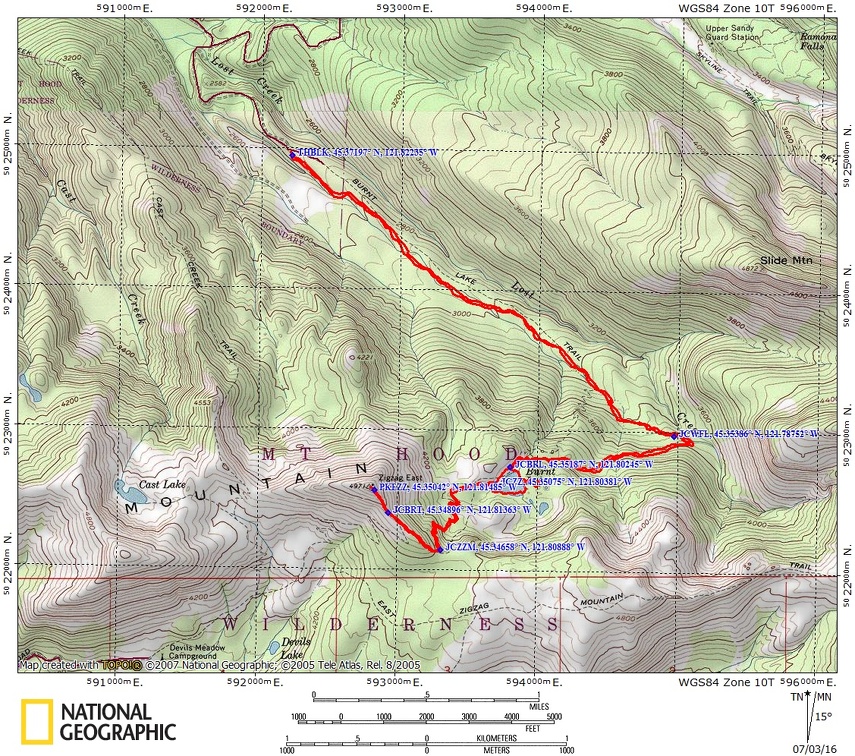
Burnt Lake Trail #772, East Zigzag Mtn Trail. Connections to Zigzag Mountain Trail #775.
There is at least one geocache for this trail at: N 45° 21.086 W 121° 48.093 Info at Geocaching.com.
Trail Maps:
Topo Map, Download Garmin .gpx file
Review: August 17, 2014
This is one of the most popular trails on the west side of Mt. Hood so be prepared to meet plenty of people and their dogs.
The Wilderness Permit box is just a couple hundred feet down the trail and you are required to fill out a permit and post part of the permit on your pack.
The first 1.5 miles of this trail is a delightful walk on a gently climbing, wide trail through second growth forest of hemlock and cedar with undergrowth that varies between bunchberries, apple clover, elderberries, vanilla leaf, ferns, huckleberry bushes, and other bushes that don’t get very tall. The fairly dense canopy the trail has slanting shafts of sunlight piercing the canopy and scattering across the trail. Lost Creek makes a nice sound off to the right that is never really out of earshot and mountain ridges protect the trail from any highway noise.
Cross a small creek then start climbing more steeply up along a hillside where the trail breaks out of the forest for a short stretch then goes back under the tree-cover. Along the way there is a junction leading down to an overlook of a small cascading waterfall.
Just before reaching the lake, there is a junction on the left that leads to a user path to campsites around the lake. Walk along this for some views of the lake walking farther around Burnt Lake, there are some other small ponds past the far side of the lake but they aren’t noteworthy.
Come back to the junction and continue about .1 mile to the next junction. Take the trail to the left for a short distance for places where you can walk down to the lake. The nicest views of Mt. Hood are from this side, the west side, of the lake.
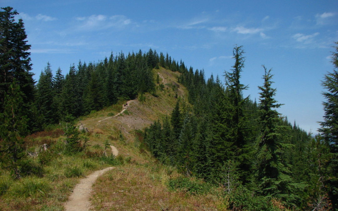
Go back to the junction for East Zigzag Mountain and turn left to take you uphill. The trail ascends gently for a bit, then the trail steepens, crosses a couple of small creeks, then climbs up about a dozen switchbacks, and reaches the junction of Zigzag Mountain Trail. Continue to the right and walk up the steep and rocky trail follows the ridgeline up to another junction. The trees are becoming sparse along this section of the trail and there are mostly obscured views that can be seen through the trees.
It doesn’t take long before you come out of the trees and walk along the edge of a cliff to another junction. Continue along the ridgeline up the steep slope to the rocky top of East Zigzag Mountain. On a clear day there are great views of Mt. Hood and Burnt Lake. Enjoy the views from a shady spot, then return the way you came.
Enjoy the photos!!
Gallery Pics
Switchback Steve
Recent Comments