

Vicinity Location:
The trailhead is about 49 miles southeast of Portland, Oregon in the Mt. Hood National Forest.
Directions:
From Portland take I-84 East to the Wood Village, exit (16A). Head south and turn left onto NE Burnside Rd.
Heading East, Burnside will merge into Highway 26. Follow Hwy 26 past Government Camp and exit on Highway 35 to Hood River.
Follow Hwy 35 for 6.6 miles, drive under the highway overpass for Mt. Hood Meadows.
Drive about 1.2 miles past the overpass and turn left into the Mt. Hood Meadows parking area, for a total of 7.7 miles from the Highway 26 and 35 junction. Drive .3 mile to the trailhead which is along the road.
Seasonally there are outhouses at the trailhead.
The parking area is large enough to accommodate a lot of cars.
A Northwest Forest Park permit is required at the trailhead.
Length and Elevation:
17 miles round trip. Elevation at the trailhead is 4,460 feet. Elevation gain is about 820 feet and the loss is 210 feet to the shelter at Elk Meadows.
Total gain is 3,450 feet and loss is 3,450 feet. Elevation of Lamberson Butte is 6,633 feet. High point is about 6,633 feet.
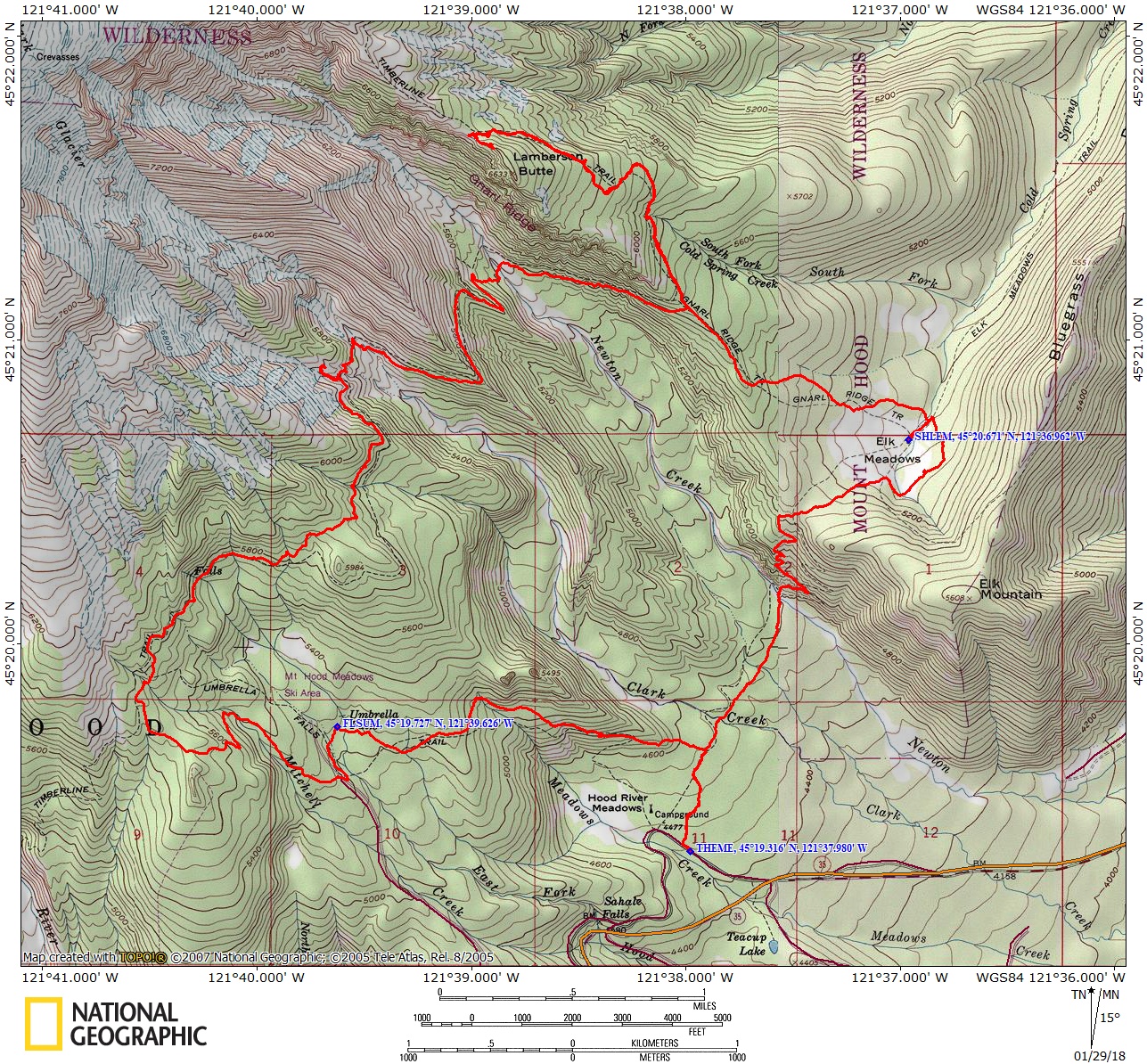
Trail: Elk Meadows Trail #645, Gnarl Ridge Tie Trail #652A, Gnarl Ridge Trail #652, Timberline Trail #600, Umbrella Falls Trail #667. Connections to Newton Creek Trail #646, Bluegrass Ridge Trail #647, Bluegrass Ridge Tie Trail #647B
There are no known geocaches along this trail at the time of this review.
Trail Maps: National Forest Service Map, Topo Map, Download Garmin .gpx file
Review: July 22, 2017
This trail becomes dusty during dry periods because of the fine volcanic soil. The first mile of this trail is sandy and relatively flat as you make your way towards Newton Creek. At .4 mile from the trailhead is a trail junction for Umbrella Falls. Continue straight ahead and cross Clark Creek on a large log bridge.
The trail next crosses a few small creeks, and continue straight at the junction of Newton Creek Trail. The bridge across Newton Creek washed out several years ago but there is usually a makeshift bridge across the creek. At the time of this review there are a few small logs to cross on. The bridge is just above the creek so any flooding will wash away the bridge.
Once across Newton Creek, find where the trail enters the woods again and the tread becomes covered in a thin layer of forest debris which eliminates the dust. The trail immediately starts switchbacking up the ridge on the north side of the creek.
The switchbacks don’t last very long and you reach the plateau, walk through the forest for a bit and 1.75 miles from the trailhead you come to a 4-way junction with the Bluegrass Ridge Trail, #647 that goes towards Elk Mountain and the Gnarl Ridge Trail on the left. Continue straight ahead and continue to Elk Meadows.
At 1.9 miles is the trail junction for the Elk Meadows Perimeter Trail. #645. Turn right towards Polallie Campground and follow the perimeter trail towards Elk Meadows. Following around the edge of the meadows you come to Bluegrass Ridge Tie Trail #647B at 2.4 miles from the trailhead. Turn left here and continue following the mostly level trail around Elk Meadows.
Elk Meadows is marshy along the edges where the mosquitoes like to breed but it also affords great views of Mt. Hood. At just over 2.5 miles is a trail junction to Polallie Campground, waypoint JVPOL. Turn left at this trail junction, heading back into Elk Meadows along a small stream.
The next junction is for the Elk Meadows Shelter. Go straight and walk about .1 mile, over a stream, and reach the shelter. The shelter is a wooden structure covered in cedar shakes. The 3-sided adirondak is slowly falling apart. You can see the nails pulling out of the roof and the shakes coming off the sides. The roof is mostly waterproof and there is a dirt floor with a firepit out front. The best time to see the lupines flowering at Elk Meadows would be in July. The nearby meadows contain masses of lupines and look spectacular in full bloom.
Walk back to the trail junction and make a left to continue walking around the perimeter of Elk Meadows. As you cross the stream again there one more small campsite. The trail continues to skirt the meadow in the woods. Walking through the woods for the next .3 mile, look for underground streams along the trail. Looking into the holes you can see the water flowing down in the ground. Be careful not to step into one of them.
At 3.1 miles from the trailhead is the junction for the Gnarl Ridge Trail #652 and the continuation of the Elk Meadows Perimeter trail. Turn right and take the trail up Knal Ridge. The trail climbs fairly gently at first from Elk Meadows, then more steeply as you come onto the ridge.
At 3.5 miles from the trailhead there are some glimpses of Mt. Hood through the trees. Then in another .2 mile is the junction with the Gnarl Ridge Trail. From here you continue uphill on the trail through the volcanic soil. There still are no rocks in the trail but you can tell from the vegetation that the soil dries out quickly and doesn’t support nearly as much undergrowth as along Elk Meadows. The trees here are mainly Hemlock and Silver Fir.
Where the Gnarl Ridge trail ends at the junction with the Timberline Trail, turn right and head up the dusty trail towards Cloud Cap. Once you are on the Timberline Trail the forest opens up more as you gain elevation because the trees can’t survive the harsh winters. The lupine is changing too. It isn’t as tall as the lupine in Elk Meadows and it blooms later because of the altitude.
The Timberline Trail lazily switchbacks up through open, shady forests and small open meadows with Lupines as the trail climbs along the side of Lamberson Butte. If you take the trail early in the morning you will see deer and elk tracks from the previous night.
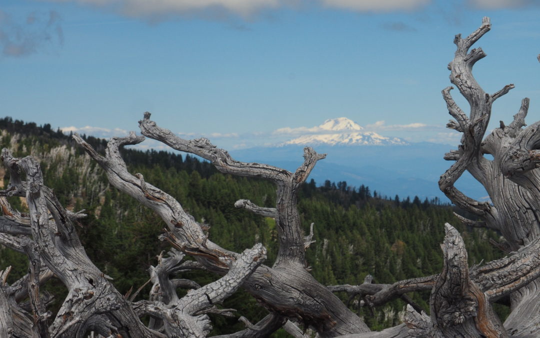
You can climb most of the way up Lamberson Butte on your left, to an elevation of 6,653. There are good places to sit and enjoy the panoramic views and the sounds of Newton Creek rushing through the valley below. On a clear day there are views to the south of Mt. Jefferson, Black Butte, the three sisters, and Broken Top, almost 90 miles away. Below you is where you’ll be following the Timberline Trail south. Mt. Adams is present in the east and as you gaze around towards the west you can see where the Gnarl Ridge fire burned in 2008.
On the way back down, enjoy the panoramic views into Eastern Oregon as Mt. Hood becomes obscured by the trees. You’ll find it is much easier hiking down the trail then up. The trail soon becomes less rocky and easier to navigate.
Bear right at the junction of the Gnarl Ridge Trail and the Timberline Trail and continue down the Timberline Trail. Be sure to look up from the trail to see Mt. Hood rising above you. In the distance you can hear the waters of Newton Creek.
The trail passes underneath a rocky outcrop as you continue walking towards Mt. Hood. As you approach Newton Creek, the trail climbs about 50 feet up to the streambed. From the floodplain you are treated to wildflowers and a great view of Mt. Hood.
Follow the rock cairns to the stream crossing and once across the stream look for the trail that leads out of the ravine. The trail picks back up on the far side of Newton Creek, a little downstream from where you cross Newton Creek. There are usually some logs to cross over Newton Creek but any high water will easily wash them away. Newton Creek is very dangerous to cross in times of high water.
From the crossing, the trail heads uphill past a lovely spring. The spring is just a couple of hundred feet away from Newton Creek. The water almost gushes out of the ground and is a great place to fill up on water without needing to filter the water.
Once across Newton Creek and past the spring the trail climbs up a couple switchbacks and meets the junction for the Newton Creek Trail #646. Go straight here, following the Timberline Trail.
Hug the mountain as you make your way through trees and meadows. Some of the ridges are full of lupine as far up the slope as you can see. In a couple of miles, round a spine of the mountain and enter Meadows ski area. Pass several streams and beautiful meadows both natural and man-made. Pass under quiet ski lifts and through flower meadows. Tree stumps aren’t too noticeable among the flowers.
Cross open meadows and small groves of trees as the trail crests and dips along the slopes of the mountain. Cross a service road and turn left on Umbrella Falls Trail. Walk downhill through an open forest with a little stream trickling down the mountainside just on your right. It isn’t long before the stream drops away from the trail and you pass through an area where the forest floor is covered in bear grass with a few lupine and other wildflowers mixed in. Soon you descend several switchbacks first through the forest then down a large mountain meadow filled with false hellebore, Sitka valerian, Mariposa lily, buttercups, and Lupine. The sound of a rushing stream greets you as you walk along.
Drop out of the meadow into some trees and cross a small stream. Climb a bit and drop down to a developed area, trapped in the pincers of progress between a road and a maintenance shed.
Cross the paved road, walking down about 150 feet and drop back onto the trail, skirt a pleasant meadow and gently ascend to the stream crossing just in front of Umbrella Falls. These lovely stair-stepped falls cascade about 50 feet making a cool breeze on hot days. There is a nice viewpoint just across the bridge and a log to sit where you can enjoy the falls.
Continue along the rises and falls of the Umbrella Falls trail, turning left at the junction with the Sahalie Falls Trail and ascend through more flower-filled mountain meadows and cross brooks tipping and falling into streams far below. Another little climb then steep descents through ski-run meadows filled with lupine with views down into Hood River Meadows.
Soon the forest trail leads back to the junction for Elk Meadows Trail where you turn right and walk the final .25 mile back to the trailhead.
Enjoy the photos!!
Gallery Pics
Switchback Steve
Recent Comments