

Vicinity Location:
The trailhead is 210 miles southeast of Seattle, WA and northeast of Portland, OR
Directions: Note that cell phone reception can be poor to non-existent all around this area. From Sprague, exit 245. Turn onto Highway 23, traveling south for 12.2 miles to Davis Rd. Turn right onto Davis Rd., at 4 miles there is a “Y”, stay to the right continuing south for 3 miles to Jordan Knott Rd. Turn left onto Jordan Knott Rd. and travel for 2.2 miles to the Rock Creek BLM public land access (.8 mile past Breeden Rd). Follow the BLM access road until it ends, 2.4 miles.
From the south: From Endicott W Road, Turn right onto Jordan-Knott Rd. at 6.5 miles bear left to stay on Jordan-Knott Rd. At 11.6 miles turn left onto unmarked road and go over a cattle guard. There is a sign for Rock Creek Management Area. Follow the BLM access road until it ends, 2.4 miles.
Trail:
No named trails
There is a geocache at: N 47° 03.561 W 117° 58.022 Info at Geocaching.com
Length and Elevation:
Total distance is 13.5 miles. Trailhead elevation is 1,457 feet. Highest point is 1,685 feet. Lowest point is 1,440 feet.
Total elevation change is 330 feet up and 330 feet down.
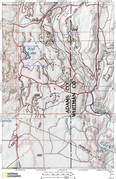
Trail Maps:
Topo Map, BLM Map, Download Garmin .gpx file
No permits are needed to park.
There is a bathroom at the trailhead.
History:
This area of the Cheney – Palouse Scabland Tract was part of the winter range for sheepherders and in the 1880’s this area had over 80,000 sheep on the winter range. My Great Great Grandfather, William Bircher was one of the men herding the sheep. He would be gone from home days at a time taking care of the flock. Out on the range he made biscuits by making a depression in the flour then dump the wet ingredients into the flour and mix it to make make the dough. In the spring the sheep generally gave birth in March, were sheared in May, then moved to the summer range in the Palouse Hills by driving the sheep along the roads. In the fall the sheep were herded back over the roads to the winter range.
The ranch was begun in the early 1900’s by Henry Traub as a sheep ranch and did will until the Great Depression. The ranch was purchased in the early 1940’s by John and Marcos Escure, brothers from the mountainous Basque regions of Spain and France. Basques are known for their sheepherding abilities and also migrated to the Bakersfield, CA area.
The Escure brothers expanded the ranch by purchasing more land and constructing new buildings. The ranch had a rodent problem and the only way to keep everything from being chewed and contaminated with droppings was to use concrete and steel. This ranch is unique because all the buildings have concrete floors and foundations and the walls and roofs are corrugated steel. The ranch produced fine merino wool until the price of wool collapsed in the mid 1950’s due falling demand after WWII and the invention of synthetic fibers.
Review: May 11, 2015
In the spring the sheep generally gave birth in March, were sheared in May, then moved to the summer range in the Palouse Hills by driving the sheep along the roads. In the fall the sheep were herded back over the roads to the winter range.
The ranch was begun in the early 1900’s by Henry Traub as a sheep ranch and did will until the Great Depression. The ranch was purchased in the early 1940’s by John and Marcos Escure, brothers from the mountainous Basque regions of Spain and France. Basques are known for their sheepherding abilities and also migrated to the Bakersfield, CA area.
The Escure brothers expanded the ranch by purchasing more land and constructing new buildings. The ranch had a rodent problem and the only way to keep everything from being chewed and contaminated with droppings was to use concrete and steel. This ranch is unique because all the buildings have concrete floors and foundations and the walls and roofs are corrugated steel. The ranch produced fine merino wool until the price of wool collapsed in the mid 1950’s due falling demand after WWII and the invention of synthetic fibers.
Head west over the bridge across Rock Creek and up to the ranch making sure to close the gates behind you. Make your way through the ranch, heading towards the track that goes up the hill. At the first junction, turn right and the trail will curve uphill to the right. Looking back there are nice views of the ranch and a panorama of the Rock Creek Valley.
The old farm road continues across the scablands and at 1.6 miles you approach a pair of gates. This land has cattle actively grazing so when you go through the gates, close them after you. Continue west along the farm road and enjoy the wide-open views of the basalt cliffs and and grassy meadows. In some places the soil is still too thin to support even grasses but other places have grasses and wildflowers sprinkled about in spring.
The farm road bends around to the north and after a bit you approach another gate to go through. From the gate it is about .1 mile to a junction to the right that heads down to Turtle Lake. Follow the path through the grass and you can see the lake off to the left, nestled between sun-worn basalt cliffs. The lake appears to be alkaline because there are some kind of salt crystals on the mud near the south shore of the lake.
Returning back to the farm road, continue through the open grasslands and soon the farm road parallels Wall Lake. Take a junction on a side trail that leads to a nice overlook of Wall Lake. Walk along a cow path above the lake for some nice views. Returning to the farm road, go another .1 mile to the trail junction to Wall Lake. Follow this track as it bends around to the northern end of Wall Lake.
Back on the farm road again, continue heading north and in a bit you will come to a 90 degree bend to the right at a junction. You can go north just a couple hundred feet and reach the John Wayne Trail which is a rails-to-trail route that is seldom used.
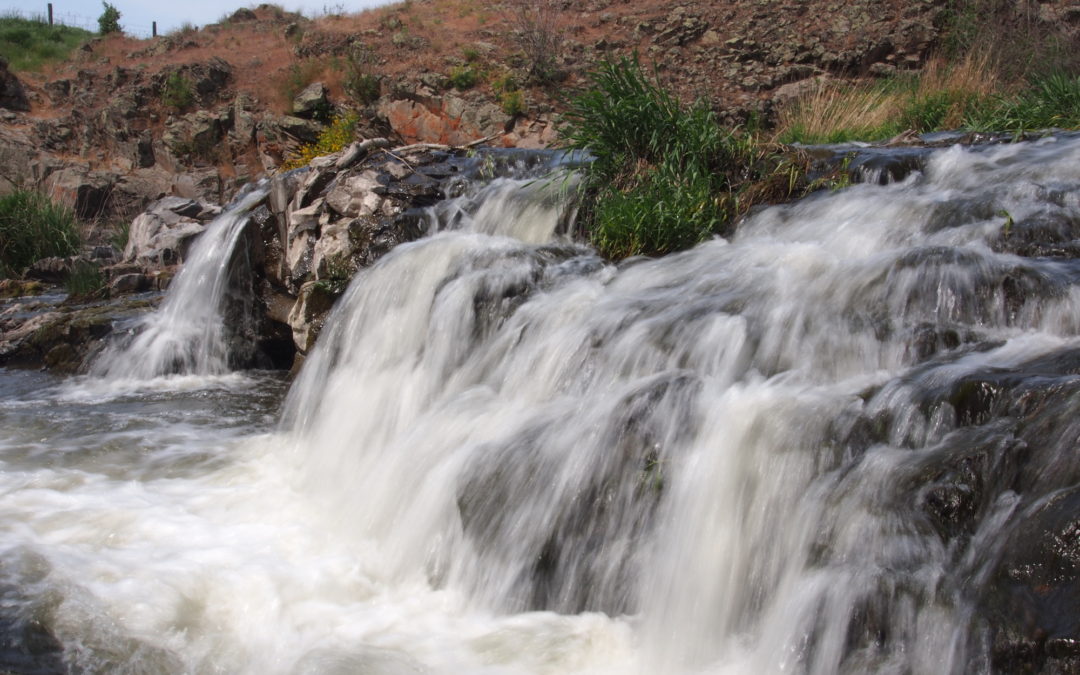
Go back to the junction and head east on Breeden Road and continue through thousands of acres of green grasses covering the open rangeland. Follow Breeden Road as it rolls across the countryside and drops down to Rock Creek. This is a very pleasant place to have lunch with plenty of places to sit with nice views. There is a small waterfall just above the bridge and you can make your way down to the falls and even soak your feet in small pools while enjoying a lunch or snack.
Just past the bridge is a small gate on the right. Leave the road and go through the gate and look for the trail which winds down and heads to the left over a small hill. From there you have to do some route finding, looking for the most used trail. Following the trail you will travel generally away from the creek and come to an overgrown farm road which will lead to a junction marked by a fence post. The left junction will lead up and above the creek, eventually joining the access road to the ranch. The right junction goes along the creek. In winter and early spring you will want to head up to the access road and walk it back to the parking area as the stream will be running high and cold.
Otherwise take the junction to the right and enjoy the path which stays fairly level and continues above the creek. There aren’t really any views of the creek from this part of the trail but you can down the green valley. The meadows are very pretty here because the valley is very green and there are large clusters of wildflowers along the creek. The basalt cliffs provide beautiful backdrops to the scenery.
The trail drops down to the creek where you ford the knee deep creek. After crossing Rock Creek, follow the farm road along the creek. Soon the farm road rises above the creek and passes through a meadow scattered with iris. The farm road goes through a gate then down the hill about 200 feet where you make a left and follow the farm road around the basalt cliffs. The farm road soon leads back to the corrals at the ranch.
This is a wonderful trip through scablands past lakes and a waterfall. There is and a stream crossing on the way back. It is a popular area for horse riding and there is a horse camp adjoining the parking area. There is also room for tent camping. Don’t expect to see many people because the area is uncrowded due to the rural character of the region.
This trail is not suitable for small children and dogs due to rattlesnakes in the area.
Enjoy the photos!!
Gallery Pics
Switchback Steve
Recent Comments