

Note: The roads leading to the Grassy Knoll Trailhead are typically gated and closed between December 1st and the end of May.
Vicinity Location:
The trailhead is about 75 miles northeast of Portland, Oregon in the Gifford Pinchot National Forest.
Directions:
To the PCT: Take I-84 east from Portland for about 40 miles and take exit #44 for Cascade Locks. Take the first right turn, just after you go under the Bridge of the Gods.
Cross the Bridge of the Gods with a $2 toll for cars. Across the bridge, turn right and drive east on WA Hwy 14. At MP 47.5 turn left onto Wind River Rd which leads north. (This is 3 miles east of Stevenson or 17 miles west of the Hood River Bridge).
Travel on Wind River Rd about .9 mile to a 4-way stop. Continue to go straight for 4.7 miles to the second sign for “Old State Road” on the right, also signed for Panther Creek campground. Turn right and then immediately left onto Panther Creek Road which turns into FR65. Follow FR65 for 4.7 miles.
Turn right onto FR68 and drive the narrow, bumpy road for 4.6 miles to a wide spot where the Pacific Crest Trail crosses FR68. You’ll know you have the right spot because you can see PCT trail markers on a tree trunk in either direction.
To Grassy Knoll Trailhead: From Carson, Washington take Wind River Highway to Bear Creek Road and turn right. Continue on Bear Creek to the Forest boundary where it becomes Forest Road 6808.
Stay on Forest Road 6808 to the junction with Forest Road 68 at Triangle Pass. Turn left on to Forest Road 68 and drive about 1.5 miles to Spur Road 511 and the trailhead which is at the junction in the road.
No permits to park are required at either trailhead.
There are no bathrooms at either trailhead
Length and Elevation:
Road Segment: 10.5 miles. Elevation gain 1,540 feet and loss of 1,495 feet.
Trail Segment: 10 miles. Elevation gain 2,600 feet and loss of 2,615 feet.
Trails:
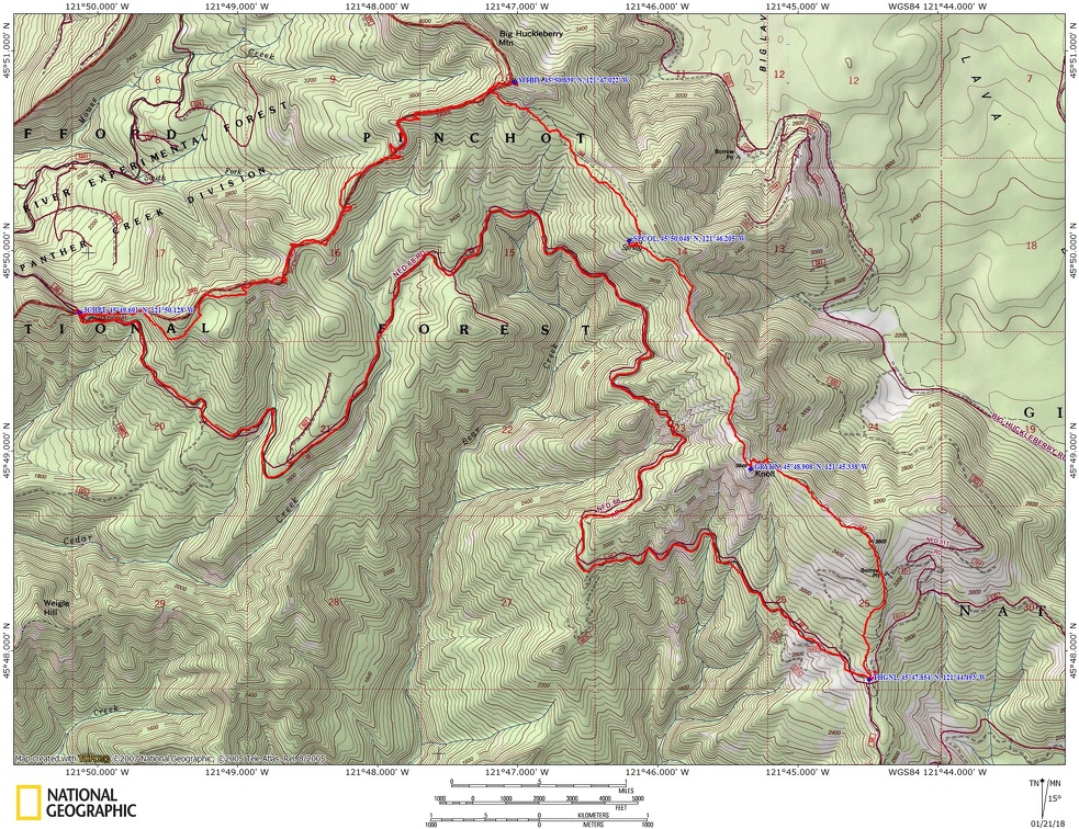
Grassy Knoll Trail #146, Big Huckleberry Trail #135, Pacific Crest Trail #2000.
There is at least one geocache for this trail at: N 45° 50.820 W 121° 47.024 Info at Geocaching.com.
Trail Maps:
Topo Map, Download Garmin .gpx file
Review: June 18, 2017
This was done as a bike and hike shuttle trip. We biked along Forest Road 68 from the PCT to the Grassy Knoll trailhead and stashed our bikes.
Bike south on FR65 for about 10.5 miles, first down a long, steady drop to a creek. From there it is a combination of steady climbs, level sections, and drops to the Grassy Knoll Trailhead. The two trailheads are at almost the same height but the road is not level.
At the Grassy Knoll trailhead you head north along the old route of the Pacific Crest Trail which started at Dog Mountain, gently climb from the parking area across a wildflower meadow into the forest. It doesn’t take long before the trail steepens and becomes a long slog up the hill. After about 1 mile walking up through the nice forest there are some views to the east of the Hood River area. Continuing a bit farther the trail sort of levels out and there are some nice viewpoints from the tops of some weathered basalt cliffs of the Big Lava bed and surrounding Mt. Adams.
From there the trail drops down a bit, following the ridgeline and passes through a pleasant forest with carpets of wildflowers and a couple of mountain meadows with wildflowers dotting the landscape. Some of the open areas had large anthills nearby. You’ll know if you are too close because these ants bite. I even had a couple latched on to the soles of my hiking shoes. Soon the trail climbs again and comes out to a very large alpine meadow full of wildflowers. This is the site of the former lookout where the Forest Service built a lookout on in 1934. You can find plenty of pieces of the former lookout while admiring the vistas.
From Grassy Knoll the trail stays under a canopy of trees and about 5 miles from the trailhead is a camping area and a short side trail down to Cold springs. Someone has called it the Alway Trail and does some maintenance. Down this trail there is a little bridge across the tiny creek from the springs and it is an excellent place to refill your water. The side trail goes on a bit farther then dies out.
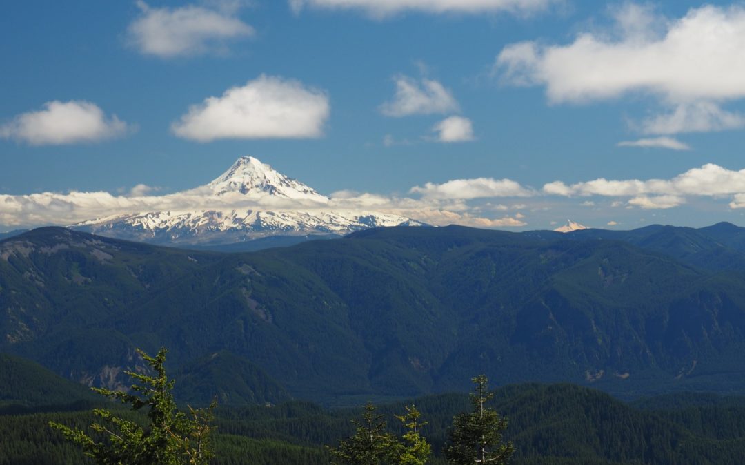
The trail climbs fairly steeply up to the junction with the PCT. From the junction of the PCT and Trail 146, take a short steep trail #135 up to the top of Big Huckleberry Mountain. There was a fire lookout built here in the 1920’s and was used through the 1930’s. There are pieces of glass and other remnants about but not as much as at Grassy Knoll. There is a large open area with nice views of Mt. Hood and some limited views of Mt. Adams through the trees. There are some additional meadows to the east where you get another glimpse of Mt. Hood.
Come back down on the side-trail and back to the junction of trail 146 and the PCT. Head west on the PCT, essentially continuing straight ahead from the Big Huckleberry Mountain trail. This part of the trail goes through a lovely forest and generally drops in elevation over a couple of miles. There are some gentle switchbacks that go down the side of a ridge, then some fairly level travel changing to a gentle descent along the side of the ridge. The forest here is lovely, old second growth Douglas fir trees with a carpeting of perennial wildflowers and other plants along the forest floor.
Continue along the graceful bends of the forested trail dropping down and then dropping down and then crossing a little saddle where you enter into the experimental forest. Gently climb along a ridge through the forest back towards the ending trailhead.
After climbing up along the ridge for about .5 mile the trail makes a switchback and if you continue straight ahead there is a short trail with a nice viewpoint of Mt. Hood, which is always nice to see on a sunny day.
Climbing up the ridge a bit further brings you to the top of a narrow little ridge and a really nice viewpoint of Mt. Hood and soon after that the trail drops steeply off the top of the ridge.
The trail stays in the forest the rest of the way to the PCT trailhead generally heading downhill with an ascent at the end. From there we drove down the very bumpy FR68 the way we had biked to the Grassy Knoll Trailhead where we had stashed our bikes.
This is a great trail for kids with some hiking experience. It is best to go when the wildflowers are blooming in July. There are some cliffs just off trail in the first couple of miles but only steep slopes after that.
Enjoy the photos!!
Gallery Pics
Switchback Steve
Recent Comments