

Vicinity Location:
About 55 miles east of Portland, OR in the Mt. Hood National Forest.
Directions:
From Portland, take I-84 east for about 55 miles and take exit 64 in Hood River for Hwy 35. Drive to the traffic signal and turn right onto Button Bridge Road/Hwy 35.
Drive south on Highway 35 towards Mt. Hood. After about 27.8 miles, look for the signpost for the trailhead on the left. If you cross over the East Fork of the Hood River in this area then you have gone too far. The trailhead parking is very small so you may need to cross the river for parking.
No permits are needed to park here.
There are no restrooms at the trailhead.
Length and Elevation:
Total distance is 13.9 miles. Elevation at the trailhead is 3,600 feet. Ascent 3,183 ft, descent 3,169 ft, maximum elevation 5,423 ft, minimum elevation 3,537 ft.
Trails:
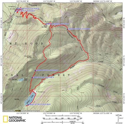
Gumjuwac Trail #480, Badger Creek Trail #479, Badger Lake Trail #479A, Divide Trail #458 with connections to Gunsight Butte Trail #685.
Trail Maps:
Topo Map, Download Garmin .gpx file, Open Garmin .gpx file
Review: July 3rd, 2022
Once you find the trail head immediately climb a couple of switchbacks through the woods along a nicely carpeted trail. Climb steadily through a dense forest of Douglas Fir and hemlock.
As you climb a multitude of switchbacks the forest opens up a little bit. You’ll pass the grove of cedar trees along the way then it is back to a mostly hemlock forest as you gain elevation. The trail up to the wilderness boundary is very well-maintained. At the time of this review all the deadfall had been cut out of the trail.
The Trail gains about 700 feet in the first mile then and continues to climb so that at 1.8 miles and you have gained about 1,400 feet where you reached the top of the ridge. There’s a nice rock formation here and then you go past a Scree field and start climbing much more gently.
After about 2.4 miles of climbing you pass a couple of springs just below the trail then at 2.5 miles you reach a forest road and a junction where you go straight across the road and head downhill. Your return trail forks off to the right.
After going about 50 feet you’ll see the trail sign for the Gumuwac trail #480.
Heading downhill cross the headwaters of a stream and then after a couple switchbacks cross the stream again, this time larger but still just a step across stream, soon followed by another step across stream. This is about the end of the trail maintenance will you start encountering a brushy trail and blow down.
Continue downhill and there’s a nice spot for lunch just after crossing Gumjuwac Creek.
Continuing downhill you’ll pass through some mountainside clearings and lush forests. In about 4 miles cross another lovely little step-across stream. So far there have been plenty of places where you could get water for your trip.
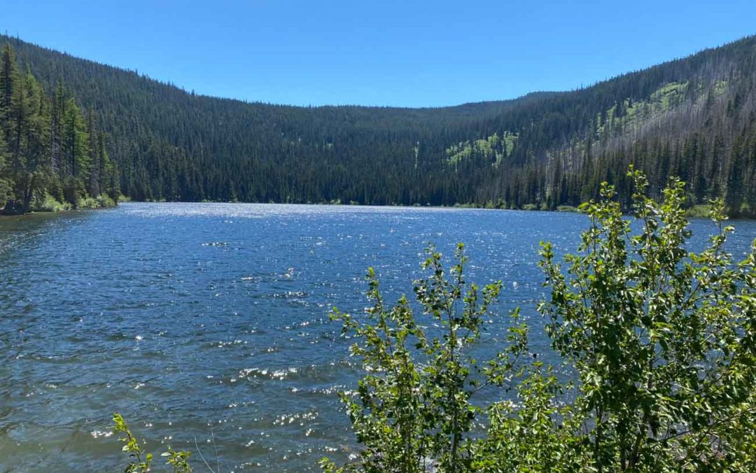
After about 4.7 miles you come to the junction of Badger Creek Trail #479. Turn right here and cross over Badger Creek. There are a couple of small campsites here.
From this junction it is a gentle 2 mile climb through a pleasant forest to the lake. There is an interesting mix of trees along this trail with Ponderosa pine, grand fir, Hemlock, Douglas Fir, and silver fir.
Dropping down to the lake you pass your return route, the Divide trail. At the lake there is an unmaintained trail that goes around the lake however it was impossible to navigate all the way around the lake for this hike due to downed trees and heavy brush.
For the return leg go back up the trail you came into the lake on and after about two or 300 feet make a left and then soon you’ll make a right.
Take the Divide Trail which climbs steeply up Ridge. There’s a couple of places where you can get good water in the first quarter mile or so. Climb steadily passing an occasional stream and views of the surrounding ridges. Eventually meet back at the signed junction with the Gumjuwac Trail then follow the forested switchbacks down to the trailhead.
Enjoy the photos!!
Gallery Pics
Switchback Steve
Recent Comments