

Vicinity Location:
The trailhead is about 32.5 miles northeast of Portland, OR on the north shore of the Columbia River in the Gifford Pinchot National Forest.
Directions:
From Portland take I-205 North; drive past the Portland Airport Exit and cross the Columbia River. Move over to the right lane as you cross the bridge. Take exit 27 for Vancouver/Camas and move into the left lane on the off ramp heading towards Camas. Follow SR-14 to Beacon Rock State Park which is just before Milepost 35. Kueffler Road comes up just before the Park Headquarters of Beacon Rock State Park. This is a Y-Intersection and if you miss Kueffler Road, you can turn left about 50 feet after the Kueffler Road street sign.
To reach the Kueffler Road trailhead, follow the winding paved road uphill about 1 mile and make a right turn onto the gravel road to the equestrian trailhead. Follow the gravel road about .4 mile to a large gravel parking area. The trail is at the east end of the parking area just past the gate.
There are bathrooms at the parking lot.
Park hours are 8am to dusk and there is a gate that could be locked at night.
A State of Washington Discover Pass is required for parking.
Length and Elevation:
8.3 miles roundtrip. Elevation gain 2,100 feet and loss of 100 feet to the turn-around point. Total gain and loss is 4,400 feet. Elevation at the trailhead is 770 feet, the summit elevation is 2,770 feet. Hike can be extended .3 miles to elevation 2,957.
Trail:
Hardy Ridge Trail with connections to Hamilton Mountain Trail.
There are no geocaches along this trail at the time of the review.
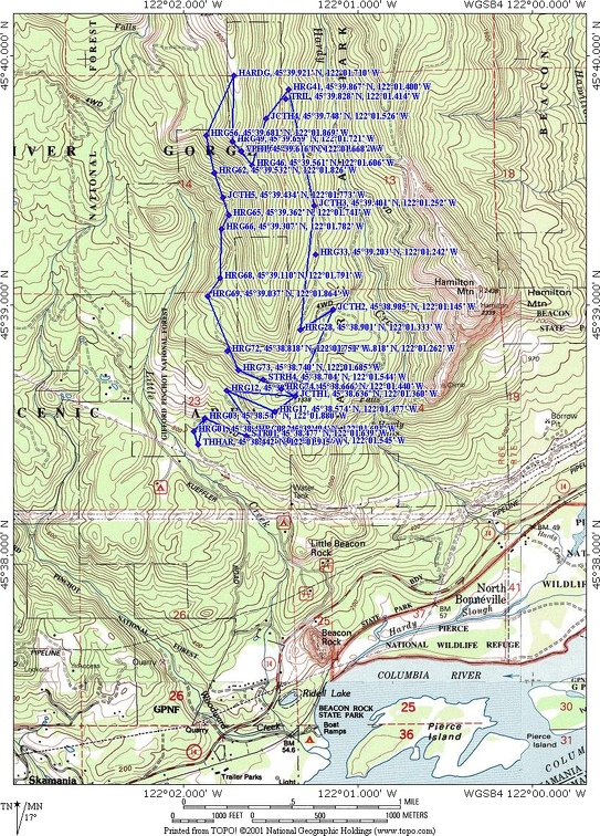
Trail Map:
Topo Map, Download Garmin .gpx file
Review: July 7, 2010
The trail uses an old gravel road for about the first mile. About .3 mile from the trailhead is an old slide area that has been repaired and just after the slide area is a small mountain stream that flows underneath the road through a culvert. The dirt road continues winding uphill and at .6 mile from the trailhead the road crosses the stream again. The trees along this part of the trail are mainly Douglas Fir mixed with alders and maples.
The understory growth along the lower section of the trail has Vine Maple and Filberts, along with ferns and grasses. About 1.2 miles from the trailhead is a 4-way junction. The trail to the left is the west portion of this loop trail.
Continue straight ahead at this 4-way junction. The Hardy Ridge Loop trail goes uphill. At 1.7 miles is another 4-way junction where the lower loop trail comes into the main trail and the Hardy Ridge Loop Trail branches off to the left. Follow this trail to the left. The dirt road now climbs up a single switchback then is fairly level and even descends a bit for the next .25 mile.
The trail continues through the forest, following the old dirt road. When you come to the next junction, continue uphill on the dirt road along Hardy Ridge. 3 miles from the trailhead the road ends and you continue uphill on a dirt trail, continuing through a forest of Hemlock and Alder trees. Just after the beginning of the dirt footpath is a trail junction to the left that is almost hidden from view. This is a short alternate trail that can be used, but it is a bit more steep than the mail trail.
The narrow dirt trail climbs fairly steeply up the ridge, switchbacking up the hill. One small section of this trail is just roughed in, awaiting finishing later this year.
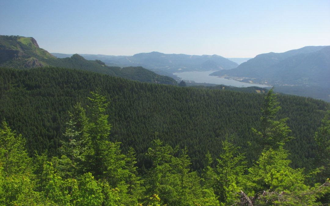
At 3.23 miles from the trailhead is the upper junction for the alternate trail. Continue heading uphill and at 3.6 miles there is a small way trail off to the left leading to a viewpoint with nice views of Mt. Hood and the Columbia River Gorge. This is also the junction for the Hardy Ridge connector trail which you take on the way back and is marked on the map as JCTH6 at N45° 39.622’, W 122° 01.671’.
From the junction, the trail climbs up through a large meadow filled with wildflowers in late June and July. There are great views of Mt. Hood and the entire Columbia River Gorge. The trail soon enters the trees and the trail becomes very brushy. Continue along the lightly used trail which undulates along the ridge and pick your turnaround spot.
Returning back along the ridge trail, turn right at the Hardy Ridge Connector Trail. The trail drops down off the side of the ridge using several switchbacks. There are a couple more views of Mt. Hood before Hardy Ridge blocks views to the south.
The trail drops steeply down Hardy Ridge on a gravelly trail. The trees obscure most of the views to the west and the brush can be drenching on wet days. After descending down several switchbacks, the trail intersects an old logging road. Turn left here and continue downhill on the winding road which is quickly changing into a single footpath. The west side of Hardy Ridge has less shade than the east side until you get back to the junction of East and West Hardy trails.
After following the old road for about 1.2 miles, you reach the 4-way junction leading back to the trailhead. Turn right and from the 4-way junction, follow the road back down to the parking lot.
Enjoy the photos!
Gallery Pics
Switchback Steve
Recent Comments