
Notice: 9/24/2019 This trail is now open but expect hazards due to the 2017 Eagle Creek fire. Watch for fire-weakened trees, rockslides, landslides, stumpholes, and washouts. Avoid this trail during high winds and heavy rains.
Directions:
From Portland, Oregon, take I-84 east for about 40 miles and take exit #44 for Cascade Locks. Drive through town, heading east. Look for the sign with the symbol for the airport. Turn left across from Edgewood Avenue and drive 2 miles, cross over I-84 and turn left at the road junction. Go about .3 miles and make a right turn onto the campground access road. The road narrows and goes uphill to the campground and trailhead. Follow the hiker signs through the campground to the hiker’s trailhead. Turn right, off the paved road, and arrive at the trailhead. This is one of the few trailheads that has a water supply.
Length and Elevation:
15 Miles round trip Elevation gain 4,500 feet and loss of 50 feet. Total gain and loss is 9,100 feet. Elevation at the trailhead is 50 feet, Nick Eaton Ridge elevation is 4,000 feet.
Trail:
Herman Creek Trail #406 with connections to #400, #406A, #406B, #406E, #406G, #408, #410, #447, and #476.
An outhouse is available at the parking lot. There is a drinking fountain and spigot just before the trailhead.
A Northwest Forest Park permit is required to park at the trailhead.
Trail Maps:
Topo Map, National Forest Service Map
Review: May 7, 2007, July 24, 2008
The trail gets your attention as it immediately goes up several switchbacks. The hillside has several water seeps in the springtime but they dry up in the summer. The trail comes up to a set of powerlines. Turn right under the powerlines and continue uphill. The trail parallels under the powerlines for a short distance before turning to the left, uphill. The trail reenters the forest and passes through a boulder field. The first trail junction sign points to Herman Ridge Trail to the right, Herman Creek Trail to the left, and Herman Creek Camp .7 miles away. Take the left junction going uphill.
Just before the trail is about to come out into a little clearing, is a junction to the right for an unmaintained trail. Skip that junction and walk through the clearing and take the trail on the right which goes uphill. Just before the edge of the clearing, you will see a sign on a tree for Herman Creek Trail #406. The sign points both the way you came from and the way you are about to go. I’ve marked the point JCTHD at 45 40.786′ N, 121 50.407′ W.
Continue uphill for about 1/2 mile to the next junction. It is time to get your compass out to find the direction to the correct trail. This 4-way junction is marked JCTHN at 45 40.808′ N, 121 40.739′ W. You should take the trail that bears 50 degrees from true north which keeps you on trail #406. If you go to the left, you’ll be on the Gorge trail #400 to Wyeth. Taking the right fork continues on Herman Creek Trail.
If you would like to get water, then you can take a short side trip. About 30 feet before junction JCTHN is a faint track that bears about 220 degrees from true north. Follow this downhill for about .1 miles and you will hear the sounds of a small spring. Let the noise of the spring guide you the rest of the way. The spring is a metal pipe coming horizontally out of the ground splashing into a small pool. It is easy to fill up water bottles.
In a short time is another junction. The sign at the this junction says Gorton Creek Trail #408, and also it leads towards the Ridge Cutoff Trail in 2.6 miles. Take the left trail, #408.
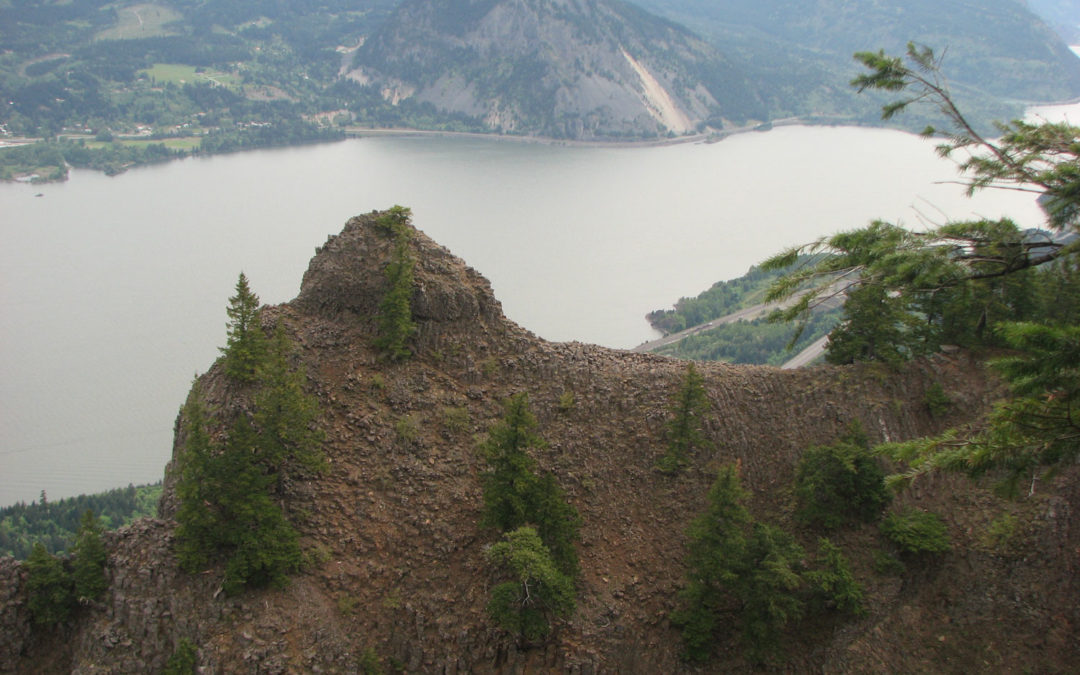
When the trail ascends the slope in several switchbacks, take the time to look down and notice several different kinds of mosses that are growing along the trail. You are far from the car traffic noise but you will hear the wails of the trains as they pass through the gorge. Just a couple of switchbacks past Indian Point, you’ll come to a different trail junction. You can take the Ridge Cutoff Trail or head towards the Deadwood Trail on the Gorton Creek Trail. Indian Point looks like it was a lava dike of basalt that has weathered away leaving a big rounded point of rock poking into the sky.
At the next junction, continue straight ahead. The trail drops slightly downhill. Just past the trail junction is another little trail junction that goes downhill. Follow this slippery and steep trail down to the spine of Indian Point. The trails ends in a reasonable sized clearing. If you’re daring, you can go further out on the rock spine. Good views of Table Mountain, the Gorge, and the community of Stevenson, Washington can be appreciated depending upon the cloud cover. To the west is a great view of a columnar basalt cliff. If you go out on the spine of the rock, there is a great view of Mt. Adams to the north. Retrace your steps back to the junction. From here you have several loop options. This review turns left and continue left on trail #408.
If you want to hike a little used trail, continue on Trail #408 past Deadwood Creek camp. There is a spring near the camp where you can get water. After the camp, the brush is taking over the trail and there are several deadfalls that haven’t been logged out. The trail is fairly pleasant as the trail goes through the woods. The trail climbs a ridge, switchbacking at times, you will cross a rockfield that has a great view of Mt. Adams and the Columbia Gorge. The trail passes over one of the headwaters of Gorton Creek. In the springtime you can hear the water running underneath the rockfield and you may even be able to spot the stream in a place or two if you look carefully. I think it is an interesting phenomenon when you can hear the water running under the rocks, but you can’t see it.
A few more switchbacks and you’ll arrive at the Mark Hatfield Wilderness boundary. I saw some tracks in the snow and it looked like there was only two people on the trail Saturday. This boundary point does not have any permit forms available. Use caution in the spring because the trail will be hard to find with any snow cover because of all the branches littering the trail. Watch carefully for the junction to Herman Creek Trail. It is in some brush and you might well walk by the junction. The trail junction is off sharply to the right and it goes uphill a little. This next section of the trail is not suitable for trail running because of the boulders in the trail and the branches sticking out into the trail. JCTHR is the waypoint that marks this junction on the map. The trail here is not much more than a trace so follow it carefully through the Oregon Grape and Beargrass. The trail goes uphill a bit, crosses the ridge and starts descending.
This portion of the trail is fairly level along the ridge. There are places where there are boulders in the trail that can be slippery. The trail follows along the ridge and then drops sharply off to the west. There are a few views of the gorge through the trees. You would think that there would be less trees and better views because of all the rocky slopes.
The trail continues steeply down the slope through the woods. There is a small open meadow with views of the surrounding mountainsides. The trail shortly enters the woods again and switchbacks down towards the valley. There is a place in the trail where some very large trees have covered up the switchbacks. You have to pick your way among these monsters and pick up the trail again. With trail maintenance budgets slashed, it will be some time before someone will come along and get these big monsters out of the way.
On the map, JCTCP is the junction of Casey Creek Trail and Herman Creek or Nick Eaton Trail. A sign points upriver to Cedar Swamp Camp. At the junction with the Herman Creek trail, you will turn right and there is a camp with a .3 mile trail down to Herman Creek to get water. Heading downstream towards the trailhead, you will pass a nice springtime wildflower rock garden. A little later is a very nice little waterfall. You will cross a bigger stream and a bit further down the trail is a waterfall about 120 feet tall.
The waterfall must be a fairly popular destination because the trail becomes much wider after the waterfall. The trail undulates towards the trail head in the woods. Past the junction to trail #447, on your right, rejoin with your original trail to the trailhead.
Most of this trail is in the forest with only limited views of the Gorge and surrounding mountains. Save this trail for a spring or fall hike on a cloudy day. You will find plenty of switchbacks on this trail.
Enjoy the photos!!
Gallery Pics
Switchback Steve
Recent Comments