
Notice: 7/5/2023 – This trail is once again closed due to a previous forest fire.
Notice: 7/15/2022 – The Siouxon Creek trailhead is now 2 miles west and adds 4 miles to this hike. Much of this trail is in a burned area and should not be hiked in times of heavy rain or high wind. Watch for hazard trees falling unexpectedly.
Vicinity Location: The trailhead is about 38 miles northeast of Portland, Oregon in the Gifford Pinchot National Forest.
Directions:
From Battle Ground, WA, take Hwy 503 North to Chelatchie Prairie. Turn East (right) at the Chelatchie Prairie General Store and gas station, onto NE Healy road. The store is on the northeast corner of Hwy 503 and NE Healy road. NE Healy road changes into Forest Road 54 after a few miles.
Follow this route for about 9 miles from the general store. Look for the “pavement ends sign” and turn left, uphill, on FR 57.
After another mile turn left again onto Rd. 5701. The road may be unsigned but it is the junction just past a quarry on the left. Follow this mostly paved road to the trailhead in a little more than 4.9 miles from the junction with FR 57.
Even though the high point on the road is less than 2000 feet in elevation, late winter snow can block this road. This is because after it crosses a ridge, the road is in the shade as it drops down to the trailhead.
Call the Gifford Pinchot National Forest for current information at (360) 891-5000 or visit the Gifford Pinchot Recreation webpage for the road and snopark information.
There are no restrooms at the trailhead. The nearest bathrooms are at the Mt. St. Helens Monument Headquarters in Chelatchie Prairie (Amboy).
Note: No permits are required to park at the trailhead.
Trail:
GPNF Trail 130 and 140.
There is a geocache along trail 130 at: N 45° 57.645 W 122° 08.309 Info at Geocaching.com
Trail Maps:
Topo Map, Download Garmin .gpx file
Length and Elevation:
10.5 Miles Roundtrip for the loop. Elevation gain totals 3,500 feet. Total gain and loss is 7,000 feet. Highest elevation is 3,345 feet.
Review: October 13, 2012.
From the main trailhead at Siouxon Creek, follow the trail gently downhill to the left for about 100 feet to a junction for the Siouxon Creek trail. As of this review, the trail sign has been shot several times. Turn right at the junction and continue gently downhill. Soon the sounds of a tributary to Siouxon Creek can be heard. The wide, well maintained trail leads to a log bridge over the small creek after about .1 mile. The water of the stream is crystal clear and flows about 10 feet below the single-log bridge.
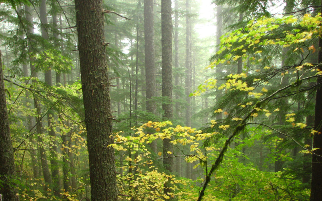
Soon the trail passes a camping area that is used heavily during the summer by car campers. The trail goes along the creek, through an open second-growth forest. The understory here is mainly ferns and apple clover.
At a junction in about .75 mile, a small trail parallels Siouxon Creek trail for about .2 mile, passes a small campsite, and ends at the junction for the Horseshoe ridge trail.
Turn right and you’ll know you are on the correct trail because as soon as you start, the trail begins climbing steeply away from Siouxon Creek. The first part of the trail is well maintained. Several work parties have cleared deadfalls off the trail during the last few years.
The trail bolts up the hill, like a lightning bolt with short, jagged switchbacks which almost seem vertical. After trudging upwards for more than an hour, you get a short break in the climb as you reach a shoulder on the ridge, but you’re not nearly done with the ascent.
The trail veers to the left and keeps climbing up the ridge, though not quite as steeply as on the lower section. Now at about 4,000 feet, there are a few huckleberries, Oregon grape, salal, and mosses, but not much else. The canopy of the hemlock and the elevation have combined to choke out most of the undergrowth.
After a moderate amount of elevation gain, the trail yet again hits another very steep climb. This hike is a strong workout for your calves, stretching them tight with every step.
After walking about 1.8 miles, the trail passes a rocky promontory that has some views on a clear day. Eventually the trail breaks out to a vista looking south, then continues along the spine of the sawthtooth ridge without the aid of switchbacks.
2 miles from the trailhead, the trail begins to level out but still has some short steep sections and even some short descents. Travel below the ridgeline for a bit, avoiding some of the knobby, worn-down teeth of Horseshoe Ridge. All too soon the trail climbs and crests the ridge again, continuing northwest.
At 2.4 miles, walk past kinnikinnick and a carpet of juniper as you got through a couple of tiny mountainside meadow which have some views to the northeast.
The trail here is not as steep but still climbs gently towards the high point the trail, 2.5 miles from the trailhead at 3,345 feet in elevation. In another .5 mile, cross two more meadows with kinnikinnick, juniper, and short grasses, with views to the northeast. Pay attention along this section because even a small layer of snow on the ground will cover any traces of the sketchy trail in the second meadow. If you are looking for where the trail reenters the woods, look level, or just slightly uphill.
Fog and mist enveloped me as I re-entered the forest and the dank forest felt ominous with trees leaning over the trail with dead branches dangling down about head and shoulder level, like they’re waiting to grab you as you walk through the dim forest. Other trees crouch near the ground, waiting for their chance to trip you, as you try to avoid the grasping branches. Dark ominous roots have crept into the trail from deep in the ground, waiting for their chance to seize your boot as you hurry by in the ever increasing gloominess.
Other branches scrape across your neck as you begin to worry if anyone would ever find you if something happened to you on this spooky trail. Other branches bar you way, hoping to draw a drop of blood as you push by, seeking to find the end of this gloom.
After escaping the clutches of the eerie forest, one last trick has been played. The trail builders built in another 100 feet of gain before beginning a gradual descent.
After dropping down for a bit, pass by a hunting camp, climb a bit, then drop down to an old road. Turn left at the road and walk about 100 feet to where the trail goes back into the woods.
At first the trail descends gradually, crossing a steep slope on a very narrow tread. After about a mile, the trail drops sharply down towards Siouxon Creek. After about .6 mile of sharp descent, the way gets easier and the tread becomes wider. Switchback down to the Siouxon Creek Trail and turn left, heading back towards the trailhead.
Walk a little more than 2 miles, passing Siouxon Creek Falls and Horseshoe Creek Falls, watching out for mountain bikers.
This is a difficult trail with the rapid elevation gain, the many deadfalls that seem to plague this trail, and the sections of narrow tread. This is a great trail for a good workout or conditioning hike. You could go for a dip in the cold Siouxon Creek if hiking this on a hot day.
Happy Halloween
Enjoy the photos!!
Gallery Pics
Switchback Steve
Recent Comments