
Notice: 7/5/2023 – This trail is once again closed due to a previous forest fire.
Notice: 8/14/2021 – Because of the Big Hollow fire the traditional trailhead is closed. The Siouxon Creek trailhead is now 2 miles west and adds 4 miles to this hike. Much of this trail is in a burned area and should not be hiked in times of heavy rain or high wind. Watch for hazard trees falling unexpectedly.
Vicinity Location:
The trailhead is about 37.5 miles Northeast of Portland, OR in the Gifford Pinchot National Forest.
Directions:
From Battle Ground, WA, take Hwy 503 North to Chelatchie Prairie. Turn East (right) at the Chelatchie Prairie General Store and gas station, onto NE Healy road. The store is on the northeast corner of Hwy 503 and NE Healy road. NE Healy road changes into Forest Road 54 after a few miles.
Follow this route for about 9.4 miles from the general store. Look for the “pavement ends sign” and turn left, uphill, on FR 57.
After another mile turn left again onto Rd. 5701. This junction is just past a quarry on the left. Follow this mostly paved road to the trailhead in a little more than 4.9 miles from the junction with FR 57.
Even though the high point on the road is less than 2000 feet in elevation, late winter snow can block this road. This is because after it crosses a ridge, the road is in the shade as it drops down to the trailhead.
There are no restrooms at the trailhead. The nearest bathrooms are at the Mt. St. Helens Monument Headquarters in Chelatchie Prairie (Amboy).
Call the Gifford Pinchot National Forest for current information at (360) 891-5000 or visit the Gifford Pinchot Recreation webpage for the road and snopark information.
Note: No permits are required to park at the trailhead.
Bring some wading shoes for the creek crossing.
Trail:
GPNF Huffman Peak Trail 129, Wildcat Falls Trail 156, Chinook Falls Trail 130A with connections to Trail 140.
There is a geocache along trail 130 at: N 45° 56.908 W 122° 10.458 Info at Geocaching.com
Trail Maps:
Topo Map
Length and Elevation:
19.4 miles round trip. Elevation gain of 3,350 feet and loss of 650 feet to the summit of Huffman Peak. Total gain is 4,340 and loss is 4,340 feet round trip. Elevation at the trailhead at 1,340 feet, highest point is at 4,060 feet. Lowest elevation is 995 feet.
Review: October 22, 2008.
As you’re driving east on NE Healy road you may wonder what that cone shaped peak in the distance is. It is Tumtum Mountain and it rises 1,400 feet from Chelatchie Prairie.
Park at the trailhead at the end of the road and find the trailhead, which is in the middle of the parking area, on the north side of the parking area.
Walk down the trail about 100 feet and make the first left. In about 200 feet there is another junction. The trail to the left leads back up to the road and the trail to the right is the trail you want which leads to the Huffman Peak Trail.
Walk about 2 miles along the winding trail through the woods. Along the way, you’ll pass several small streams which are easy to step across. The junction to Huffman Peak Trail, #129 is easy to spot. The trail drops down towards the creek while the left junction goes uphill. Follow the trail down several short switchbacks down to a flat area that leads to the creek.
You have to wade across the creek and the rocks can be slippery. The creek flows fairly fast and the rocks are about cantaloupe sized and larger, which makes a barefoot crossing inadvisable. There is no way you can rock-hop this stream crossing. Look just a tiny bit upstream for where the trail goes up the far bank of the creek and into the woods.
The undergrowth along this part of the trail is mostly sword fern and oxalis, but as you drop down towards the river the undergrowth changes more to sword ferns and salmon berries.
The trail climbs steeply for about the first mile after the creek crossing and goes up several switchbacks. The next mile or so is a section where the trail levels off and drops down a little bit through the second-growth forest. There isn’t a lot of brush in this section because of the heavy tree canopy. Most of the undergrowth here is Oregon Grape and Bracken Fern.
The trail climbs again and the trees become sparser for a while. The trail goes along the edge of a cliff with some views to the south and west, then back into the forest and climbing fairly steeply up a ridge for about a mile. The undergrowth along this section of the trail is mostly Vine Maple and huckleberries.
About 4.5 miles from the stream crossing you com to the junction to North Fork Siouxon Trail #126. Decide if you want to scramble up to Huffman Peak from this junction for the views spectacular views from Huffman Peak.
If you plan to climb Huffman Peak, look for a campsite to the right of the trail and the user trail heads east from the camp. Also as you’re going up the user trail to the Huffman Peak, be aware there are dead branches about forehead level that are waiting to poke you in the eye.
The user trail in the forest is easy to see but it begins to die out as you start to climb the slope through the bear grass and fir trees. It is hard to say which is the best way to scramble up through the gaps in the trees. Heading a little to the right and staying towards the south side of the ridge is probably the easiest way to the top. Once you scramble the .5 mile and reach the summit, there are great views of Siouxon Valley and Mt. Hood to the south and Mt. St. Helens and Mt. Adams to the north.
Plan to come back down the same way you went up because the north slopes of Huffman Peak are very steep and there are some cliffs. If you try to shortcut down to the trail, you may have to work you way around cliffs and it would be no shortcut at all.
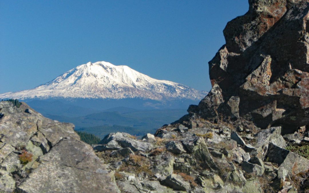
Back at the Trail, turn right and continue eastwards from the junction. The trail climbs a little bit and after about .5 mile, turns a corner and goes along the north side of Huffman Peak. The trail crosses a rocky scree slope which provides nice views of Mt. St. Helens and Mt. Adams.
The trail goes along the south side of the ridge, crosses a saddle, then traverses the north side of a ridge from Huffman Peak. After a bit the trail starts dropping down and gets closer to being back on top of the ridge. Just before that happens, there is a small trail that goes fairly steeply back uphill along the ridge, sharply to the right. This is the trail you want, Wildcat Trail #156. If you miss this junction, you will come to another saddle and start a gentle climb towards Siouxon Peak.
Wildcat Trail #156 climbs southwest up the ridge and after about 500 feet, tops a small knoll and turns left. Perhaps there was a view from the knoll in the past but the trees obscure any views now. After going over the top of the knoll the trail descends gently towards the southeast. This part of the trail is a little indistinct so be careful not to lose the trail. If you get off the trail a little, just stay on the top of the ridge and you’ll pick up the trail again.
A little over a mile from the knoll, the trail goes down a whole lot of switchbacks and finally comes out to a clearing overlooking Wildcat falls. The overlook is at the top of a cliff that goes down a few hundred feet to the base of the falls. It is a fine view here of the falls plunging over a cliff into the chasm below.
The bottom of the switchbacks comes out near the base of the Wildcat Falls, which cascades 75 feet to a pool at the base of the falls. The trail follows Wildcat creek for a couple hundred feet to a trail junction. The right leads down to a ford of Siouxon Creek and Wildcat Trail #156 continues on the left. After about 200 feet on the main trail, you come to Wildcat Creek. You will want to go downstream a bit and cross on the rocks in the creek. The logs here are slippery and using them to cross is dangerous. After that, the trail follows along Siouxon Creek and climbs above the creek on the way to Chinook Falls. This upper part of Siouxon Creek is a rainforest with sphagnum moss hanging off all the Vine Maples and fallen logs. You can see this area is very wet through much of the year.
After about .5 mile you reach a junction for trail 130A and you turn right and head towards Chinook Falls. Chinook Falls is about 50 feet high and you can walk almost to the base of the falls.
The best crossing for Chinook Creek is slightly downstream of Chinook Falls. There is a log across the creek that is used as a handrail while rock-hopping across the creek. Using this method, you avoid walking on top of a log and the chance of falling onto the rocks in the creek.
From there, the trail goes along Chinook Creek past a couple of camping areas and crosses Siouxon Creek on a log bridge. The trail generally follows Siouxon Creek back to the trailhead. There are beautiful green pools and some waterfalls to enjoy on your way back to the trailhead. The trail here is very well maintained and popular with mountain bikers so be prepared to give way to them on weekends.
The trail is wide, fairly level without too many ups and downs but descends gently towards the trailhead. It is a very pleasant walk listening to the sounds of the creek as you make your way back to your car.
About 1.5 miles after crossing Chinook Creek is a 30 foot waterfall on Siouxon Creek with a bench nearby where you can sit and enjoy the sights and sounds of the waterfall. In about 1000 feet farther down the trail is a junction for a side trail that is about .3 mile long. This side trail leads down past campsites to a viewpoint of a waterfall on a small stream.
About .2 mile after the junction for the side trail, Siouxon Creek Trail #130 crosses Horseshoe Creek just above the waterfall on a metal girder bridge with a wood deck. The trail continues through the woods for about a mile to another bridge. This bridge crosses West Creek about 10 feet above the creek.
The last part of this trail is about a 100 foot climb back up to the parking lot.
This is good workout with a stream crossing and bushwhacking thrown in for variety. The trail to Huffman Peak and Chinook Creek is not suitable for small children due to the stream crossing and cliffs along the trail. Be aware that unleashed dogs could fall off the cliffs between Huffman Peak and Chinook Creek. In 2008 there were a lot of deadfalls on the trail that have to be negotiated by stepping over or maneuvering around.
Enjoy the Photos!
Gallery Pics
Switchback Steve
Recent Comments