

Notice: 6/17/2023 – This trail is now open. SR504 – Spirit Lake Memorial Highway remains closed to all travelers at milepost 43 near the Science and Learning Center.
Vicinity Location:
The trailhead is about 42 miles north of Portland, Oregon in the Mt. St. Helens National Monument.
Directions:
From Portland take I-5 North to exit 49 for Castle Rock. Turn right towards Mt. St. Helens and drive about 47 miles on Highway 504. Turn right into the parking area for the Hummocks Trail.
No restrooms at the trailhead. The nearest restrooms are across the road at Coldwater Lake.
No dogs are allowed in large portions of the monument, including this trail.
You can see avalanche forecasts here: Northwest Avalanche Center
National Weather Service Snow Level forecast: South Washington Cascades
Length and Elevation:
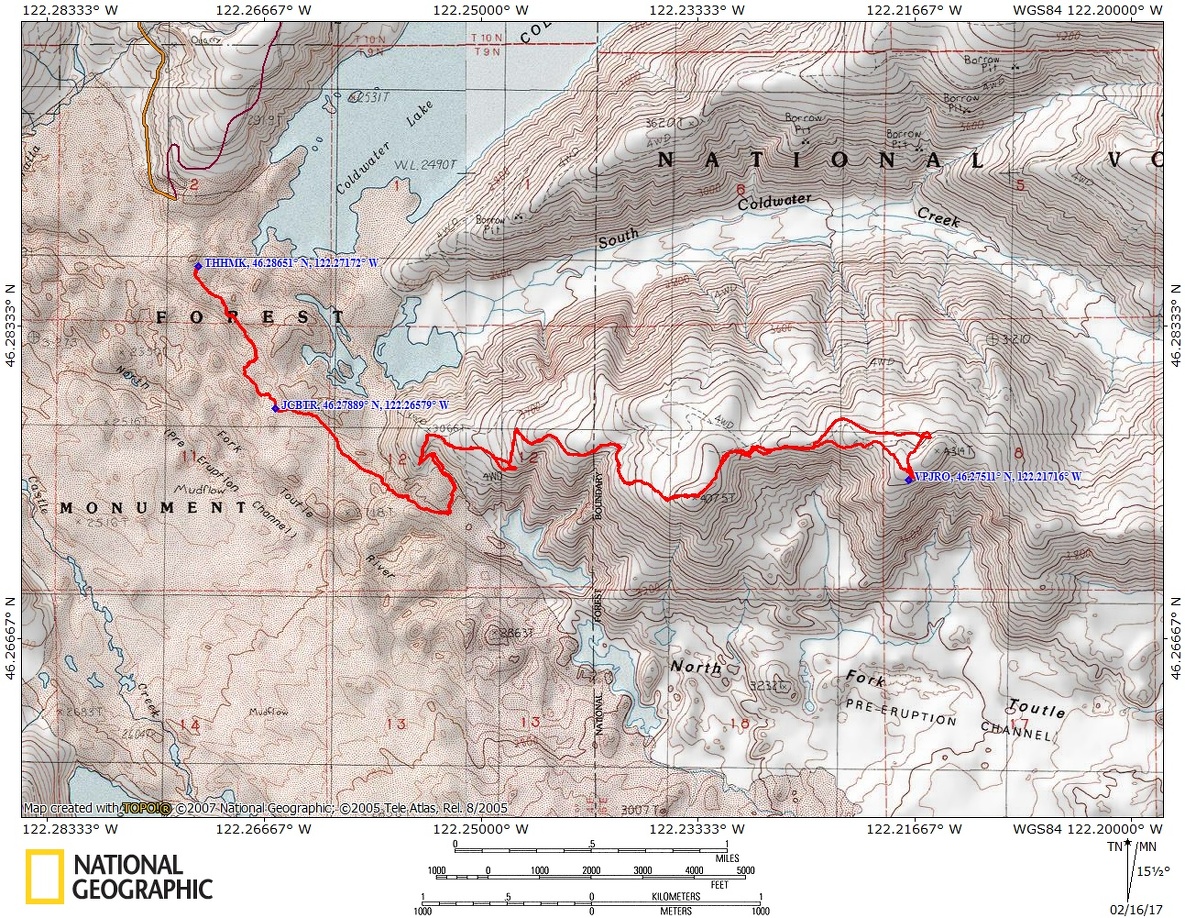
9.5 miles roundtrip. Trailhead elevation is 2,535 feet. Total gain is 2,440 feet and total loss is 2,440 feet. Johnston Ridge Visitors Center elevation is 4,314 feet.
Trail:
Hummocks Trail #229, Boundary Trail #1.
Trail Maps:
Topo Map, Download Garmin .gpx file
History:
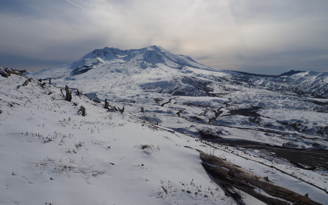
The largest part of the debris avalanche from the eruption raised the area around the trailhead by about 150 feet and covered 23 square miles. This debris flowed all the way into the Columbia River, blocking the shipping channel. There is a huge mound of dredged material piled between I-5 and the Columbia River which is slowly being carried away for sand and gravel. The landslide of the north face filled the North Fork of the Toutle River with hundreds of feet of rock and debris. It buried the river and its tributaries. Rain, snowmelt, and a mudflow from a March 1982 eruption and mudflow made new channels in the valley. Today water continues eroding the land as the river awaits the next big event to alter its course.
During the eruption a landslide blocked Spirit Lake’s only outlet. Rising water was going to flood over the unstable debris landslide and breech the blockage, causing catastrophic damage downstream. In November 1982 the US Army Corps of Engineers started pumping 80,700 gallons per minute past the landslide. This lowered the lake and rapidly enlarged the North Fork of the Toutle River and caused more of the channel to erode. Three years later the US Army Corps of Engineers completed the Spirit Lake tunnel from Spirit Lake to South Coldwater Creek passing under the landslide and providing a new outlet for Spirit Lake.
Review: 2/13/2017
Start out from the signed trailhead in the blast zone. Wind along the hummocks, passing several little ponds nestled among the hummocks. The ponds provide water for wildlife and mosquitoes. I saw one small tree that had been chewed through by a beaver.
After walking on the gravelly trail for 0.5 mile you reach the junction for the continuation of the Hummocks Trail back to the parking lot on the right, and the Boundary Trail which leads up to the visitors center. Bear left and continue for another .25 mile on the flat trail, going along the eruption debris that created the hummocks. There is plenty evidence of wildlife around this area, chewed willow branches, tracks, and deer and elk droppings.
Continuing along the trail you will climb the shoulder of a large south-facing slope with a small waterfall cascading down. Between the low elevation and the south-facing slope the sun has melted a lot of the snow along this part of the trail. Some portions are clear and others have the remains of earlier drifts. There are nice views of Mt. St. Helens all along the trail.
After climbing about .5 mile the trail uses an abandoned Forest Service Road. Where the road crests the shoulder of the hill and starts to drop down, cut left on a barely discernable trail to continue uphill. After crossing a small drainage filling with willows, check the snow depth. If the snow is more than a few feet deep, cut left to go over the ridge instead of following the trail around the steep shoulder of the ridge.
At the top of the ridge are views of the visitors center and the surrounding mountains. Being in the blast zone makes it easy to pick a route down to a small parking lot and viewpoints.
Continue a short and easy climb up to the visitors center and have a front-row seat view of Mt. St. Helens. If it is windy there are sheltered places in the architecture of the visitors center. Be sure to look for little clouds of steam slowly escaping from the dome in the crater. Having binoculars helps to see the steam clouds. On the way back, walk out to the parking lot for views of Coldwater Peak and surrounding mountains.
Retrace your steps back down the trail, passing the stumps and slowly decaying tree trunks along the way. Back near the trailhead the trail moderately climbs up to the parking lot.
Enjoy the photos!!
Gallery Pics
Switchback Steve
Recent Comments