

Vicinity Location: The trailhead is about 265 miles east of Portland, Oregon in the Eagle Cap Wilderness.
Directions:
From Portland, drive I-84 east from Portland for about 260 miles and take Exit 261 for Highway 82, La Grande and Elgin. After exiting, turn right for Highway 82, Elgin, and Wallowa Lake.
Drive on Highway 82, drive 63 miles into Joseph.
Continue on Main Street in Joseph and follow the Wallowa Lake Highway, now Highway 351, for 5.9 miles along the east shore of Wallowa Lake.
At the south end of the lake turn left at a signposted fork and drive 0.5 miles up Power House Road to the paved Wallowa Lake Trailhead.
Restrooms at the trailhead.
No permits needed to park.
Free wilderness permit needed (filled out at the trail)
Trails:
West Fork Wallowa Trail #1820, Ice Lake Trail #1808
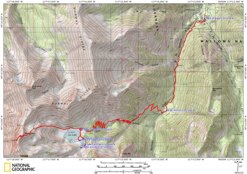
Trail Maps:
Topo Map, Download Garmin .gpx file, Open Garmin .gpx file
Length and Elevation:
21.3 miles roundtrip. Elevation at the trailhead is 4,639 feet. Total gain is 6,690 feet and loss is 6,690 feet. Highest elevation is 9816 feet and the lowest elevation is 4,639 feet.
| Itinerary | Mileage | Camp Elevation | Ascent | Descent | Notes |
| Day 1 – West Fork Wallowa-Ice Lake-Started 8:00 am – Finished at 12:25 pm | 8.5 | 7,845 | 3,850 | 638 | Lake swimming |
| Day 2-Ice Lake-Matterhorn-Ice Lake-7:25 am – Finished at 12:01 pm | 4.6 | 9,816 | 2,295 | 2,295 | Dayhike to summit Matterhorn |
| Day 2-Ice Lake-Trailhead-1:15 pm – Finished at 4:45 pm | 8.1 | 4,639 | 544 | 3,757 | Plenty of time to get a beer |
| Totals: | 21.2 | 6,689 | 6,690 |
Review: July 28, 2022
We parked at the busy Little Alps Trailhead about 8 am and saw several other people getting ready to hike and backpack. There are several trails that start at this trailhead. We checked the maps to make sure we were on the West Fork Wallowa Trail which goes along the east bank of the West Fork of the Wallowa River.
The trail is in pretty good shape for the first few miles. You stay above the river with some nice rock promontories providing views of the river. This first few miles is pretty brushy with thimbleberries and stinging nettles. Lucky for us all the other people and horses using the trail have brushed most of the hairs off the stinging nettles so as long as you are aware of the nettles you shouldn’t get stung along the way.
After about 2.7 miles you reach the junction for the Ice Lake Trail. It is the first trail heading off to the right and leading down to the river. The trail was unmarked when we were there and we noticed another group missed the junction and kept heading up the West Fork Wallowa River Trail. Walk about 200 feet to a large log with a railing crossing the river. I was surprised this wasn’t a steel bridge based on how many people use these trails. After the easy crossing on the log you begin climbing moderately af first then more steeply up many switchbacks.
The trail passes near Beauty Falls and you get some great views of Ice Falls as you climb ever higher into alpine terrain. The trail crosses a nice meadow and crosses a creek beneath the Hurwal Divide. More switchbacks lead to a flatter section of trail where you can hear the outlet stream to Ice Lake spilling through a narrow canyon.
We asked people as we neared the lake and learned the best campsites are on the left side of the lake, across the outlet stream. We saw several campsites as we ventured clockwise around the lake and stopped to talk with two women from Alaska. We mentioned the “waterfall” campsite and they told us the east side of the lake had nicer mountain views than the “waterfall” campsite. They were getting ready to leave and they let us have their prime campsite on a little cover on the lake.
We made camp, explored the lake, had dinner, and did some star gazing. The night sky is very dark here and the Milky Way was spectacular.
The next morning we set off for The Matterhorn. The forecast was for good weather with no thunderstorms in the forecast. When climbing watch for signs of developing thunderstorms because it can be deadly to get caught at the summit or exposed area during a lightning storm. Other summer storms can bring dangerous driving rain and hail. Just a couple of weeks after our trip there was a tremendous hailstorm in the area that shattered windows. Here is the link to the story: Hailstorm
We went back and crossed over the outlet stream and followed the path across a creek and with a little scrambling, headed up the trail through mountain meadows and rocky slopes. We saw mountain goats the night before and saw one on the way up. The trail gets steeper and there is some great views into a blue tarn in a bowel below you. Climbing higher you see another tarn to the south.
As you climb higher the route becomes more of a scramble with many trails leading to scree-littered slopes. Use the GPX track which is one of the better routes to the summit.
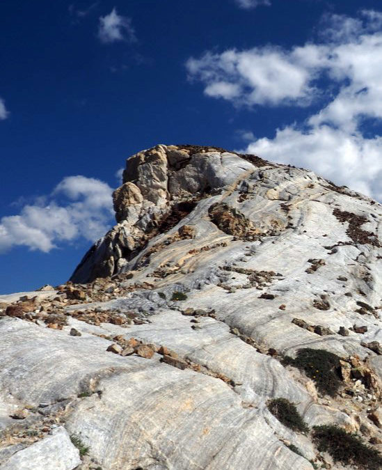
Eventually you reach the wide ridge which leads to the summit of Matterhorn and beyond. This is all marble and is amazing to see.
On a clear day you can see the expanse of the Wallowa Mountains. To the south and southwest are Frazier Lakes, the Lakes Basin, Cusick Mountain, and Red Mountain. To the west you can see Minam Peak and to the south you can see Eagle Cap.
We followed our route back down to Ice Lake where we pack up camp and headed back down the trail. On the way down we saw several people who would not get to the lake until after dark. It is really hard to find a good campsite in the dark as the spots are not marked along the lake.
Enjoy the photos!!
Gallery Pics
Switchback Steve
Recent Comments