

Note: Swale Canyon is closed during fire season usually mid-June to mid-October
Vicinity Location:
The trailhead is about 68 miles east of Portland, Oregon in the Columbia River Gorge Scenic Area.
Directions:
From Portland, OR, take I-84 East to Hood River. Cross over the Columbia River using the toll bridge and turn right on Hwy 14. Drive approximately 10 miles through Bingen, to Hwy 142 near Lyle. The lower trailhead is just on the left, at the junction.
To reach the upper trailhead from Lyle, take the Lyle-Centerville Hwy. Go north, then east for about 15 miles. Turn left on Harms Road. Drive north one-half mile and park just north of the bridge.
There are restrooms seasonally at the Harms Road trailhead and at various access points along the trail. There are restrooms at the Lyle trailhead.
No permits are needed to park at trailheads.
Trail: Klickitat Trail.
There is a geocache at: N 45° 49.292 W 121° 05.643 Info at Geocaching.com
Biking Tips for a safe ride:
1. Carry at least 3 liters of water on a hot day. You can refill water bottles in Klickitat.
2. Expect to take 3 to 5 hours to bike the entire trail.
3. Please stay on the trail. Private property is next to the trail in most places.
4. Having front suspension on your bike is a good idea.
5. Carry a tire pump, repair kit, and spare tube. Yellow-star Thistle burrs, or Goat’s Head commonly puncture tires.
6. Slime in your inner tubes will help prevent flats.
7. Carry extra food, sun screen and a first aid kit.
8. Beware of poison oak, rattlesnakes and ticks. Lyme Disease is from ticks is possible so check for ticks at each rest stop.
9. The only access for Swale Canyon is at the trailheads.
10. There is not good cell phone coverage on the trail, especially in Swale Canyon.
11. Swale Canyon is closed in summer and early fall because of fire danger, usually mid-June to mid-October. Check the KTC web site for updates.
Shuttle Information: I called Carl at the Canyon Market, 100 Main Street in Klickitat. The phone number is 509-369-4400. You should be able to make arrangement to have Carl move your car from the upper trailhead to the lower trailhead. Be sure to call about a week in advance in the summer. In 2012, he offered shuttles in the 30 through 35 dollar range.
Another possibility is to call Rolf at the Klickitat Trader 509-369-3179 though I have not verified this. Plan for about 30 to 45 minutes to drive from on trailhead to another.
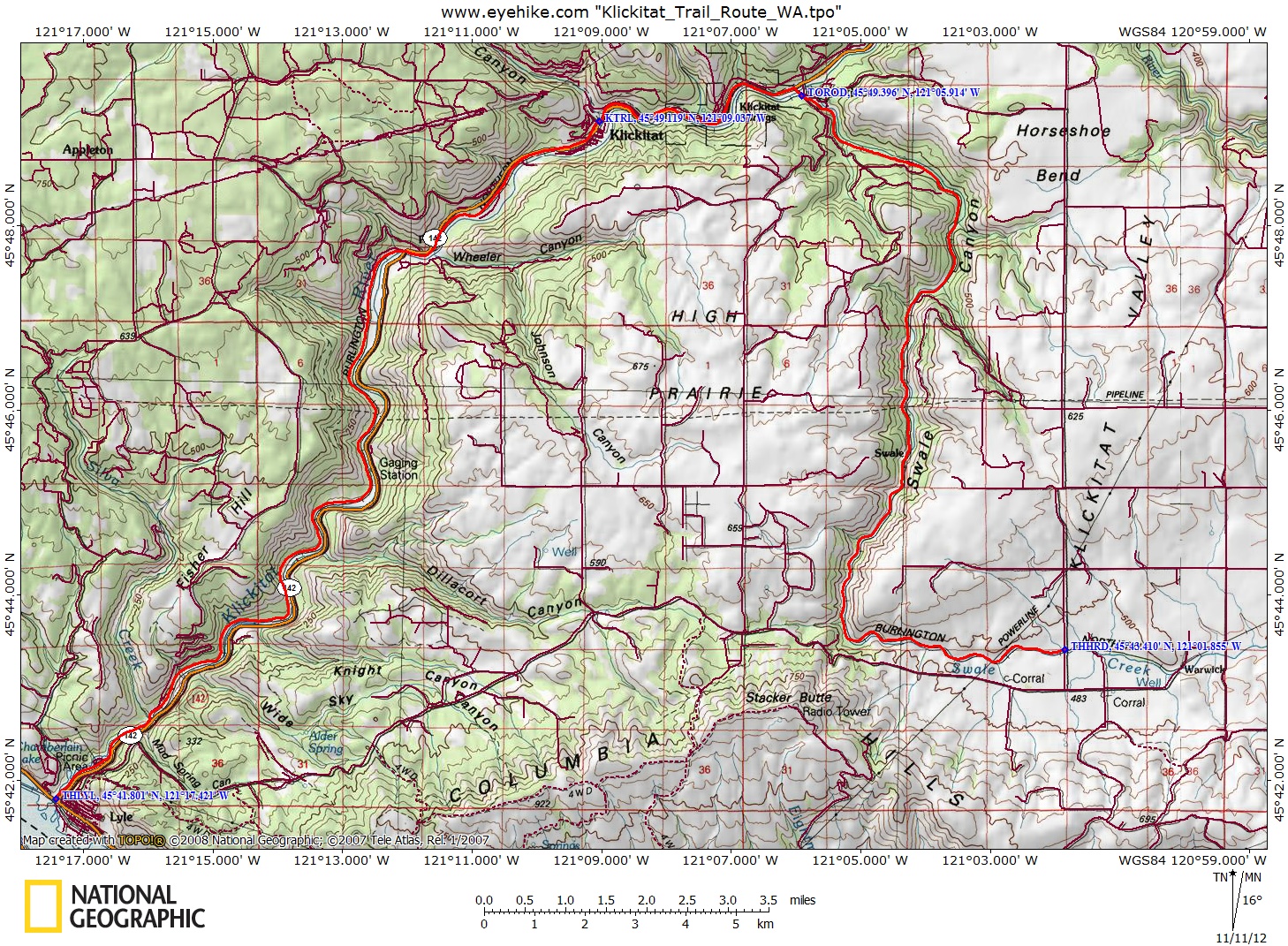
Trail Maps: Topo Map, Download Garmin .gpx file
History: The terrain of Klickitat County was formed by the Columbia River basalt flows that started about 1.8 million years ago and end ended about 16,000 years ago. The Columbia River gorge was formed by the “Missoula Floods,” the greatest series of floods known to have occurred in North America. The floods reached depths of 900 feet in the Gorge and reached speeds of over 75 miles per hour.
The name Klickitat is usually considered to be a Chinook word meaning “beyond,” as in beyond the Cascade Mountains. Lewis and Clark called the tribe the Wah-how-pums. The Klickitats were divided into an eastern group occupying the Klickitat and White Salmon River areas and a western group called the Taitnapams who lived west of the Cascades near the Cowlitz and Lewis rivers. The Klickitats were skilled horsemen, hunters, and traders. The women were noted for their intricately woven basketry. The Klickitats were one of 14 tribes grouped together as Yakima (or Yakama) at the June 1855 Walla Walla Council and were signatories of the Treaty of Yakima.
In 1903 the Columbia River and Northern Railroad built a line between Goldendale and Lyle. In 1970 the Spokane, Portland, and Seattle Railroad became part of Burlington Northern.
After the completion of the Columbia River & Northern Railroad linking Lyle with Goldendale, the vast majority of goods moving in or out of the Klickitat Valley came through Lyle. In recent years Lyle has emerged as the nucleus for Klickitat County’s growing wine industry.
The Western Pine Lumber Company built a mill and logging railroad at Klickitat in 1909. The mill was destroyed by fire in October 1918 and immediately rebuilt. In 1922, the J. Neils Lumber Company purchased the mill and property, enlarging the Klickitat townsite. Another mill fire happened in 1927 and the mill was rebuilt. In 1957, the St. Regis Paper Company bought the mill operations, which merged with Champion Lumber in 1984. The Champion Mill in Klickitat closed permanently in November 1994.
The railroad right-of-way was purchased in 1993 by the national Rails-to-Trails Conservancy. Ownership of the rail line was transferred to Washington State Parks in 1994. There was local opposition, including barricades across the trail and gunshots fired to harass early users of the trail. Eventually public support prevailed and in 2003, the Klickitat Trail Conservancy (KTC) was formed. The Trail is managed cooperatively by Washington State, the U.S. Forest Service, and the KTC.
The roadbed, trestles, a few spikes, pieces of rail, and the caboose in Klickitat are all that remain of the railroad.
Lyle was once an important port after the construction of the Cascade Locks in 1896 because it was the first port upriver from Portland, Oregon that was unimpeded by falls and rapids on the Columbia. The town was originally named Klickitat Landing but was changed to Lyle in 1882. Source- HistoryLink.org
Length and Elevation:
29 miles one way. Elevation at the Harms Road is 1,560 feet. Elevation at the Lyle trailhead is 120 feet. Elevation gain totals 100 feet. Total gain and loss is 1,540 feet one way. Highest elevation is 1,560 feet.
Review:
November 10, 2012, April 3, 2016, April 15, 2017
Please remember to shut any gates you open. You may encounter cattle on the trail. Please keep your dogs leased to avoid your dog from chasing cattle and causing injury or death to any cattle.
From the Harms Road trailhead, walk past the gate and cross a board-covered trestle over Swale Creek. The trail is packed down with a few bumps and divots. You soon pass through 2 more gates, which are the last for the trip, at least during daylight hours. South of Klickitat are some gates that are shut after daylight hours.
From here there are some nice views as the walls of the canyon grow taller with as you bike downhill. If you look, you can see a house on the rim of the canyon, but this is the last house for several miles.
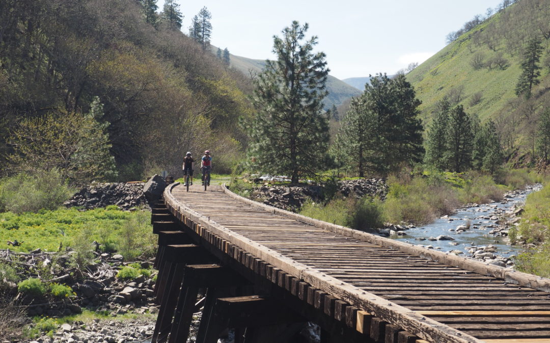
Continuing down the canyon, the path is mostly sandy gravel but there are a couple of 500 foot stretches of loose ballast. One of the trestles has been covered with rocks washed into the canyon. A short pedal over rocks gets past the washout. Pass over 3 trestles that aren’t covered with boards. Riding across the ties is an interesting experience as you pedal across the open ties. It is a little frightening bumping across the trestles. There are a few spikes along the trail but very little glass.
After about 9.5 miles, the trees start changing from Ponderosa Pines to Douglas Firs, with a lot of oak trees on the hills. Even this far down the canyon, the creek is pretty small in the fall.
The path passes by a couple of old homesteads with a lot of derelict items in the yard.
At the next trailhead, you will find a KTC port-a-potty in the parking area. From here, you have to take the road because about 2 miles downstream the Subrubia bridge is missing.
To rejoin the trail, turn right onto Schilling Road and pedal a short distance on the gravel, then left onto the paved Horseshoe Bend Road. Continue across the concrete bridge over the Klickitat River and turn left onto SR 142. This area along the river is the unincorporated community of Wahkiacus. From here, bike 3 miles downstream to the town of Klickitat.
There isn’t much of a shoulder and in some places there is no shoulder, but the highway isn’t very busy
Just before the town of Klickitat look for the trail to leave the highway off to the right. A good place is just before the caboose. You can stop at the nearby Canyon Market for water or a snack. The trail goes through the town and then crosses the road just a little bit outside of town.
The trail continues along the Klickitat River down towards the Columbia River. You pass through a section where someone has planted hundreds of apple trees along the trail. The trail narrows and goes over a nice little bridge with gravel approaches.
The next short section of trail is a mountain bike trail as it twists and turns through the woods and crosses small patches of mud. The trail goes up a small hill and then rejoins the roadbed.
At Fishon Road, the trail crosses back over Highway 142 and continues to parallel the river. Look down the dirt road for the continuation of the trail.
In the afternoon the sun settles behind the hills in the west, providing shade along the trail. This next section of the trail is across the river from Highway 142. The trail passes several small farms along the river and passes through several gates that can be left open during the day.
This section of the trail is in really nice shape and passes under oak trees and cottonwood trees.
This trail is mostly easy with challenges along the way. At 8 miles from the lower trailhead is a section that is washed out. There is a path up the hill a bit and through the woods.
The route passes back into a forest of pine and oak as it gracefully follows the river. Sometimes you hardly notice the gravel at all because the pedaling is so easy and you can hear the sounds of the river whenever you stop to admire the scenery.
Travelling down the trail is a little like travelling through time, seeing pieces of the past poking through to the present, like parts of old railroad ties, railroad spikes, rusty bolts, and metal plates. There are even old apple trees that were loved in the past but are now abandoned to time.
There is a narrow section of trail around 5 miles from the lower trailhead where the river is slowly washing away the railroad bed. It looks like each large flood will successively wash away more of the trail until it is gone. You will want to check trail condition to be sure this section is open. If it washes out, the steep cliffs along the trail will prevent a detour.
At 2 miles from the lower trailhead, there is a road for the Klickitat Fish Hatchery which you cross, then cross a small patch of loose gravel and continue along the well-packed path.
Pass over the Fisher Hill Trestle over the Wild & Scenic Klickitat River. The trestle has been renovated with a concrete deck and sturdy railings. From here it is an easy ride paralleling Highway 142 down to the lower trailhead. The trail is well packed gravel all the way down to the Lyle trailhead.
Enjoy the photos!!
Gallery Pics
Switchback Steve
Recent Comments