
Vicinity Location:
About 240 miles north of Portland, OR and about 135 miles northeast of Seattle in the Mt. Baker-Snoqualmie National Forest.
Directions:
From Portland: Drive about 300 miles and 5.5 to 6.5 hours through Seattle.
From Seattle: Drive on I-5 for about 240 miles and take exit 232 for Sedro-Woolley. Drive 5.2 miles to Sedro-Woolley and take Hwy 9 North for 30.5 miles to Hwy 542.
Take Hwy 542 East for 41.7 miles driving through Maple Falls and other communities to the trailhead area.
A Northwest forest permit or equivalent is required to park here.
Blue bags or equivalent are required and you are required to pack out your feces.
There is no wilderness permit needed for day use but permits are required for all overnight camping in the back country of North Cascades national Park. You have to pick up the permits at a ranger station as they are not available at trailheads. Lake Ann is not in the National Park.
There is no bathroom at the trailhead.
Length and Elevation:
11.4 miles roundtrip. Elevation at the trailhead is 4,755 feet. Total gain is 3,390 feet and loss is 3,390 feet. Highest elevation is 5,269 feet and the lowest elevation 3,907 feet.
Trails:
Lake Ann Trail #600 with connections Swift Creek Trail #607 and Sulfide Glacier Route.
There is at least one geocache at: N 48° 49.856 W 121° 38.597 Info at Geocaching.com
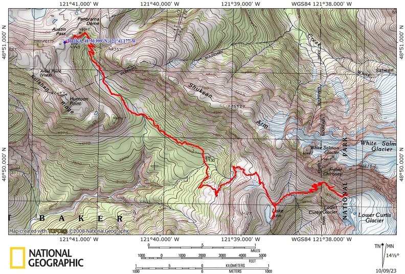
Trail Maps:
Topo Map, Download Garmin .gpx file, Open Garmin .gpx file
Review: August 16, 2022
The trail begins a gentle descent through a lovely forest. You soon pass a service road on the left with a view down into the valley below. Stay on the trail by dropping below the service road and beginning a long downhill descent. Don’t continue walking on the service road.
The first part of the trail is very well-maintained with rock armoring along the trail, numerous dream dips, and other features to keep the trail in excellent shape. As the trail begins to drop more steeply and switchback down through the forest. It becomes a little rocky and a little more rooty but still a nice trail.
There are plenty of huckleberry bushes along this first section of trail which winds through a forest of hemlock, noble firs, and wildflowers. There are large old-growth trees here mixed in with a younger trees. This open and diverse forest allows you views of the nearby ridges.
In less than a mile you reach the valley floor of a small stream which flows gently downhill which flows the same direction you are heading. The trail here is a turnpike with sections that are small cobblestones or river rocks and then other areas where the water has washed out the trail and gouged all the gravel out of the trail. Walk along this for half mile or so and then start descending more steeply through meadows and forests down to a small creek crossing. From here you begin ascending up the side of a ridge, switchbacking up the hillside. There’s another small stream to cross and views of Mount Baker come into view through the trees.
The forest thins out with a mix of stubby younger trees and older storm damaged trees with an understory of huckleberries, blueberries, and mountain ash trees.
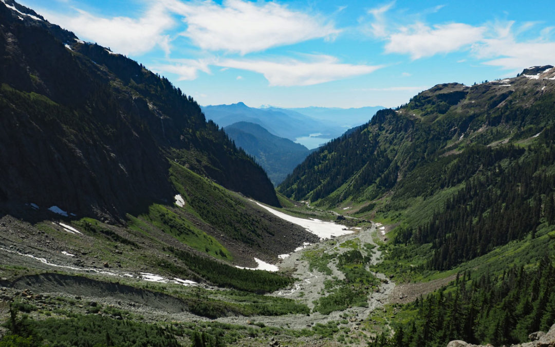
Soon you climb up through a hanging meadow and into a large rockfield with alpine ladyferns. This brings you totally above the trees with excellent views of Mount Baker to the right.
Continue climbing switchbacks through a V-shaped mountain valley and have more great views of Mount Baker.
Climb up through the valley and then you will crest over a small ridge with Lake Ann down below. You can stop at the lake then turn around or continue on to the glacier which is the plan for this hike.
Past the lakes the trail drops down through a small hanging valley and crosses a beautiful mountain stream. From there the trail begins to ascend at first moderately then steeply switchbacks up towards the glacier. There are sections in the switchbacks where the dirt tread has been worn away and you have to clamber over the sloping rock face to stay on the trail. There is some shade along here but mostly you are exposed to the sun. Getting up higher you get wonderful views of Lake Ann and Mt. Baker.
Switchback up farther and come to the boundary for North Cascades national Park.
The trail has some sketchy or sections as you cross some squeeze lobes climbing ever higher. There is one spot that drops downhill from the trail which looks like the trail but really is not. Continue climbing and climbing past incredible views of the base of the glacier. Obviously the higher you climb the better the views get.
We discovered that there is a large snowfield and it looks like a very hazardous crossing in high snow years and early in the year. To continue on the trail you need to detour down below and around the snowfield then scramble up along the far side of the snowfield. This review stays on the lower trail heading towards the tie of the glacier.
Backtrack a bit and look for a trail and cairn which drops sharply down a rockfield and follow that and make your way around one or two snowfields. Even on the lower trail there may be dangerous snowfields and you should turn around.
The trail that dropped off the main trail does not re-join it. It has two ridge where you can climb up above the toe of the glacier for a great place to stop and take a break and admire the views.
The actual trail heads up into the rocks past the snowfield. Look for a shallow green cleft in the cliff heading up diagonally which up climbs up to the cliffs towards Mount Shuksan.
On the way back, stop by Lake Ann to wade or swim. This can be a very cold lake with snow at the edge of the lake through August. The far end of the lake has the best places to wade or swim. There are also a number of campsites at this end of the lake.
After you are finished enjoying the incredible views at the lake continue back along the same trail and return to the trailhead.
There is Verizon cell service at the lunch spot. There are also a couple of places along the trail with cell service too.
Enjoy the photos!!
Gallery Pics
Switchback Steve
Recent Comments