
Notice: 06/26/2023: The June Lake Trailhead is now open for the season. If you are planning to do an overnight trip on the Loowit Trail, please do not park in this parking lot as it can only accommodate a few vehicles. Instead park in the overflow lot at Marble Mountain and use the Pine Marten Trail to access June Lake. This adds about 1.6 miles each way, for a total of 3.2 miles to your trip.
Vicinity Location:
About 49 miles north of Portland, OR in the Mt. St. Helens National Monument.
Directions:
From Seattle – take I-5 south about 150 miles and take exit 21 at Woodland, WA. Drive about a .5 mile on the frontage road and turn left at the traffic light onto State Route 503. Drive about 28 miles east through Cougar, Washington, to Forest Road 90 and another 6.8 miles to Forest Road 83, turn left onto FR83 and drive 7 miles to the turnoff for June Lake. Turn left and drive .1 mile to the trailhead parking area.
From Portland, OR – take I-205 north to exit 30b to Battle Ground. Move over to the middle or left lane and proceed north on SR503 for about 10 miles to Battle Ground. Continue north on SR503 past Chelatchie Prairie and Amboy. At the junction of Lewis River Road and SR503, turn right and continue on SR503 past Cougar. SR503 turns into Forest Road 90 just past Cougar. Drive another 6.8 miles to Forest Road 83, turn left onto FR83 and drive 7 miles to the turnoff for June Lake. Turn left and drive .1 mile to the trailhead parking area.
Note: if you are driving from Portland during rush hour, continue on I-205 or I-5 north to Woodland, take exit 21, turn right, and drive about 28 miles east through Cougar, Washington, to Forest Road 90 and another 6.8 miles to Forest Road 83, turn left onto FR83 and drive 7 miles to the turnoff for June Lake. Turn left and drive .1 mile to the trailhead parking area.
There are no bathrooms at the trailhead. The nearest bathroom is at Marble Mountain sno-park.
No permits needed to park.
No dogs are allowed in large portions of the monument, including this trail.
Length and Elevation:
35.6 miles
9,180 feet of elevation gain
9,180 feet of elevation loss
Daily Stats:
June Lake Trailhead – 2,800 feet in elevation
Night 1 camp – 4,194 feet in elevation
4.5 hours of travel time
Traveled 6.65 miles at about 1.4 mph
2,230 feet of elevation gain
880 feet of elevation loss
Night 2 camp – 3,220 feet in elevation
11.4 hours of travel time
Traveled 15.5 miles at about 1.4 mph
3,420 feet of elevation gain
4,330 feet of elevation loss
Day 3
Finished at June Lake Trailhead – 2,800 feet in elevation
10.3 hours of travel time
Traveled 13.47 miles at about 1.3 mph
3,530 feet of elevation gain
4,000 feet of elevation loss
Trail:
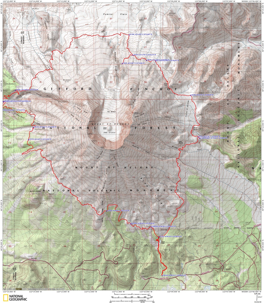
June Lake Trail, Loowit Trail with connections to multiple trails.
Trail Races:
Early August – Volcanic 50
Mid-August – Bigfoot 200
There is at least one geocache for this trail at:
N 46° 12.230 W 122° 08.209 Info at Geocaching.com.
Trail Maps:
Topo Maps, Download Garmin .gpx file
Review: July 7 – July 9, 2017
We arrived at the June Lake trailhead about 2:30 on a Friday afternoon to a fairly busy parking lot. We organized our gear, making sure we had trekking poles, gaiters, and good boots. The streamside walk up to June Lake is a wide gravelly trail and a moderate grade. After about a mile we crossed over a stream and walked along a willow-lined path through a break in the willows to June Lake. There are several hidden waterfalls in the forest surrounding the lake but one nice waterfall plunges right down to the shoreline. After our snack break we walked up the narrow and fairly steep trail and turned right at the junction of the Loowit Trail and passed a nice little spine that overlooked an emerald pool nestled below the trail.
Travelling back into the heavy forest we passed a few massive trees and then broke out onto a blocky lava slope. There was some easy rock hopping mixed with gravelly trail. Now the trail turned into the back of a swerving Chinese dragon dancing in the street, dropping into gritty gullies, crossing seasonal streams, and climbing back out again. The frolicking trail went through ever bigger peaks and valleys where erosion had washed away most of the tread on the sides of the gullies. Finally after one last heave the Chinese dragon laid down for a nap.
We slowly descended across the floodplain of the Muddy River and gathered water for our dry camp at one of the seasonal streams then took the short walk up to our camp near the junction of Ape Canyon Trail to a spectacular campsite on the top of a little knob. We had a view of the four major peaks. It was a great view of the moon rising and the alpenglow on Mt. Adams while we were making dinner.
Saturday I got up early because of the long day ahead. The sun was shining on the fog in the lowlands and I took pictures of the scenery around our great camping spot.
Heidi and I got packed up and hit the trail about 7:45. It was a pretty short distance to Pumice Butte and two little seasonal streams flowing over the cliffs. From there we passed over the Plains of Abraham, a large pumice plain where the trail is shared with mountain bikes. The trail is good here as the mountain bikers keep the rocks off the trail. Crossing the plains, we passed a couple of backpackers who needed to camp at the pass because the night overtook them.
Eventually mountain bike activity ends as you get close to Windy Gap. The trail disappears from washouts on the plains and at the bottom of Windy Gap.
We searched the hillside for where the trail should start and made our way across the rocky outwash picking up the trail again after about 500 feet. The approach to Windy Pass was a bit of a scramble in the places where the trail was gone and only the gravelly bedrock remained. After gaining about 100 feet in elevation we could follow the track again up to the pass. There usually is maintenance that repairs the trail later in the season. A sensible option for the early season backpackers is to use the Abraham and Windy Ridge trails to avoid this section. I hear this alternate route passes through nice wildflower meadows.
It wasn’t very windy at the namesake pass and used our maps to determine the trails drops down out of the pass. There are nice views of Mt. Rainier, Spirit Lake, the surrounding mountains, and Alpine Butte is the hill on the right at the pass. The trail on the left that we saw at the top of the pass must just be a viewpoint trail that climbs up a nearby hill. We soon discovered the trail down wasn’t a whole lot better than the trail up. You need to step carefully because parts of the trail have been blasted out of the hillside and are lightly covered with rounded pebbles and pumice dust. A miss-step on the very steep mountainside could be fatal.
After a bit the switchbacks led us down to the plains where we travelled along the trail through the desolation to Big Springs where we stopped for lunch and filled up at the last reliable source of water until the Toutle River. You can’t miss these springs because they gush forth onto the trail. In this section the trail traces rocky fingers of the lahar and slowly gains elevation to the junction to Loowit Falls.
Heidi and I stashed our packs under a nearby alder and headed up to viewpoints of the falls. The trail has become pretty established and rocks have been kicked aside over the years leaving a somewhat sandy trail up to a viewpoint of the falls which roar into a wide cleft in the mountain. Returning to our packs, we ventured to Loowit River and nice views into the crater. It is generally known the glacier is one of the only glaciers in the U.S. that is growing as it is in shadow much of the day.
We could only jump to the middle of the Loowit and had to wade the rest of the way though it was only knee deep. The streambeds are getting deep as you now have to look for a place to climb down about a four foot drop to the streambed and about a five foot climb out but it isn’t hard to find a route.
Soon the trail climbs out of the desolation and crosses wildflower meadows sprinkled with small trees. We passed strawberry fields, leaving plenty for other hikers. The trail crosses several more very large gullies, one of them having a fairly long descent. A couple of them had seasonal streams which were easily crossable.
There was one last climb up to a large park-like area where the trail was very sandy, plenty of low-growing Kinnikinnick, and the distant roar of the river. Soon we began the long descent down to the Toutle River with the trail going down a huge slope of loose, gritty soil where the hillside sluff is always trying to cover the narrow trail.
After about ½ mile of this kind of trail, we got into a more normal, brushy trail that continued switchbacking down and then we came to where the river has eaten away the bank. There is a rope that you have to use to descent to the riverbed. We put our poles onto our pack so that we could use both hands to almost rappel down the escarpment.
The Toutle River was too wide and deep to jump or rock hop, even in the afternoon. Wading with trekking poles wasn’t too difficult though the silty water disguised a little dropoff I stepped into. Luckily just the cuff of my shorts got wet. The south side of the Toutle River has two ropes that have to be used to climb out of the streambed. You can go upstream on the first shelf above the river for about 300 feet and there is a nice sandy camping area. We camped on the second shelf and walked about ¼ mile each way to Crescent Creek for clear water. There may be camping on the south side of Crescent Creek but I didn’t look.
The sun went behind the hill as we talked about our adventures on the trail.
Sunday was another beautiful day and we made the best of it by breaking camp about 7:30 am, heading up the overgrown trail which led up the west side of Sheep Canyon. There were a few views across the Toutle River where you could see yesterday’s switchbacking trail. There were a few deadfalls walking up the steep, sandy trail and nice views to the north and east through breaks in the forest.
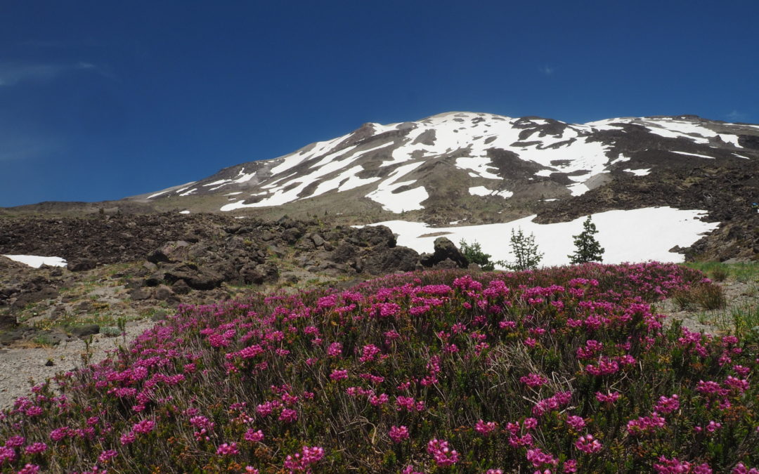
On this section of trail the forest was unaffected by the volcanic blast and is home to bands of black flies. The trees shade the trail and the forest floor is carpeted in green sprinkled with wildflowers. After climbing over 1,500 feet and about 90 minutes we passed back into the lava landscape, though nature is reclaiming the once barren slopes. There are many patches of wildflowers and heather dotting the slopes. We found a good spring for water about ½ mile farther. The spring is about 50 feet lower than the trail in a patch of trees and brush. We walked down a dry streambed and then cut into the bushes. Some spines of the mountain still have trees and we stopped for lunch at the first treed ridge with views of Mt. Hood. The wind was blowing about 15 mph that afternoon on the west slopes and picking up a little dust. We wondered how much dustier it was for those climbing the summit.
The winter of 2016-2017 was a heavy snow year but I was surprised that in early July there were still several large snowfields to cross which were at 4,600 feet and in full sun. The snow was very consolidated and we took care crossing the snowy slopes because we didn’t want to slide down into the rocks below.
We soon came to a huge washout. What was once about 350 feet of level trail is now a .8 mile detour which loses 500 feet in elevation and then regains it again. Even more interesting is now you have to lower yourself down the last 50 feet into the gully, walk downhill and find the other rope that you have to use to help climb out of the gully. If that rope is missing, you would have to walk down the gully quite a bit farther to find a place to climb out. Early in the season you should check to make sure these ropes and the ones on the Toutle River are in place. The uphill reroute is very faint in places but always stays within about 150 feet of the edge of the ravine.
Back on the old trail there are a couple more washouts that require a bit of scouting to find the other side. There is a section of rock-hopping to get through before re-entering the forest. Of course the views along this section are fantastic on a sunny day and you might even see some mountain goats.
Back in the forest there were patches of icy snow before and after crossing the Ptarmigan Trail. This is the most used trail for summiting Mt. St. Helens and there is a good chance you’ll meet someone at the junction. There is now about 4.5 miles left and they are hard miles. The first part is along a forested slope then across open meadows then dropping down through the forest and crossing two streams to meet the Worm Flows climbing route trail. There is camping by the stream here but the landscape is a mixture of boulders and ashy soil with a thin forest of pine trees.
Cross a boulder field and as you venture through the boulders there are pieces of trail that appear along the marker poles. Cross the seasonal stream that flows over Chocolate Falls, which is named for the dark bands of lava at the falls. Look for the Loowit Trail, which will stay fairly level and soon enters what seems an endless field of abrasive black boulders. This is another place where trekking poles are very handy so you don’t have to scrape up your hands on the rocks.
Eventually the trail returns to the forest, skirting the lava flow, then drops down to the junction for the June Lake Trail. The afternoon light was very nice for taking more pictures of the waterfall at June Lake. The wide, well used trail down to the trailhead seems to take longer than expected as you think the parking lot is just around the next corner but of course, inevitably the trip is over.
Enjoy the photos!!
Gallery Pics
Switchback Steve
Recent Comments