

Vicinity Location: The trailhead is about 165 miles north of Portland, Oregon in the Olympic National Forest.
Directions:
From Portland drive north on I-5 about 100 miles and take exit 104 to Hwy 101 North for 85.7 miles and make a sharp left on Penny Creek Rd which is just past the Quilcene National Fish Hatchery.
In 1.5 miles Penny Creek Rd turns into NF-27. Drive on NF-27 for 9.2 miles then bear left to take NF-2750. Drive another 4.7 miles to the Upper Big Quilcene Trailhead/Marmot Pass Trailhead.
A Northwest Forest pass or equivalent is needed to park.
There is a pit toilet bathroom at the trailhead and additional bathrooms at the Tubal Cain Trailhead.
Notes at the trailhead remind you to be vigilant while hiking. There was a yellowjacket nest next to the trail reported to be about 1.25 miles up the trail.
Length and Elevation:
Total distance is 44.7 miles. Trailhead elevation is 2480. Highest point is 6,969 feet. Lowest point is 2,308 feet. Total ascent is 13,398 feet and total descent is 13,420 feet.
| Itinerary | Mileage | Camp Elevation | Ascent | Descent | Notes |
| Day 1 – Upper Big Quilcene/Marmot Pass Trailhead-Boulder Shelter-Started 8:30 am – Finished at 5:30 pm | 14.9 | 4,900 | 5,867 | 3,470 | Dayhike 7.3 miles to Home Lake |
| Day 2– Boulder Shelter-Buckhorn Lake-Started-Started 8:00 am – Finished at 5:30 pm | 19.1 | 5,160 | 4,808 | 4,547 | Dayhikes to B17 crash and Tubal Cain Mine |
| Day 3 – Buckhorn Lake-Upper Big Quilcene/Marmot Pass Trailhead-Started 8:05 am – Finished at 2:25 pm | 10.7 | 2,480 | 2,723 | 5,403 | Dayhike to Buckhorn Peak |
| Totals: | 44.7 | 13,398 | 13,398 |
Trails:
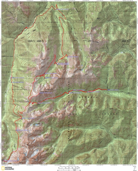
Upper Big Quilcene Trail #833, Upper Dungeness Trail #833.2, Constance Pass Trail, Dungeness Road, Tubal Cain Trail #840, Tull Canyon Trail #847, Buckhorn Lake Trail #845, Buckhorn Mountain Summit Trail with connections to Constance Pass Trail and unmaintained trails.
There is at least one geocache at: N 47° 50.951 W 123° 06.176 Info at Geocaching.com
Trail Maps:
Topo Map, Download Garmin .gpx file, Open Garmin .gpx file
Review: September 16, 2023
Climb up through a forest along a nicely maintained trail. There’s lots of Hemlock and cedar trees, a few rhododendrons and huckleberries, Oregon grape, ferns, and devils club growing along the trail. About 1.7 miles cross a stream that flows all year, in case you need to stop here and get some water. The trail has moderate and fairly steep climbs up a sylvan mountainside through a beautiful forest. The fir needle covered trail winds just above the Big Quilcene River. We spaced ourselves out and were very vigilant for yellowjackets around the 1.25 mile mark.
At just over 3.5 miles you suddenly break out of the trees and ascend along the side of a rocky ridge. Wonderful mountain views open up on the trail as it climbs high above the forested valley floor.
Climbing higher you pass through patches of trees and alpine meadows. A grove of trees shades Mystery Camp. There are lots of campsites at Camp Mystery as well as several year-round springs here. We filtered water here because there was no more water for 2.5 miles until the stream just before the Boulder Shelter.
It is a fairly steep climb up to Marmot Pass. There are nice views all around and you can see down to the Hood Canal. I had Verizon cell service at the pass and I was able to post a picture of a view from Marmot Pass.
At the pass If you walk to the left there is a user trail with more nice views,and even a one person campsite right on the ridge.
Continuing on the trail, turn left at the pass and follow the Dungeness Trail as it goes beneath Boulder Ridge then descend several switchbacks to the junction to Home Lake and the Boulder Shelter. The Boulder Shelter was in good repair at the time of this review. There are a couple campsites around the Boulder Shelter and a few near the junction to Home Lake.
We picked a campsite, dropped our packs, then headed along the trail towards Home Lake for a dayhike. From the junction for Home Lake climb fairly steeply to the junction to Charlie Lakes. Take the right fork of the trail towards Home Lake.
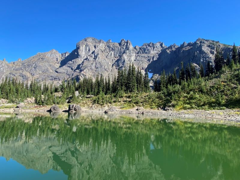
The grade of the trail is mostly moderate as it goes along Home Creek valley. There are a couple of nice little streams crossing the trail before entering a rockfield. Drop down through the rockfield and cross the usually dry streambed of Home Creek. From there climb about 600 feet in less than a mile to the bowl containing Home Lake. The small lake is nestled between high, rugged mountains. It is a cold lake to swim in and parts of the bottom along the shore are muddy and other places have boulders at the lake shore.
There are a couple pretty good campsites and a couple that are rocky and sloped. If you want to camp here you need a National Park camping permit.
We returned back along the trail to our campsite near the Home Lake Trail junction and set up camp. We had a beautiful campsite with views of the mountains and the sounds of the constant splashing of the little stream. We were pretty tired after dinner so we talked for a while then went to bed.
Day 2
We started the day with a beautiful walk through the forest. The trail drops gently along the Dungeness River and eventually reaches the parking lots for the Dungeness Trailhead. Cross over the river on the road bridge and there is a vault toilet at the edge of the parking lot.
From there go uphill on a long road walk along a gravel road. After going up and down a little it is mostly a steady climb up to the Tubal Cain Trailhead. About 12 cars passed us as we walked up the road and just one was going pretty fast. The road is wide enough to easily step aside.
On the Tubal Cain Trail, there is a nice stream for water about 0.1 mile from the trailhead. You will start out through a zone of rhododendrons and salal with the predominant trees being hemlock. The trail is very well maintained and rises at a moderate grade.
Several streams cross the trail on the way up to Tubal Cain Mine. It is a bit of a scramble along the left side of the old tailings pile up to the mine.
Tubal Cain Mine has water coming out from the mine entrance. You need a headlamp to explore the mine and there were two hardhats at the entrance. People have carried in small logs to walk on but eventually you will have to wade through shallow water to go deeper into the mine.
There are several camping spots along the trail here and plenty of water is nearby.
Shortly after leaving the mine there is a junction where you can climb steeply for 0.6 miles or take the official trail on a gentler grade for 1.6 miles. We took the junction to the right for the gentler trail. The grade was moderate and the trail was well maintained. We switchbacked across an alpine meadow with great views of the mountains across the Copper Creek valley.
Coming up the ridge later in the day gave us shade in the open meadows making for a pleasant climb
We dropped down a bit to the upper junction of the shortcut trail then soon came to the junction for Buckhorn Lake.
The lake is the trail to the left and the little trail crosses a scree field as it drops and then it climbs a few times to some campsites above the lake. There is one small sloping site at the lake but it did not seem enticing.
The lake is small and has many dead trees lining much the shore. There are some nice views of mountains towering above but the lake itself is uninspiring.
There was a small stream crossing the trail to the lake, just below our camp, where we could get water to filter, After that we went back to camp to fix dinner. This time of year there were no bugs at the campsite.
We had some rum and whisky, had a good conversation, and went to sleep with the whispering of the small streams.
Day 3
We woke up to the faint smell of smoke from fires on the Olympic Peninsula. The shorter days meant just a faint light and the lake is between high ridges that keeps the sun out until late morning.
We had breakfast and broke camp by 8 am for the long climb. We climbed up away from the lake and climbed up through steep alpine meadows to Buckhorn Pass. Buckhorn Pass has great views of the Dungeness and Copper Creek valleys. From the pass there are some fairly steep sections of trail to the trail junction to Buckhorn Peak. This is the second choice of a trail and is the trail very near Marmot Pass.
We cached our packs at the junction and took the trail which is very steep but well trodden. We reached the summit then checked our maps looking at the castle-like peak in the distance and saw the peak was Buckhorn Peak. We were on a false summit. We followed the path down across a saddle then started another steep climb and short scramble up to Buckhorn Peak. The peak is a collection of boulders and it is difficult to know which is actually the true summit so take your pick.
On a clear day you can see Mt. Adams, Mt. St. Helens, Mt. Rainier, and other distant peaks but the smoke blurred our views. We were somewhat above the smoke so after taking photos and enjoying the views on an almost windless day we headed back down.
Back at the trail junction we made the short walk to Marmot Pass where I again had cell service on Verizon. I found it odd that there was no service on Buckhorn Peak. We decided to continue down the trail and have snacks and filter water at Mystery Camp.
There are plenty of campsites around Mystery Camp and good water to filter. We found a good log to sit on in an empty campsite. Heading on down the trail we had already forgotten how steep this trail is. After being careful in the vicinity of the reported yellowjacket, we finally arrived back at the trailhead. Cars parked down the road told the story of the parking lot overflowing on the weekends even in the fall.
Enjoy the photos!!
Gallery Pics
Switchback Steve
Recent Comments